Check Out Our Holiday Auction!

Forecast for the Uintas Area Mountains

Craig Gordon
Issued by Craig Gordon on
Monday morning, December 1, 2025

The good news... contiguous pieces of snow are easy to identify and confined to upper elevation, shady slopes. The bad news... those are exactly the types of slopes that offer the greatest danger, because where it's white... it's super weak underneath yesterday's storm snow! And though the avalanche danger is generally LOW, please don't get lured into thinking there's not enough snow to avalanche. Steep, wind-drifted slopes in the wind zone above treeline is bullseye terrain and I bet there's a wind drift or two lurking on the leeward side of a chute or gully that'll react to our additional weight.

It's extremely thin out there and our snowpack is weak, so I gotta remember... once triggered, today's slides will break deeper and wider that I might expect and even a small piece of snow will pack a powerful, season ending punch.

Low
Moderate
Considerable
High
Extreme
Learn how to read the forecast here
Special Announcements

Avalanche Awareness Week starts December 1st... that's today! We kick off the week with free community avalanche rescue and first aid practice at Sugarhouse Park on Monday, December 1 from 4 PM - 7 PM. Events are happening daily across the state to prepare you for winter and get you thinking about avalanche safety. Find out about all our events HERE. And don't forget the Utah Snow and Avalanche Workshop is Saturday, December 6 with in person and virtual options!

But wait... there's more!

Weather and Snow

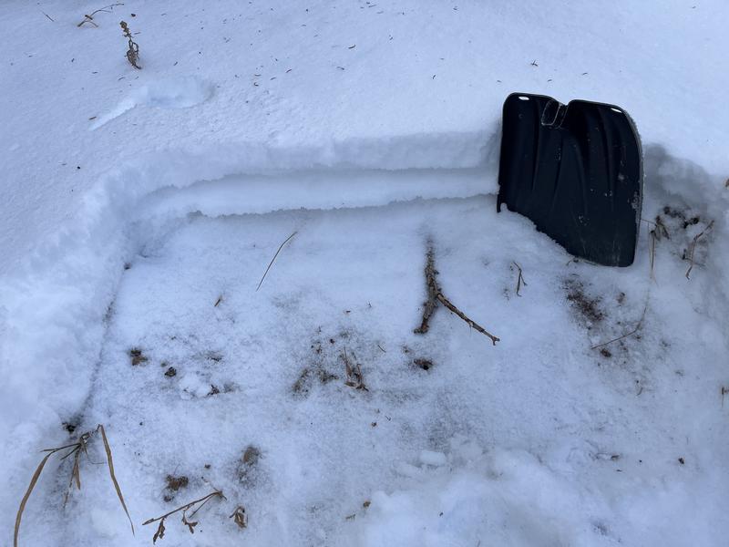
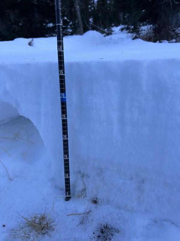
Nowcast- With mostly clear skies overhead, a glowing and growing Cold Moon casts beautiful light on our mountains this morning which proudly display a fresh coat of white paint. While yesterday's storm wasn't exactly a barnburner it did deliver a North Slope favored 8" of snow with just .50" H2O. Unfortunately the south half of the range didn't get the powder party invite until late in the day, couldn't find a fashionable outfit for the affair, and is a bit self conscious to report only about 4" of low density storm storm. Meanwhile near the peaks, northwest winds blow in the 20's and temperatures start the day in the single digits.

Forecast- It'll be a glorious day in the mountains with mostly sunny skies and temperatures climbing into the low to mid 20's. Northerly winds blowing in the 20's along the high ridges will add a bit of a bite to the already crisp air.

Futurecast - Increasing clouds and wind are on tap for Tuesday as another system, similar to this past weekend's storm, slides into the region. A warmer, potentially wetter storm is on tap to round out the work week.

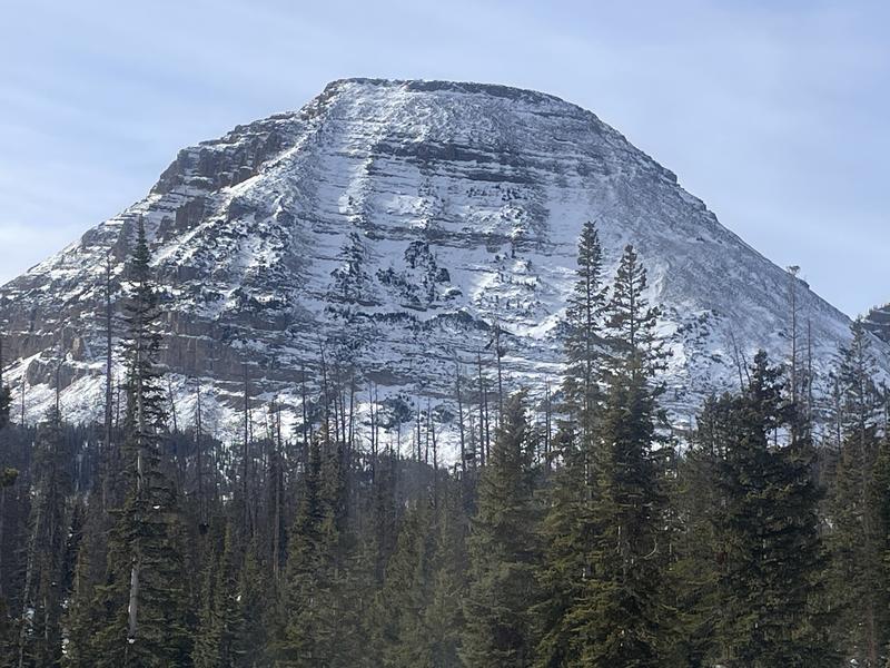
A little lean, but it's obvious Bald Mountain has been to the gym recently and those broad, well defined shoulders reflect the effort :)

Recent Avalanches

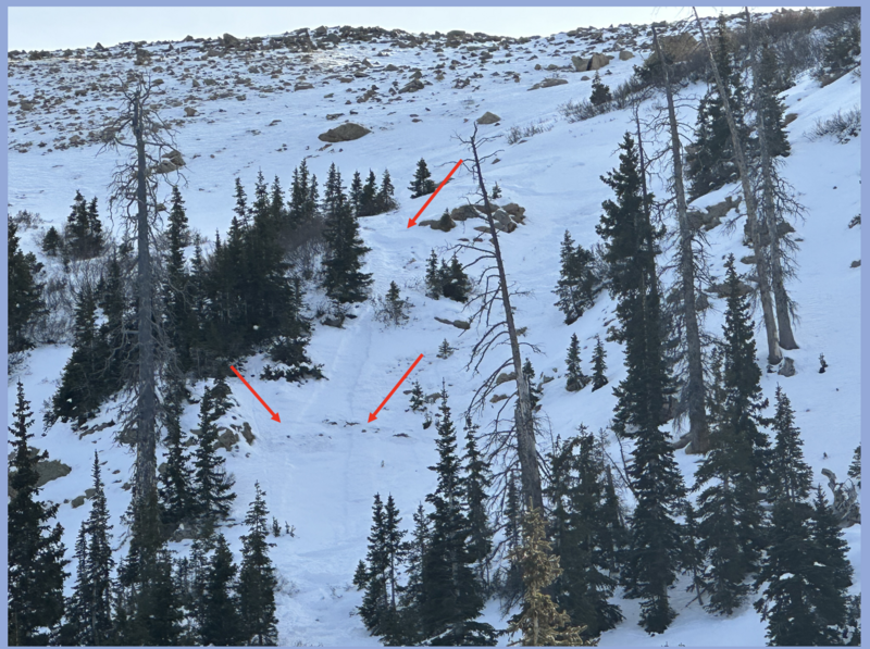
Prior to yesterday's storm a handful of folks were tagging roadside attractions near Bald Mountain Pass, with one recently triggered facet-lanche spotted on a steep, rocky, breakover in Murdock Bowl.

Avalanche Problem #1
Wind Drifted Snow
Type
Location
Likelihood
Size
Description

Yesterday's storm snow conspired with strong west and southwest winds, forming dense drifts that'll react to our additional weight. The good news is... the hazard is pretty straight-forward and confined to steep, shady, upper elevation terrain, especially slopes that harbor early season snow. The bad news... those are the exact slopes we'll be lured into today because that's where the best coverage is found. But here's the problem... any slide triggered is gonna fail on snow that grew weak and sugary during the November dryspell and that means today's avalanches will break a little deeper and wider than you might expect. The badder news... even a relatively small slide will reveal a myriad of season ending obstacles like stumps and rocks, barely hidden underneath the thin veneer of an early season snowpack.

I know you wanna avoid avalanches so here's your exit strategy and hall-pass for the day. First, get out an enjoy the beautiful weather and fresh snow! Second, stretch out the legs on low angle meadows or take the sled for a quick road rip. And finally, while you're out and about do a little snowpack CSI, dig a snowpit to see what we're dealing with, and map out the lay of the land. It'll give you a better sense for the type of terrain you can ride safely once it does start storming and the slopes you'll need to avoid.

Click HERE for a viddy of my stomp around Bald Mountain Pass on Saturday.

Additional Information

Prior to the weekend storm, Ted got some eyes on Double Hill and reports spotty, shallow, and generally weak snow prevailing on the mid and upper elevation shady's. A midpack raincrust is the only notable body in the snowpack structure near Gold Hill.

Pit profile and an ob from a crew I bumped into Saturday in the Murdock Bowl zone... thanks for the beta and the high fives!

General Announcements

We are always looking for snow and avalanche observations or just general riding conditions. Reach out to us with questions, concerns, or if you see anything in your travels! Contact us directly through the info below:

This forecast is from the U.S.D.A. Forest Service, which is solely responsible for its content. This forecast describes general avalanche conditions, and local variations always occur. This forecast was issued on Monday, December `1st at 04:30 AM and expires 24 hours after it was issued.