Sign Up for the Utah Snow and Avalanche Workshop (USAW) on December 7th!

Forecast for the Uintas Area Mountains

Craig Gordon
Issued by Craig Gordon on
Wednesday morning, November 6, 2024
Updated Wednesday November 6th at 04:00
We had a nice little shot of snow to kick off the week, but winter is still finding its footing. With snow depths averaging 12"-16" there's hardly enough snow to move around on without slamming into a rock or a stump. And even though there's barely enough snow to ride... there's is enough snow to slide. While road side attractions off the Mirror Lake Highway or Wolf Creek Pass might look enticing and you'd really have to go out of your way to trigger an avalanche, remember... even a small slide would result in an instant season ending injury.
In the meantime, thanks for checking in and stay tuned... we’ll issue updates as conditions warrant. Daily forecasts and danger ratings are weather dependent, though often start in early December. Current conditions report down below from the weather desk.
But wait... of course there's more! Please join us at one of the many upcoming events found HERE (scroll to the left hand corner near the bottom of our homepage).
Low
Moderate
Considerable
High
Extreme
Learn how to read the forecast here
Special Announcements
Huge thanks to nearly 500 avy professionals from around the state for taking time out of their busy lives and devoting so much of themselves to attend and present at this years 17th annual pro avalanche workshop... PROSAW.
Be sure to check out the equally high quality public USAW session at the University of Utah on Saturday, December 7th - Information and tickets available here.
Weather and Snow
Nowcast- Yesterday's storm delivered a thin coat of white paint... just about 5" of snow with around .35" H2O. In other words... lean and light. Skies are clearing as a cold northerly flow ushers the storm to the east. It'll feel like winter with temperatures in the teens at the trailheads and single digits along the high ridges. Throw in northeast winds blowing 15-20 mph and we've got finger numbing windchill registering to -15 degrees in the high country.
Forecast- Skies clear as the day hits its stride, while northeast winds blow 15-25 mph near the high peaks. It'll be a crisp one with high temperatures barely cracking into the low 20's as overnight temperatures crater in the single digits.
Futurecast- Not a lot going on in the weather department... perhaps a weak system grazes northern Utah Sunday, with a more promising storm materializing early next week.
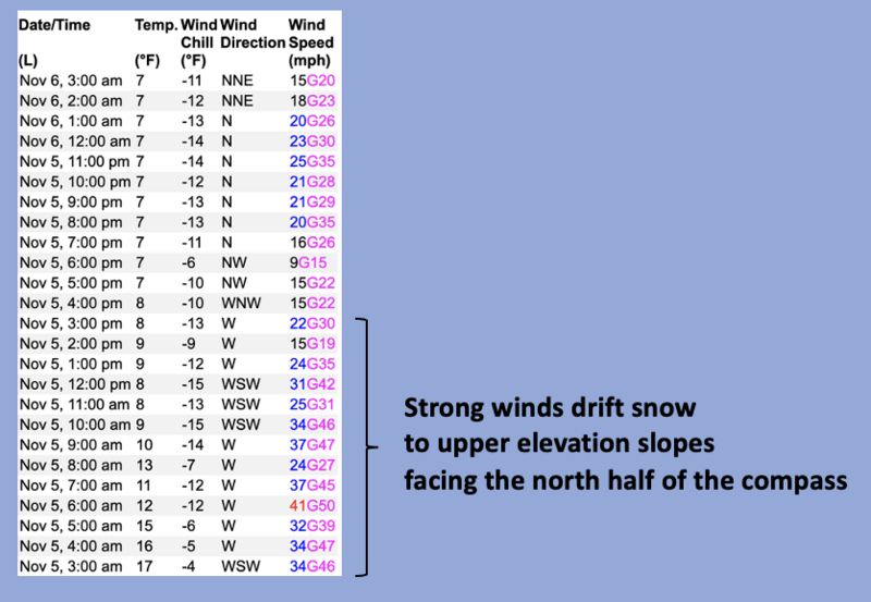
Above is a 24 hour wind run from Windy Peak (10,662')
Recent Avalanches
No avy activity observed or reported
Ad
Additional Information
The Uinta weather station network was upgraded this summer and all that real-time info is found HERE. Simply click on "western Uinta" tab and then "weather stations" tab.

We are always looking for snow and avalanche observations or just general riding conditions. So... if you see something, say something. You can reach me directly at craig@utahavalanchecenter.org or 801-231-2170.
Also, if you're looking for more avy education opportunities for yourself, your crew, or your club please don't hesitate to reach out to me and we'll find a presentation, class, or clinic for ya!
General Announcements
Issued on Wednesday, November 6th at 04:00, this forecast expires 24 hours after the date and time issues, but will be updated this week as conditions change!
This forecast is from the U.S.D.A. Forest Service, which is solely responsible for its content. This forecast describes general avalanche conditions and local variations always occur.