Join us at our 2nd Annual Blizzard Ball

Forecast for the Uintas Area Mountains

Craig Gordon
Issued by Craig Gordon on
Friday morning, January 3, 2025
The snowpack might feel solid and bomber underneath us, but remember... it's still in its teenage years, it's wound up tightly, and it's moody and unpredictable-
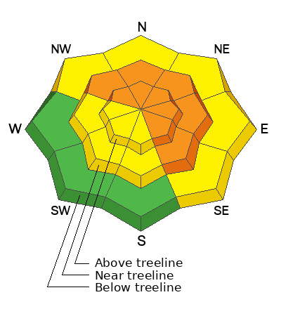
At and above treeline, you'll find CONSIDERABLE avalanche danger today. Deep, dangerous, and potentially unsurvivable human triggered avalanches are LIKELY particularly on steep, leeward slopes in the wind zone, and especially in terrain with an easterly component to its aspect. Today’s avalanches will break deeper and wider than you might expect and they'll pack a powerful, season ending, machine vaporizing punch.
Mid and upper elevation terrain facing the south half of the compass (solars) along with lower elevation shady slopes (polars) offer MODERATE avy danger. While a bit more predictable, human triggered avalanches are still POSSIBLE on steep, wind drifted slopes.
Generally LOW avalanche danger exists in terrain facing the south half of the compass at lower elevations near the trailheads... now there's your exit strategy if you're not feeling confident with the avy danger!
Low
Moderate
Considerable
High
Extreme
Learn how to read the forecast here
Special Announcements
We are deeply saddened to confirm two avalanche fatalities. The first involved a 38 year old man in Main Porter Fork of Mill Creek Canyon who went missing on Saturday. The second avalanche fatality occurred Tuesday and involved a 54 year old man off Davenport Hill into Silver Fork of BCC. Both individuals were traveling alone in the backcountry. Please know, our hearts are heavy for the family and friends of these gentlemen.
Many thanks to those who responded to these accidents: search and rescue teams from AirMed, LifeFlight, Utah Dept Public Safety, Utah Department of Transportation, Salt Lake County Search and Rescue, Wasatch Backcountry Rescue, Alta Ski Area, and members of the Utah Avalanche Center.
Weather and Snow
Nowcast- Brief high pressure visits the Beehive state for a hot minute, but someone left the storm door open and the next system is the queue, slated to arrive early Saturday morning. In the mean time, skies are partly cloudy and temperatures register in the low to mid 20's. Southerly winds took a break to catch last night's evening news, but were back at overnight and early this morning, blowing in the 20's and 30's near the high peaks. With a mostly supportable base underfoot, riding and turning conditions turned from zero to hero in just four days.
Forecast- Look for increasing clouds with record setting temperatures climbing into the low 40's. Gusty southwest winds develop late in the day, ramping into the 40's and 50's by about dinnertime.
Futurecast- A rowdy lookin' cold front slides into the eastern front early Saturday morning, delivering much colder temperatures and a solid shot of snow. I'm cautiously optimistic we'll stack up a foot of snow by days end. Snow showers linger into Sunday morning, a brief break midday through Sunday night, and then another system slated for Monday.
Recent Avalanches
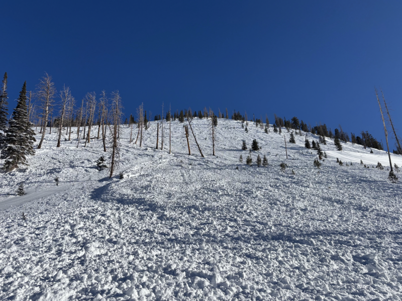
Above is an image of a very well-connected avalanche on the east side of the range near the Boundary Creek yurt that slid during the New Years Eve storm cycle. A group spending the night in the yurt commented... "In the morning of the 31st we saw that the steep west/northwest facing slope just south of the yurt avalanched overnight. It ran full length of the path, missing the Boundary Creek Yurt by 200 feet." Yikes!
From Strawberry Rez to Evanston, an aerial view of the postage stamp revealed the affirmation that 2025 got the party started early and went out with a bang. Of note, a widespread avy cycle in the likely suspects, but also unsuspecting slopes like treed terrain and mid slope pockets, particularly on the south half of the range which tipped the scales with 3" SWE. Uinta avy obs are found here.
Huge thanks to everyone for helping us out by providing very timely observations, insight, and honesty. Remember... your intel helps save lives, so please keep the info rollin' in! All those obs and trip reports along with info from neighboring Utah forecast zones are found here.
Ad
Avalanche Problem #1
Persistent Weak Layer
Type
Location
Likelihood
Size
Description
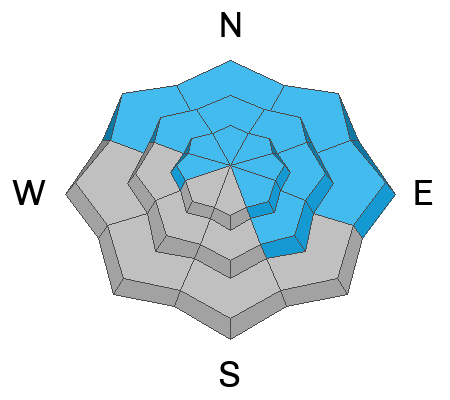
Joey and I stomped around lower Weber Canyon yesterday and experienced a solid feeling snowpack underfoot, though the reveal is under the hood... the December drought layer is very concerning. After collapsing a lower elevation northeast facing slope we performed a snow stability test that produced a score of 24 out of 30 suggesting the snow is gaining strength and it's becoming harder to trigger an avalanche but there's still alot of stored energy in the slab. So what does all this avalanche geek-speak mean?
While the sensitivity of today's avalanches might've calmed down slightly, the consequences of triggering a slide remain severe. Here's where it gets tricky... terrain that already avalanched during last weekends storm doesn't present that fresh, recent avalanche look or showroom smell. In fact, most of the evidence of recent avalanche activity is now blown back in and camouflaged by fresh snow. Problem is... any slope that didn't avalanche, waits for us to roll along and knock the legs out from underneath. If you're on the receiving end, today's avalanches are gonna be meaty, pack a devastating punch, and will instantly ruin your day, as well as those waiting for you at home.
Avalanche Problem #2
Wind Drifted Snow
Type
Location
Likelihood
Size
Description
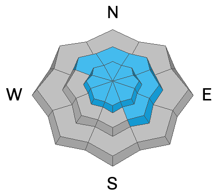
Warm temperatures may limit the amount of snow available to blow around, but today's strong winds will whip up a fresh round of shallow drifts that'll react to our additional weight. Found mostly on the leeward side of upper elevation ridges, I wouldn't be too surprised to find a fresh drift of two lurking around a terrain feature like a chute or gully wall. In either case, my strategy is... I'm simply avoiding fat rounded pieces of snow, especially if they sound hollow like a drum. And remember, fresh wind drifts aren't always a manageable avalanche problem. Once triggered, today's drifts can get out of hand quickly if they break into faceted weak layers, now buried several feet deep in the snowpack.
Additional Information
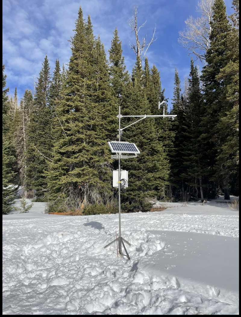
The Mill Hollow snow site is up and running! Current data is found here.
General Announcements
The Uinta weather station network was upgraded this summer and all that real-time info is found here. Simply click on the "Western Uinta" tab and then the "Weather Stations" tab to find all your weather needs.
We are always looking for snow and avalanche observations or just general riding conditions. So... if you see something, say something. You can reach our team directly by contacting: Craig at craig@utahavalanchecenter.org, 801-231-2170, or Andrew at andy@utahavalanchecenter.org, or 860-460-8142.
General Information
This forecast is from the U.S.D.A. Forest Service, which is solely responsible for its content. This forecast describes general avalanche conditions and local variations always occur. This forecast was issued on Friday, January 3rd at 04:00AM and expires 24 hours after it was issued. We will update the forecast by 0700 AM tomorrow. But, in the meantime reach out to us with questions, or if you see anything in your travels.