Join us at our 2nd Annual Blizzard Ball

Forecast for the Uintas Area Mountains

Craig Gordon
Issued by Craig Gordon on
Friday morning, January 24, 2025
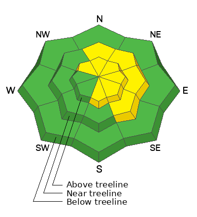
Pockety MODERATE avalanche danger is found on steep, wind-drifted, mid and upper-elevation terrain, particularly slopes with an easterly component to their orientation where human triggered avalanches are POSSIBLE. While becoming more the exception than the rule, any slide initiated in steep, rocky terrain facing the north half of the compass, may fail on weak, sugary, faceted snow, delivering a deeper and wider slide than we might've bargained for.
Out of the wind-zone, LOW avalanche danger exists on all other aspects and elevations, but riding conditions are a hit or miss, mixed bag of snow surface conditions.
Low
Moderate
Considerable
High
Extreme
Learn how to read the forecast here
Special Announcements
Urgent battery replacement required for anyone who received batteries from one of our participating "Batteries for Beacons" shops. Please review the "Batteries for Beacons" replacement notice on our blog. Batteries distributed through our "Batteries for Beacons" program this year have shown to be inadequate length.
  • Please join the UAC at Deer Valley on January 30th for the 2nd Annual Blizzard Ball Gala. The night will be full of fun including delicious cuisine, live music, an auction, and presentation by Bruce Tremper. More info found here.
Weather and Snow
Nowcast- As the jury deliberates on the verdict of the next storm, high clouds drift into the Uinta zone and temperatures crawl out of the ice box and into the mid teens... nearly 20 degrees warmer than yesterday at this time. The high peaks answer the roll call with southwest winds humming along in the 20's and 30's. Riding and turning conditions are a mixed bag and a down day might be in order even if it means organizing the garage. So, get your chores done today and wait for tomorrows shallow coat of white paint that'll add a bit of cushion to rutted out, hard, old snow surfaces.
Forecast- Look for increasing clouds with west and southwest winds bumping into the 40's as the day ares on. Compared to our recent streak, today's high temperatures climbing into the upper 20's will feel downright tropical. A chance of light snow develops later this afternoon, with snow becoming more widespread Saturday morning as a cold front stalls over the area.
Futurecast- Still much uncertainty remains with the weekend storm system including its track, timing, and potential for accumulating snow, but 2"-4" by Saturday morning seems reasonable... stay tuned.
Ted was in the Whitney Basin environs Wednesday and got eyes on Double Hill, noting... "Strong winds worked a lot of the exposed terrain, but there is some nice dense settled snow in sheltered areas that did not get the wind. Some of the south facing slopes developed a heat crust from the warmer temperatures yesterday."
Recent Avalanches
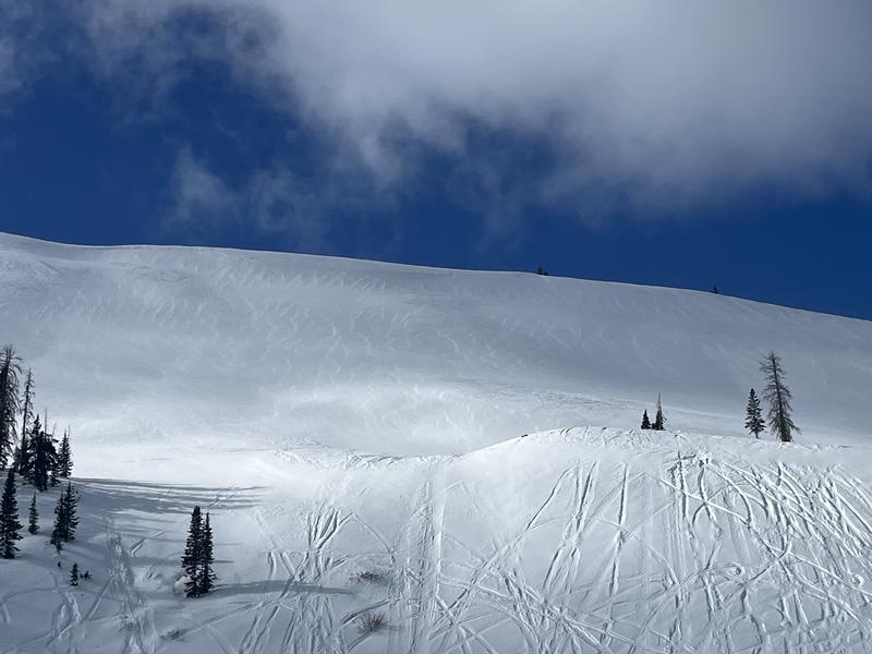
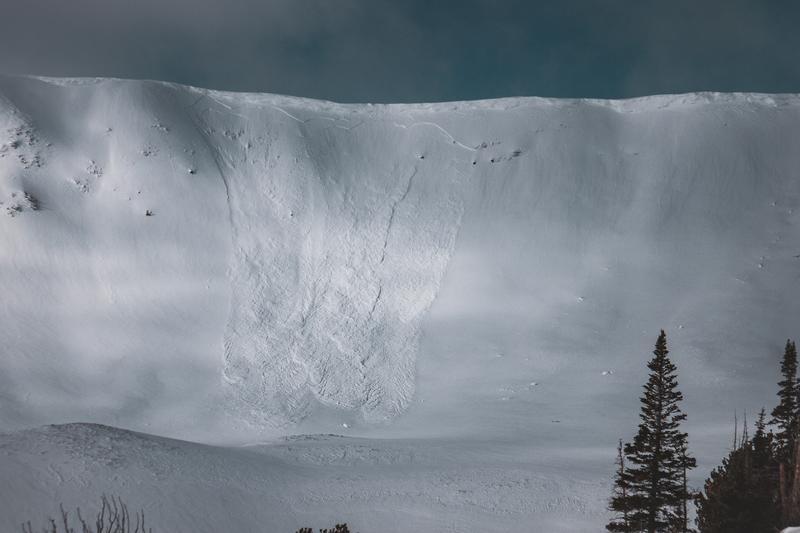
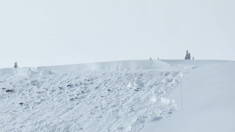
A result of fierce, northerly, midweek winds... a shallow, yet well connected natural avalanche in the image above was reported Wednesday on a steep, southeast facing slope in the wind zone of Upper Weber Canyon.
You can find trip reports and recent slides from across the range and beyond, here.
Ad
Avalanche Problem #1
Wind Drifted Snow
Type
Location
Likelihood
Size
Description
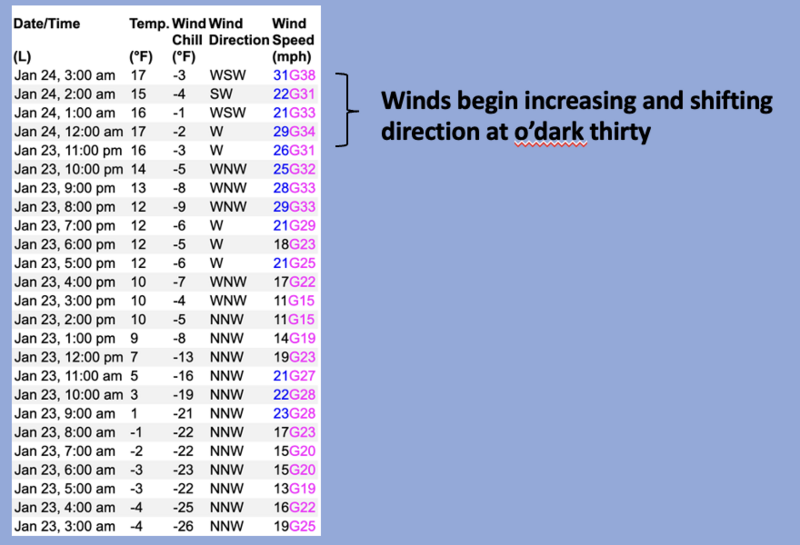
Above, a 24 hour wind run from Windy Peak (10,662') illustrating a shift in wind direction and a bump in temperatures.
Winds have blown for days, whipping up several batches of dense, hard slabs on upper elevation leeward slopes. Unfortunately, recent drifts will feel solid under our skis, board, or sled and allow us to get well out on slope before breaking above us and have the potential to step down into deeper layers of the snowpack.
Today's drifts are a mostly manageable and straight-forward avalanche problem with proper terrain choices and travel techniques. Choose clean slope run outs with less severe consequences like cliffs, rocks, or terrain traps and travel mindfully by exposing only one person at a time to the potential hazard.
Avalanche Problem #2
Persistent Weak Layer
Type
Location
Likelihood
Size
Description
The last reported avalanche failing on our now mostly dormant problem child, the Persistent Weak Layer (PWL) formed during the December drought, was over a week ago on Sunday, January 12th. Good news is the snowpack has slowly gotten comfortable in its own skin. The tricky part is... while the likelihood of triggering a nasty persistent slab avalanche has gone down significantly over the past few weeks, the consequences remain severe if we do.
How do we manage an unmanageable avalanche dragon? All the snow-pros I knows, are avoiding the usual suspect slopes... steep, rocky, mid and upper elevation terrain, especially where the pack is slightly thinner. And remember... thin spots are potential trigger points and exist near bushes, rocks, or steep rollovers.
General Announcements
The Uinta weather station network was upgraded this summer and all that real-time info is found here. Simply click on the "Western Uinta" tab and then the "Weather Stations" tab to find all your weather needs.
We are always looking for snow and avalanche observations or just general riding conditions. So... if you see something, say something. You can reach our team directly by contacting: Craig at craig@utahavalanchecenter.org, 801-231-2170, or Andrew at andy@utahavalanchecenter.org, or 860-460-8142.
General Information
This forecast is from the U.S.D.A. Forest Service, which is solely responsible for its content. This forecast describes general avalanche conditions and local variations always occur. This forecast was issued on Friday, January 24th at 04:00AM and expires 24 hours after it was issued. We will update the forecast by 0700 AM tomorrow. But, in the meantime reach out to us with questions, or if you see anything in your travels.