Forecast for the Skyline Area Mountains

Brett Kobernik
Issued by Brett Kobernik on
Sunday morning, April 3, 2022
The majority of the terrain on the Manti Skyline has a LOW avalanche danger.
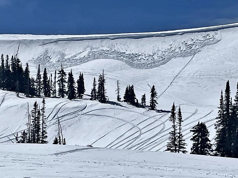
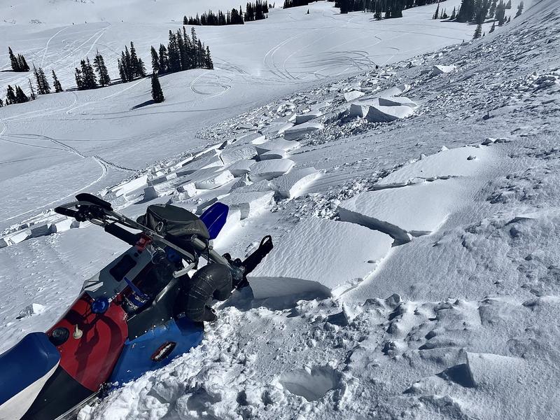
However, a CONSIDERABLE danger still exists on slopes steeper than 30 degrees that face northwest, north and northeast above about 10,000'.
Large and dangerous human triggered avalanches are still likely in that terrain.
Low
Moderate
Considerable
High
Extreme
Learn how to read the forecast here
Weather and Snow
Current Conditions
Riding on Saturday was again pretty decent but the warmer weather is certainly taking a toll on the conditions with many slopes becoming quite wet. You'll find melt/freeze crusts this morning. Overnight temperatures were in the mid 20s to around freezing. It was pretty windy Saturday afternoon but the wind really tapered off overnight.
Mountain Weather
It'll be mostly cloudy today with high temperatures around 40˚F. West northwest wind is going to be pretty light. Monday looks partly cloudy with slightly warmer temperatures. A small storm moves in Monday night that should bring 3 to 6 inches of new snow.
Recent Avalanches
It appears that there was a close call with a snowmobile triggered avalanche early Saturday morning or perhaps late Friday afternoon. It was in Jordan Canyon at about 10,400' on a northeast facing slope. It broke 3 to 6 feet deep into the old weak sugary snow that formed in Jan/Feb. It produced a very large pile of debris that was 10 to 15 feet deep. We found a spot on the debris where riders were digging with shovels. This makes me think that someone was caught and partially or fully buried. If you were involved with the avalanche I'd love to talk with you. CONTACT ME HERE I have some questions that will help me give people better information in the future.
There was also a decent sized wind slab triggered by a snowmobiler in Spring Canyon. This involved just the new snow in an area where it had been drifted. It seemed to be an isolated incident.
Ad
Avalanche Problem #1
Persistent Weak Layer
Type
Location
Likelihood
Size
Description
I thought we were done with the Persistent Weak Layer of loose faceted sugary snow that formed in Jan/Feb. I hate to say it but we are not done. Yesterday's avalanche clearly points out that there are still big concerns. The locations where these beasts can still be triggered are very specific:
  • Above 10,000'
  • Northwest, north and northeast facing slopes
  • Slopes steeper than 30 degrees. (to be honest, slopes need to be steeper than 35 degrees to avalanche right now but 30 degrees is the number you should use to stay safe)
If you avoid that terrain, you will not trigger one of these large avalanches.
General Announcements
This forecast is from the U.S.D.A. Forest Service, which is solely responsible for its content. This forecast describes general avalanche conditions and local variations always occur.