Forecast for the Skyline Area Mountains

Brett Kobernik
Issued by Brett Kobernik on
Sunday morning, March 22, 2020
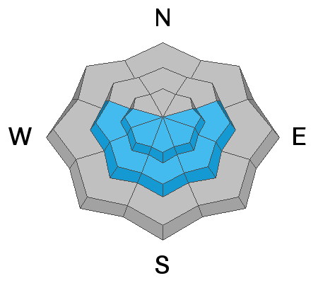
For the most part the avalanche danger is generally LOW but there's the slight potential for small wind drifted snow avalanches as well as wet snow avalanches today. I've increased the danger slightly to indicate a MODERATE avalanche danger for these potential issues.
  1. Watch for any cracking within the new snow which indicates sensitive wind drifts
  2. The new snow will most likely become damp today. Move off and out from under steep slopes if the new snow starts getting excessively wet and gloppy.
Low
Moderate
Considerable
High
Extreme
Learn how to read the forecast here
Weather and Snow
Current Conditions: Another 3 to 4 inches of snow fell in the last 24 hours. Once again, the central and southern end of the range did a bit better than the north end. We are up to over a foot of snow since Tuesday. Temperatures were in the mid 20s overnight. Westerly wind has increased overnight and this should be taken into account today. There are a few clouds lingering over the mountains this morning.
Mountain Weather: Cloud cover is going to be a little tricky to predict just how much we'll see over the mountains. It looks like there may be enough moisture hanging around to keep some clouds over the mountains. The moderate speed wind should slow during the day today. We'll see high temperatures in the low to mid 30s up along the ridges
Ad
Avalanche Problem #1
Wind Drifted Snow
Type
Location
Likelihood
Size
Description
The bump in wind speeds over the last 12 hours is really the only change that we've seen that might increase the avalanche danger a bit. Fresh wind drifted snow may have formed some sensitive pockets although I think the likelihood of finding a bunch of these today is low. That said, PAY ATTENTION!! Look for any recent avalanches. Watch for any cracking around your skis, snowboard or machine as you travel today. These are your bullseye clues that things might be sensitive out there today.
Avalanche Problem #2
Wet Snow
Type
Location
Likelihood
Size
Description
The second thing you should keep in mind today is potential wet snow avalanches caused from daytime heating. The new snow will most likely become damp in many locations and if it gets too wet, we may start to see some wet snow avalanche activity especially on the more sunny slopes. If the sun pops out strong during the day today, watch for rollerballs or pinwheels on the snow surface. Sloppy wet snow should also be noted. These are your bullseye clues to potential wet avalanche activity. If you're seeing these things, avoid being on or below steep slopes.
Additional Information
This forecast is from the U.S. Forest Service, which is solely responsible for its content. This forecast describes general avalanche conditions and local variations always occur.