Check out our Holiday Auction - Sign Up for the Utah Snow and Avalanche Workshop (USAW)

Forecast for the Skyline Area Mountains

Brett Kobernik
Issued by Brett Kobernik on
Friday morning, March 15, 2024
The overall avalanche danger rating for the Skyline is MODERATE.
Wind drifted snow is your main concern today.
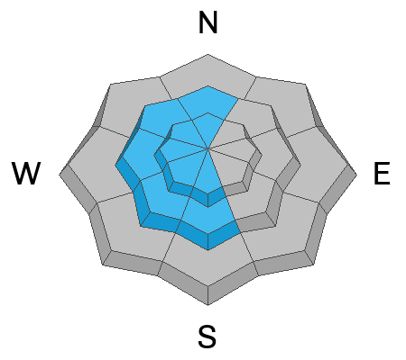
Moderate to strong wind from the east will drift some snow and form slabs that may be sensitive. These drifts and slabs will be in unusual places like on west facing slopes due to the east wind.
Low
Moderate
Considerable
High
Extreme
Learn how to read the forecast here
Weather and Snow
Current Conditions: A couple of inches of snow trickled in here and there over the last 24 hours. Wind speeds picked up on the northern end of the Skyline but stayed in check in the central and southern regions. Temperatures have been in the low to mid 20s. I found skiing and snowmobiling conditions to be excellent on Thursday.
Mountain Weather: Weather models have really backed off on the amount of snow we'll see out of this storm. This doesn't surprise me as storms with an east flow rarely produce much snow on the Skyline. I'm only expecting a few inches of accumulation late this afternoon and this will be on the east side of the range for the most part. The wind looks like it'll pick up and we'll see the strongest speeds this morning then gradually tapering off through the day. It will be from the east. Temperatures will get up to around 30˚F. Saturday looks cloudy with the slight chance for snow.
Ad
Avalanche Problem #1
Wind Drifted Snow
Type
Location
Likelihood
Size
Description
The new snow was stable as far as I could see on Thursday. I did not encounter areas where the wind had drifted snow. I did not see any significant avalanche activity. I did not experience any cracking within the new snow.
That said, strong wind this morning could form fresh drifts and wind slabs that could be sensitive to the weight of a person. The wind direction is from the east which is not the usual wind loading pattern. Watch for fresh drifts in odd places. The simple rule is to avoid steep slopes where these drifts are forming. They will settle and stabilize within a day or two.
General Announcements
This forecast is from the U.S.D.A. Forest Service, which is solely responsible for its content. This forecast describes general avalanche conditions and local variations always occur.