Forecast for the Skyline Area Mountains

Brett Kobernik
Issued by Brett Kobernik on
Saturday morning, March 13, 2021
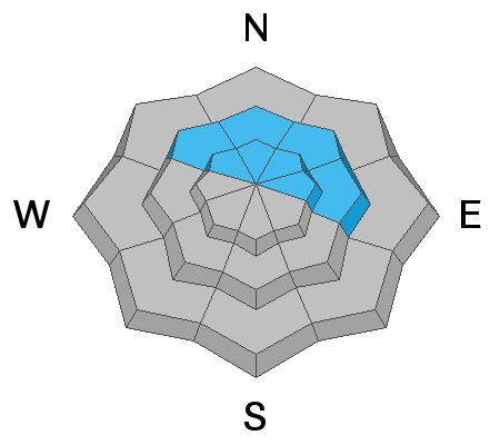
Today the avalanche danger is CONSIDERABLE in the upper elevation northwest through northeast facing steep terrain.
If you happen to trigger an avalanche today it will break to the ground resulting in a large avalanche.
The danger will stay the same or increase on Sunday as a bit more snow is expected with moderate speed northwest wind.
Low
Moderate
Considerable
High
Extreme
Learn how to read the forecast here
Weather and Snow
Current Conditions: Another wave of snow moved through late in the day Friday bringing another 4 inches. Totals since Tuesday are now 10 to 12" containing about .9" of water weight. The flow was from the east and generally light but we did experienced strong enough wind to drift some snow. Riding conditions are pretty good. East wind was pretty light overnight and temperatures are again in the mid teens.
Mountain Weather: The large storm that's been affecting our area since Tuesday has been interesting and challenging for me to forecast. Admittedly, timing of these waves of snow and amounts haven't always matched what I was thinking but the end result looks like it will pan out about as weather models suggested with a total of over a foot of snow by Sunday. We'll see mostly cloudy skies today with another wave of snow starting this afternoon. The flow will shift around north then northwest. I think we should see another 3 to 6" by Sunday.
Ad
Avalanche Problem #1
Persistent Weak Layer
Type
Location
Likelihood
Size
Description
Out of wind effected areas, the new snow itself is well behaved and is not the concern. The concern with it is the weight it's added on top of our snowpack with a weak base of loose sugary snow near the ground. It looks like we'll end up with over an inch of water weight added this week. Now, this has been added slowly so the pack has had time to adjust between each smaller wave. Also, wind has been generally light and hasn't drifted tons and tons of snow except along higher ridgelines. Many areas have a stout bridge over the weak snow now. But the thing that's most important is the fact that the weak snow is still present and once you break that bridge, a deep avalanche will result. I'm holding my cards tight.