Forecast for the Skyline Area Mountains

Brett Kobernik
Issued by Brett Kobernik on
Thursday morning, March 11, 2021
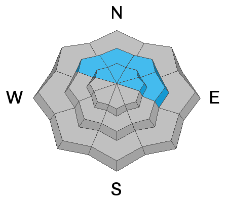
Today the avalanche danger is CONSIDERABLE in the upper elevation northwest through east facing steep terrain.
Human triggered avalanches breaking into weak snow near the ground are possible.
Additional snow over the next few days will continue to increase the avalanche danger.
Low
Moderate
Considerable
High
Extreme
Learn how to read the forecast here
Weather and Snow
Current Conditions: Another 2 to 4 inches of snow accumulated overnight. This brings totals up to 5 to 7 inches since Tuesday. The wind really slowed overnight and is basically calm. Temepratures are in the upper teens.
Mountain Weather: The large closed low pressure system is still working its way south over California and will start to move east through Arizona tomorrow. This system will continue to give us periods of snow through Saturday. For today, expect snow with another 3 to 6 inches possible by Friday morning. Temperatures will be around 20˚F today with light southerly wind. Another period of snow looks like it should occur Friday afternoon then another one early Saturday morning with lingering light snow through Saturday.
Ad
Avalanche Problem #1
Persistent Weak Layer
Type
Location
Likelihood
Size
Description
The weak layers of sugary faceted snow at the base of the snowpack remain a concern. We are now adding stress to those layers again with the new snow that is accumulating. We are adding the snow slowly so it's tricky to say when things will become really dangerous. The wind has been fairly light which is a good thing in that it is not rapidly loading slopes with snow.
The bottom line is you can't mess around with a known buried Persistent Weak Layer of faceted snow. This stuff will bite you when you're not expecting it.