Forecast for the Skyline Area Mountains

Brett Kobernik
Issued by Brett Kobernik on
Friday morning, February 7, 2020
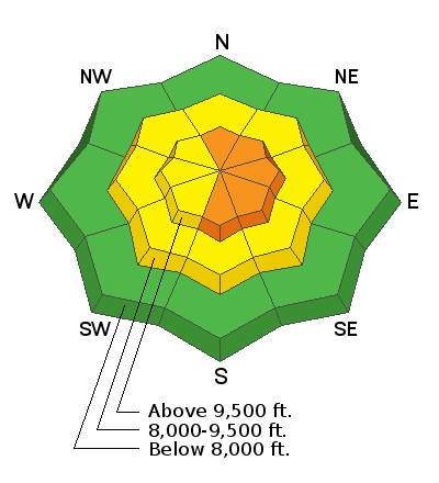
The avalanche danger is CONSIDERABLE along the higher steep more east facing terrain. This is where a person is most likely to trigger an avalanche today. However, the mountains channel wind in all sorts of directions and we'll most likely see fresh drifts and wind slabs that have formed on many different aspects. Where the wind has not been drifting snow as much, the avalanche danger is much lower.
IT'S POSSIBLE THAT THE FRESH DRIFTS MAY STILL BE SENSITIVE ON SATURDAY WHEN MORE PEOPLE WILL BE IN THE MOUNTAINS.
Low
Moderate
Considerable
High
Extreme
Learn how to read the forecast here
Weather and Snow
Current Conditions: Snow totals are difficult to decipher because of all the wind drifting the new snow. As best as I can tell, we've received about 4 to 5 inches of very dense snow which contains about an inch of water. This dense high density snow landed on top of low density snow from earlier this week. This give the snow an "upside down" feel to it. The strong west wind is a major consideration. It was very gusty on Thursday and looks like it will continue to blow in the moderate to strong range today. Mountain temperatures have been in the mid 20s.
Mountain Weather: We may see a little more snow accumulation this morning, tapering off this afternoon. I'm not expecting more than a few inches. The wind is going to remain fairly strong along the ridgetops from the west and northwest today. We'll have cloudy skies today. The storm moves out this afternoon and evening and we'll see sunshine on Saturday with quite mild temperatures. It looks a little windy on Saturday but it won't be as strong as yesterday and today. Another small storm will move through Sunday which looks like it'll bring a few more inches of snow.
Ad
Avalanche Problem #1
Wind Drifted Snow
Type
Location
Likelihood
Size
Description
Wind drifted snow is a big concern for today and Saturday. During fieldwork on Thursday, I did not get a real good handle on how large the new drifts are or how sensitive they are. It was blowing so much down in the basin we were in that we couldn't really see much and didn't feel comfortable getting into higher terrain for assessment. What I do know is that we noted that drifting was occurring where we were at 9600' and it can only be more pronounced up higher. It looks like the wind will continue to blow today. It's not a good day today to mess around with steep slopes in the upper elevations where these drifts are likely to crack out on you.
Additional Information
This forecast is from the U.S. Forest Service, which is solely responsible for its content. This forecast describes general avalanche conditions and local variations always occur.