Forecast for the Skyline Area Mountains

Brett Kobernik
Issued by Brett Kobernik on
Sunday morning, December 18, 2022
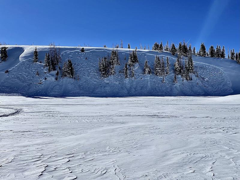
DANGEROUS AVALANCHE CONDITIONS THIS WEEKEND!!
The avalanche danger is rated at CONSIDERABLE again today.
  • Human triggered avalanches 1 to 3 feet deep (or deeper) are likely.
  • Stay off slopes steeper than 30˚.
  • Make sure there is nothing steep above you.
  • Do not travel down in steep gullies and ravines.
Low
Moderate
Considerable
High
Extreme
Learn how to read the forecast here
Special Avalanche Bulletin
DANGEROUS AND UNUSUAL AVALANCHE CONDITIONS WILL LAST THROUGH AT LEAST THIS WEEKEND. HEAVY SNOWFALL THIS PAST WEEK HAS CREATED DANGEROUS AVALANCHE CONDITIONS AT ALL ELEVATIONS. DON'T BE LURED BY THE BEAUTIFUL SUNNY SKIES AND FRESH POWDER INTO THINKING AVALANCHE CONDITIONS ARE SAFE WHEN THEY ARE NOT.
DO NOT TRAVEL ON, UNDERNEATH, OR ADJACENT TO SLOPES 30 DEGREES OR STEEPER ON SLOPES FACING NORTHWEST, NORTH, NORTHEAST, AND EAST WHERE TRIGGERING LARGE AND DANGEROUS AVALANCHES IS LIKELY. THIS INCLUDES LOW-ELEVATION FOOTHILLS WHERE AVALANCHES CAN OCCUR NOT FAR FROM PARKING AREAS AND TRAILHEADS.
Weather and Snow
Current Conditions: Saturday was a spectacular day in the mountains with fresh powder and blue skies. Temperatures got into the mid 20s briefly and dropped back into the teens overnight. A brief period of moderate speed northwest wind early Saturday let up and wind was light for the rest of the day and overnight.
Mountain Weather: We'll see two more days of clear skies with high temperatures in the low 20s and light westerly wind. Clouds move in on Tuesday and we might see a little snowfall on Wednesday night. A few inches of new snow is possible. It looks like more storms lined up for the longer term.
Recent Avalanches
There were more snowmobile triggered avalanches on Saturday. These were on the southern end of the Skyline and they were triggered remotely (from a distance). The riders were not near the steep slopes and no one was caught. DETAILS HERE
Ad
Avalanche Problem #1
Persistent Weak Layer
Type
Location
Likelihood
Size
Description
The November Persistent Weak Layer of sugary facets (DETAILS HERE) showed its cards again on Saturday with the remotely triggered avalanches described above. My partner and I continued to experience collapsing (whumpfing) of the snowpack while traveling on skis. Recent avalanches and collapsing are NOT signs of a stable snowpack. They are actually red flags of avalanche danger. They are bullseye clues that the snowpack is unstable and capable of producing more avalanches. Continue to avoid steep slopes for a while until the snowpack is stable.
General Announcements
This forecast is from the U.S.D.A. Forest Service, which is solely responsible for its content. This forecast describes general avalanche conditions and local variations always occur.