Forecast for the Skyline Area Mountains

Brett Kobernik
Issued by Brett Kobernik on
Saturday morning, December 18, 2021
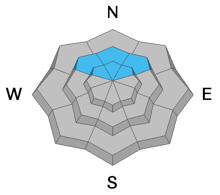
The majority of the terrain on the Manti Skyline has a LOW avalanche danger. However, the danger is CONSIDERABLE on upper elevation steep northwest, north and northeast facing slopes.
The catch is that this upper elevation northerly facing terrain is exactly where we want to go to recreate since this is where the most snow is. Continue to stay on slopes less steep than 30 degrees if you are traveling in this terrain.
Low
Moderate
Considerable
High
Extreme
Learn how to read the forecast here
Special Announcements
Get free batteries for your transceiver and a chance to win 1 of 10 Black Diamond Rescue Kits, 1 of 3 Mammut Barryvox transceivers, or 1 of 3 BCA Tracker transceivers. Stop at Big Pine Sports in Fairview or another participating shop, fill out our survey and get a free set of batteries. Don't need batteries, but still want a chance to win? Simply fill out the survey to be registered.
Weather and Snow
Current Conditions
Riding conditions are quite good right now although we still have a shallow, early season snowpack. Overnight temperatures were in the single digits to low teens. The wind has really slowed and is almost calm.
Mountain Weather
We have a number of nice days ahead of us with plenty of sun and mild temperatures. The next storms are scheduled to start moving through late Wednesday. As of now, it looks like a progressive weather pattern will bring a pretty good amount of snow through the end of December.
Recent Avalanches
No avalanche activity was reported on the Manti Skyline this week but there was plenty of collapsing and cracking. There was a very close call in the Salt Lake area mountains on Friday. Those mountains have a similar buried persistent weak layer like the Skyline does. DETAILS HERE.
Ad
Avalanche Problem #1
Persistent Weak Layer
Type
Location
Likelihood
Size
Description
Snowfall in October hung around on upper northwest, north and northeast facing slopes through a very dry November. The snow deteriorated during this time and formed a layer of loose sugary "faceted" snow. It is now buried with all the snow from the last few weeks. It is known to have produced at least minor natural slab avalanche activity. There have been many reports of the snowpack collapsing or "whoomping" underneath people as well as shooting cracks around them. All of this info tells us we are dealing with a buried "Persistent Weak Layer". This set up is likely to cause more avalanches over the next few weeks. You're only effective mitigation technique is avoidance. Avoid slopes over 30 degrees in steepness that are above 9000 feet and face northwest, north or northeast and you will stay out of avalanches.