UDOT PLANNED AVALANCHE CLOSURES!!

Forecast for the Skyline Area Mountains

Brett Kobernik
Issued by Brett Kobernik on
Wednesday morning, December 11, 2024
The avalanche danger on the Manti Skyline is rated MODERATE.
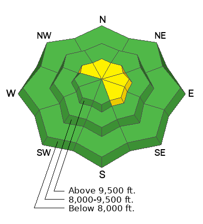
Your biggest concern is in areas where the wind has blown and deposited snow forming drifts and slabs. These may still be sensitive to people today.
The most likely places to trigger one of these is right below the ridgelines especially on the more east and northeast facing steep slopes.
Low
Moderate
Considerable
High
Extreme
Learn how to read the forecast here
Weather and Snow
Current Conditions: Sgt Jayson Albee and I went up Ephraim Canyon late Tuesday to measure snow totals from Monday's storm. I was a little suspicious of the weather station reporting 9 inches. Wind had scattered the snow. Some areas had only a few inches of new snow on the surface and other areas had drifts up to 2 feet deep. After measuring in a few areas we felt were not disturbed by the wind, we agreed that 9 inches was a good measurement. We did not notice much wind while we were up. Wind speeds still look light to moderate this morning but are a little more from the southwest. Temperatures are a bit warmer today with many stations right around 20˚F.
Mountain Weather: Today starts out pretty nice, then I think we'll see some high clouds moving in mid-day. Temperatures will get up to around 30˚F and wind will continue in the light to moderate speed category from the southwest. Another small storm moving through Thursday-Friday could bring a few more inches of snow. Overall, the weather pattern looks unsettled with some small storms rolling through over the next week.
Ad
Avalanche Problem #1
Wind Drifted Snow
Type
Location
Likelihood
Size
Description
Wind drifted snow was quite obvious to Albee and myself while we were up in the hills on Tuesday. These fresh drifts are your main concern. Avoidance is the key.
Often the fresh drifts stabilize rather quickly. However, some of these formed on top of old weak faceted snow. In this situation, they can remain unstable for much longer and it's difficult to determine whether they've formed on top of faceted snow or not. The most likely place to find trouble is right along the ridgelines on steep east and northeast facing terrain. These won't be monster avalanches but could be large enough to "boss you around".
General Announcements
This forecast is from the U.S.D.A. Forest Service, which is solely responsible for its content. This forecast describes general avalanche conditions and local variations always occur.