
Forecast for the Skyline Area Mountains

Issued by Brett Kobernik on
Sunday morning, January 16, 2022
Sunday morning, January 16, 2022
The majority of the terrain on the Manti Skyline has a LOW avalanche danger.
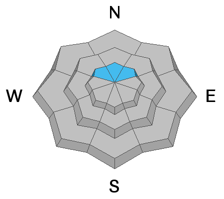
There is a MODERATE avalanche danger in isolated locations where there is a slight chance a person could trigger an avalanche that breaks into old sugary snow near the ground. Very steep slopes in shallow snowpack locations on the north half of the compass would be where you'd find trouble.

Low
Moderate
Considerable
High
Extreme
Learn how to read the forecast here
 Weather and Snow
Current Conditions
Mild weather continues. Temperatures in the higher terrain got into the mid 30s on Saturday with calm to light wind. There is a distinct temperature inversion again this morning with valleys and canyon bottoms colder than up on the peaks. Temperatures in the higher terrain are hovering around freezing. Northwest wind has bumped up in speed slightly along the higher terrain.
Riding conditions are still decent on the north half of the compass with dense creamy powder and some "re-crystalized" snow starting to form. "Re-crystalized" is another term for "near surface faceting". Some people call this "loud powder" as it makes a "swooshing" noise when you ride through it. We are now starting to see the effects of the near surface faceting process in some locations. In simple terms, the dry weather we've had over the last week has turned the snow surface into small grains of granular sugary snow in areas scattered along the Skyline. This process will continue until we see more snow and we will want to pay close attention to what the condition of the snow surface is like before the next storms, whenever that will be.
Mountain Weather
High pressure continues to dominate and looks like it will do so for at least another week. Mild weather will continue. Today we'll see high temperatures into the mid 30s. Skies should be mostly clear although we may see some thin higher clouds move through. Northwest wind speeds look slightly stronger than on Saturday with moderate speeds along the higher terrain today. No significant storms are in sight.

Avalanche Problem #1
Persistent Weak Layer
Type
Location
Likelihood
Size
Description
During fieldwork on Saturday I found mostly stable conditions in areas I traveled around Lake Fork near State Road 31. The mid and upper portions of the snowpack are very strong and supportable. In the places I looked at the old faceted snow near the base, I found it has gained a good amount of strength compared to two weeks ago. Snow pit tests produced either non-reactive results or very stubborn results. It was difficult to get the weak layer to fail and propagate across a column of snow.
At this point it seems pretty unlikely that a person will trigger an avalanche that breaks into old weak snow near the ground. There are probably isolated areas where you could find trouble. These would be VERY steep slopes on the north half of the compass in areas with shallow snowpack depths of less than 4 feet total.
Persistent Weak Layer Summary, 2021-2022:
There was a foot or more of snow that fell in October.
This snow melted away on many slopes but it stayed on northwest, north and northeast facing slopes above about 8500'.
The snow that stayed turned into a weak sugary layer during dry weather in November.
We saw a large amount of snow in December which landed on top of the weak snow from October.
The weak layer of sugary faceted snow collapsed and produced avalanches under the stress of the large storms.
The weak layer is still present but has gained some strength.
Snow pit tests are either non-reactive or are very stubborn to get failure and full propagation.
Additional Information
General Announcements
This forecast is from the U.S.D.A. Forest Service, which is solely responsible for its content. This forecast describes general avalanche conditions and local variations always occur.