

Forecast for the Skyline Area Mountains

Issued by Brett Kobernik on
Friday morning, January 14, 2022
Friday morning, January 14, 2022
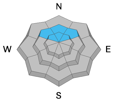
The majority of the terrain on the Manti Skyline has a LOW avalanche danger.
A MODERATE avalanche danger still exists on very steep slopes on the north half of the compass, especially in areas where the snowpack is less than about 4 feet deep. Human triggered avalanches are fairly unlikely but they would be quite severe if you did trigger one.

Low
Moderate
Considerable
High
Extreme
Learn how to read the forecast here
 Weather and Snow
Current Conditions
After high temperatures into the mid 40s along the ridgelines, temps have dropped off into the low 20s and upper teens. Northwest wind picked up overnight and is moderate in speed along the higher terrain. This doesn't look like a real significant wind event and it appears the wind isn't getting down into the canyons too much. Riding conditions remain good in untracked snow especially out of sun affected terrain. The snow surface is dense powder in areas that haven't been hit by direct sun.
Mountain Weather
We'll see mostly clear skies with high temperatures in the upper 20s and north wind slowing as the day goes on. This weather pattern will continue for the foreseeable future. The long term looks bleak for any snow storms. There is literally nothing being advertised in the weather models through the end of the month. The only hope is that often weather models aren't that good at predicting patters further than about a week out. Let's hope that this is the case and we start seeing hints in a pattern change soon.

Avalanche Problem #1
Persistent Weak Layer
Type
Location
Likelihood
Size
Description
The big question on my mind is "will the old weak snow near the ground produce any more avalanches?" I want to say that we may not have to worry about the old weak snow anymore but I still have a little doubt.
The Good:
- We have not seen any avalanches for two weeks now.
- All the snow from December has turned into a VERY strong structure. The layers are very dense and supportable.
- In deeper locations where the snowpack is about 6 feet deep, the old weak sugary facets have gained some strength and are not as loose as they once were.
- Snow pit stability tests produce stubborn results. It is difficult to make things fail.
The Bad:
- In shallower locations where the snowpack is less than about 4 feet, the old sugary facets have only gained a little strength and remain somewhat loose.
- In shallower locations, snow pit stability tests still will produce clean shears (full propagation) through the weak layer.
So, this is my take at the current time. With a very strong mid and upper snowpack structure and some strengthening of the old weak sugary snow, it seems fairly unlikely that a person will trigger something that breaks into old snow near the ground. What troubles me is that the old snow is still fairly loose in shallower locations and it is still shearing clean in snow pit tests. It appears we have entered a period where the old weak sugary snow is "dormant". In other words, it's still there but isn't causing problems currently.
Persistent Weak Layer Summary, 2021-2022:
There was a foot or more of snow that fell in October.
This snow melted away on many slopes but it stayed on northwest, north and northeast facing slopes above about 8500'.
The snow that stayed turned into a weak sugary layer during dry weather in November.
We saw a large amount of snow in December which landed on top of the weak snow from October.
The weak layer of sugary faceted snow collapsed and produced avalanches under the stress of the large storms.
The weak layer is still present but has gained some strength. We are monitoring it and are hopeful it will become more stable with time.
Additional Information
General Announcements
This forecast is from the U.S.D.A. Forest Service, which is solely responsible for its content. This forecast describes general avalanche conditions and local variations always occur.