Forecast for the Salt Lake Area Mountains

Dave Kelly
Issued by Dave Kelly on
Sunday morning, February 16, 2025
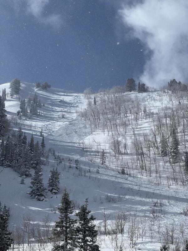
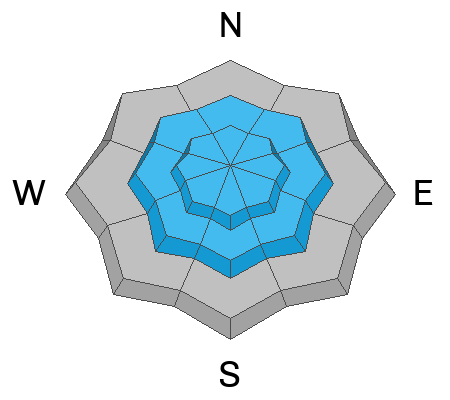
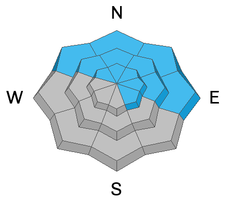
The avalanche danger is HIGH on mid and upper elevation slopes where it is very likely that you will trigger a new or wind-drifted snow avalanche failing on one of many buried weak layers. These avalanches will be deep enough to bury, injure, or kill a person. The avalanche danger is CONSIDERABLE at lower elevations.
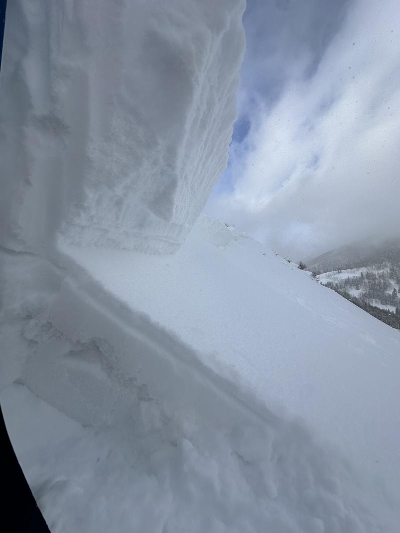
What makes this snowpack complex is trying to outsmart it. If I respect it and give it time then things will change. Until then, lower angle terrain has great coverage and soft surface conditions are everywhere on slopes under 30°.
Low
Moderate
Considerable
High
Extreme
Learn how to read the forecast here
Avalanche Warning
What: The avalanche danger for the warning area is HIGH
When: In effect from 6am MST this morning to 6am MST Monday
Where: For the mountains of Utah, including the Wasatch Range, Uinta Mountains, Wasatch Plateau, Manti Skyline, the Abajos, the Tushar Range....
Impacts: Heavy snow and drifting by strong winds have created widespread areas of unstable snow and very dangerous avalanche conditions at all elevations. Natural and human-triggered avalanches are very likely. People should avoid travel in all avalanche terrain and keep out of avalanche runouts. Avoid being on or under terrain steeper than 30 degrees.
Warning Times: Sunday, February 16, 2025 - 6:00am to Monday, February 17, 2025 - 6:00am
Special Announcements
In the last two weeks we have had two avalanche fatalities. Both reports are now available on our website, February 8th's avalanche in the East Bowl of Silver Fork can be found (HERE) and the report for the February 3rd avalanche fatality on Monte Cristo (Ogden Mountains) is (HERE).
Weather and Snow
Currently, under partly cloudy skies temperatures are in the mid-teens °F. Winds are blowing from the southwest in the teens gusting to the 20's at the lower ridgelines and from the northwest in the 50's gusting to the 60's MPH at the highest ridgelines.
Today, look for partly cloudy skies with increasing clouds and a chance of 1"-3" of snow and up to .3" of water. Temperatures will be 28-32 °F and winds will blow from the west 10 gusting to 20MPH at the lower ridgelines and 35 gusting to 50 MPH at the higher ridgelines.
This last storm was great for our season with storm totals ranging from 17"-35" of snow and 1.50"-3.7" of water with total depths from 50"-113".
Recent Avalanches
Yesterday, we had over 20 avalanches reported to the Utah Avalanche Center from the backcountry. There was a second-hand report of a rider caught and carried in the Summit Park Area and a report of a partial burial outside of Brighton's boundary in Hidden Canyon. Ski area and highway operations reported a natural cycle early yesterday morning. Many of the avalanches were triggered remotely or unintentionally, there were great write-ups from yesterday's avalanche activity, and more than one mentioned luck; check out all avalanches and observations HERE.
It's worth reading the thoughtful write up of the above human-triggered avalanche in Alexander Basin from yesterday (Photo Colleen).
Ad
Avalanche Problem #1
Wind Drifted Snow
Type
Location
Likelihood
Size
Description
Strong winds have created sensitive wind drifts on all aspects at the mid and upper elevations. Cornices have grown large and may break further back from ridgelines than you expect. Any avalanche involving wind-drifted snow may step down to a deeply-buried persistent weak layer. Avoid any wind-drifted slope.
Avalanche Problem #2
Persistent Weak Layer
Type
Location
Likelihood
Size
Description
The simple explanation is we have multiple buried weak faceted layers buried under a Utah style storm and all the wishcasting in the world isn't going to make the weak layers go away right now. Avoiding avalanche terrain is the only way to avoid these avalanches. Don't travel on or underneath slopes greater than 30° in steepness that could be harboring one of our buried weak layers.

  • There are a number of buried weak layers in our snowpack this season, with additional snow and wind any of these layers are weak enough that they could avalanche deep enough to bury a human
  • We have a weak layer of sugary facets near the ground, formed in November/December and has caused many large avalanches this season. This layer is most likely to be triggered in steep, thin snowpack areas, and on repeater slopes
  • We have a layer of buried near surface facets that are now buried 2'–3.5' feet deep, formed during the cold weather at the end of January that is located at all aspects and elevations including mid and low elevation terrain
Photo (Champion & Talty) of the crown face from a remote triggered avalanche on Reynolds Peak.
Avalanche Problem #3
New Snow
Type
Location
Likelihood
Size
Description
Yesterday, there were reports of dry loose sloughing and of cracking and collapsing within the new snow, this is a sign of unstable conditions and if you see cracking and collapsing avoid being on or underneath steep slopes. Yesterday's storm snow will be less reactive today, but new snow this afternoon may not be.
Most of the new snow avalanches that were deep enough to bury a human were running on a new/old snow interface that is most likely made up of some sort of faceted grain. Some of these instabilities will settle out quickly and others will not. Today's avalanche problem will be less in your face than yesterday.
General Announcements
This information does not apply to developed ski areas or highways where avalanche control is normally done. This forecast is from the U.S.D.A. Forest Service, which is solely responsible for its content. This forecast describes general avalanche conditions and local variations always occur.