Forecast for the Provo Area Mountains

Dave Kelly
Issued by Dave Kelly on
Tuesday morning, April 1, 2025
The avalanche danger is MODERATE in mid and upper elevation terrain where it will be possible for humans to trigger new or wind-drifted snow avalanches in steep terrain. The avalanche danger will go down as you lose elevation today and get out of the wind zone.
With any hint of April sun, there is a chance of seeing wet avalanches in low elevation or southerly facing terrain. Practice good travel techniques and only expose one person at time to steep terrain.
Low
Moderate
Considerable
High
Extreme
Learn how to read the forecast here
Special Announcements
Motorized Users—Please consider taking this 5-minute survey to help researchers better understand avalanche education participation and safety preparedness. Responses are anonymous and confidential.
Weather and Snow
Currently, under overcast skies it is snowing lightly. Weather stations are reporting 2"-5" of new snow and .20"-.40" snow water equivalent (SWE). Temperatures are in the mid 20's °F. Winds are blowing from the west and southwest in the teens MPH.
Today, look for an additional 2"-5" of snow with .20"-.50" SWE tapering off by this evening. There is a chance of more snow if we get thunder snow. Temperatures will be between 28 and 32 °F and winds will blow from the west-southwest 15 gusting to 25 MPH at the lower ridgelines and 25 gusting to 45 MPH at the higher ridgelines. Yesterday's storm started with a heavy layer of graupel combined with a layer of dirt and appeared to have bonded well to the old snow surface.
Recent Avalanches
Yesterday, there were no reports of avalanches from the backcountry in the Provo Region.
Check out all recent avalanches and observations HERE.
Ad
Avalanche Problem #1
Wind Drifted Snow
Type
Location
Likelihood
Size
Description
There is more new snow available for transport and it will be possible for humans to trigger soft wind-drifts in mid and upper elevation terrain. Look for and avoid pillowy wind features and avoid steep slopes that have signs of wind loading such as cracking in the new snow.
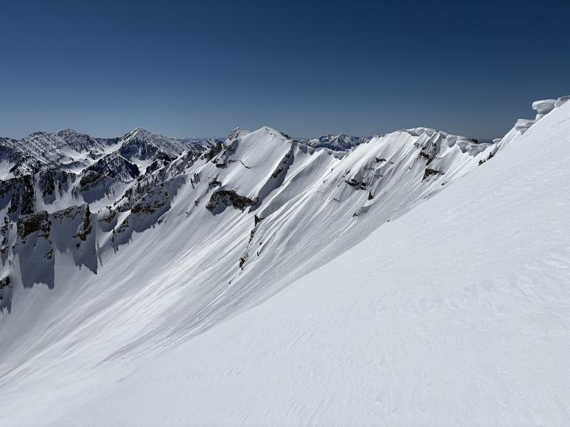
These drifts will be on the downwind side of ridges and gully features and you will want to stay back from sensitive new cornices on ridgelines.
Photo (Zimmerman-Wall) of cornices on an east facing slope on Cascade Peak.
Avalanche Problem #2
New Snow
Type
Location
Likelihood
Size
Description
The new snow has bonded well to the old snow surface; however, you may see shallow dry loose avalanches running on density changes with the newest snow. These may be 3"-5" deep and isolated to steeper terrain features.
It is now April and any hint of sun will turn the new snow into a mushy mess. Particular concern should be given to roofs in mountain neighborhoods, and lower elevation and southerly facing slopes which will be most impacted by any sun, even for a moment.
General Announcements
This information does not apply to developed ski areas or highways where avalanche control is normally done. This forecast is from the U.S.D.A. Forest Service, which is solely responsible for its content. This forecast describes general avalanche conditions and local variations always occur.