Join us at our 2nd Annual Blizzard Ball

Forecast for the Provo Area Mountains

Trent Meisenheimer
Issued by Trent Meisenheimer on
Thursday morning, March 4, 2021
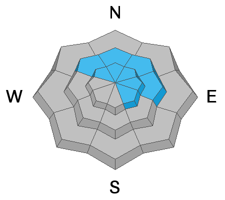
Today the avalanche danger is MODERATE for triggering a hard slab avalanche on a deeply buried persistent weak layer. You will find this problem on slopes that face northwest to southeast at the upper elevations and on slopes that face northwest to east at the mid-elevations. Human triggered avalanches remain possible.
Elsewhere we have a LOW avalanche danger, and normal caution is advised.
Low
Moderate
Considerable
High
Extreme
Learn how to read the forecast here
Weather and Snow
As a closed low spins over Las Vegas, northern Utah might see some residual wrap-around moisture this morning that could bring a trace to a few inches of new snow. This storm will be short-lived for us as it quickly clears out this afternoon. This morning the winds will blow from the southeast, and as the storm moves off into Colorado, the winds will later switch to the northwest. As the storm exits the stadium, we quickly dry out, heading into the weekend with the return of spring and plenty of sunshine Friday into Saturday. The good news: It seems there is a change in the pattern setting up for early next week as the storm track becomes more progressive and a series of troughs take shape.
This morning the current mountain temperatures are in the 25-33 °F range above about 8,000'. Southerly winds are spinning anemometers 5-10 mph with gusts into the 20's upper elevation ridgelines. The snow surface has taken a beating over the past few days, with much of the terrain now sunbaked, and this morning will be crusted. Dry, soft, settled powder snow can still be found at the mid and upper elevation north-facing terrain.
Recent Avalanches
Under yesterday's strong sunshine and warm temperatures, the new snow became wet, and there were wet avalanches of loose snow on slopes receiving direct sunshine. Several slides were spotted in Primrose Cirque on Mt. Timpanogos, and on Monday, one person observed five different slides in about a half-hour just above Aspen Grove. Otherwise, no new avalanche activity was reported yesterday from the Provo area.
Ad
Avalanche Problem #1
Persistent Weak Layer
Type
Location
Likelihood
Size
Description
Unfortunately, avalanches can still break near the ground on a persistent weak layer of old faceted snow that caused many avalanches about two weeks ago. The odds of triggering one of these slides have gone down significantly, but the consequences remain severe. I would continue to be very cautious in steep avalanche-prone terrain in the Provo mountains.
General Announcements
Please visit this website with information about Responsible Winter Recreation by the Utah Office of Outdoor Recreation.

This information does not apply to developed ski areas or highways where avalanche control is normally done. This forecast is from the U.S.D.A. Forest Service, which is solely responsible for its content. This forecast describes general avalanche conditions and local variations always occur.