Join us at our 2nd Annual Blizzard Ball

Forecast for the Provo Area Mountains

Mark Staples
Issued by Mark Staples on
Wednesday morning, March 31, 2021
The avalanche danger is LOW. By this afternoon there should be some small, wet loose avalanches that occur as the snow warms and surface layers become wet.
On slopes that remain frozen, the greatest threat is falling on the hard snow and being unable to stop.

Continue to maintain safe travel habits; this means exposing one person at a time to avalanche terrain, having someone watch them from a safe location, and not traveling above or below other parties.
Low
Moderate
Considerable
High
Extreme
Learn how to read the forecast here
Special Announcements
Thank you to everyone who helped make our Spring Campaign a huge success. We are grateful for your support and look forward to continuing to serve you with forecasting, education, and awareness programs in new and exciting ways.
Weather and Snow
Yesterday's high temperatures were ranged from the mid 20s F to low 30s F.
This morning temperatures are mostly in the upper teens F. Westerly winds at ridgelines are blowing 5 mph gusting to 10 mph.
Today high temperatures should climb into the upper 30s F to low 40s F. Winds will be generally light.
The snow this morning is frozen solid, firm, and icy on most slopes. It should soften today with warmer temperatures and light winds.
Recent Avalanches
Yesterday there were no avalanches reported, and the snow remained mostly frozen.

As always, find all recent observations and avalanches HERE.
Ad
Avalanche Problem #1
Wet Snow
Type
Location
Likelihood
Size
Description
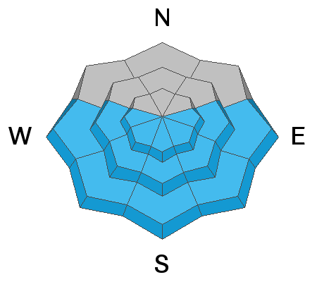
Today the snow should warm some and become wet enough to improve the riding a little. It may become wet enough in some places to produce small wet loose avalanches. Areas near rocks and cliffs should heat up the most and will be likely places for wet avalanches.
Looking ahead, the next 4-5 days will have warmer temperatures each day. There should be more wet avalanches happening in coming days as heat is pushed deeper into the snowpack. However, clear skies each night will help the snowpack refreeze. How warm the snow becomes each day and how much it refreezes overnight will determine the scale of wet snow avalanche activity.
In terms of riding conditions, they should improve as the snow goes through the melt-freeze cycle each day to produce large ice grains commonly called corn snow. The key to finding good riding in corn snow and avoiding avalanches is to be riding just as the top inch or two of snow begins to warm and melt. Often you can start on east facing slopes that warm first and move around the compass as the sun warms other slopes. Then head home as the snow gets wetter and slushier.
General Announcements
Please visit this website with information about Responsible Winter Recreation by the Utah Office of Outdoor Recreation.

This information does not apply to developed ski areas or highways where avalanche control is normally done. This forecast is from the U.S.D.A. Forest Service, which is solely responsible for its content. This forecast describes general avalanche conditions and local variations always occur.