Forecast for the Provo Area Mountains

Drew Hardesty
Issued by Drew Hardesty on
Saturday morning, March 28, 2020
This morning we have a MODERATE dange at the upper elevations where human triggered avalanches involving new wind drifts and lingering soft slab avalanches 1-2' deep remain possible. The best and safest riding remains on sun and wind-sheltered slopes less than 35° in steepness.
As always, the springtime sun can immediately affect riding and avalanche conditions. If the cold snow becomes damp with sun and daytime heating this afternoon, wet sluffs will be likely. Choose terrain accordingly.
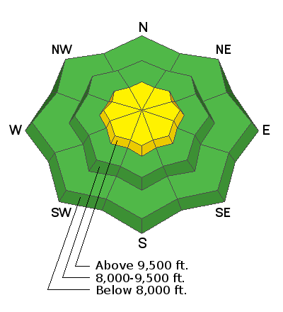
Low
Moderate
Considerable
High
Extreme
Learn how to read the forecast here
Special Announcements
If you rely on the UAC forecasts each day you get out, consider making a donation during our Spring Awareness Campaign to help us continue providing the avalanche forecasts and education you rely on.
The UAC encourages everyone to follow direction from federal, state, city and county officicals. The following is from Joe Dougherty, spokesman for the Utah Division of Emergency Management:
Though outdoor recreation is still permitted under the governor’s Stay Safe/Stay Home directive, we recommend that people maintain a distance of at least 6 feet.
Be extra cautious to avoid injuries outdoors. We are working with our hospital systems to conserve as much personal protective equipment as possible in case of hospitalizations.
Most outdoor injuries can be prevented. Know the conditions and know your limits so you don’t end up in a hospital.
Weather and Snow
Skies are mostly cloudy with temps in the upper 20s to low 30s. Winds are 10-15mph with gusts to 20. Along the highest elevations, however, hourly wind speeds have been averaging 30-35mph with gusts to 50. Looks like perhaps a trace to an inch overnight. Skies will turn partly cloudy by the afternoon and the winds should lose steam as they back to the west.
Riding conditions have been quite good and will remain so in the wind and sun sheltered terrain. Many slopes were crusted yesterday by the sun.
Recent Avalanches
We did hear about one avalanche near the Ant Knolls yesterday, see video below.

Otherwise, it was quite active in the central and northern Wasatch; I imagine similar issues in the Provo mountains.
Ad
Avalanche Problem #1
New Snow
Type
Location
Likelihood
Size
Description
In the older "new snow", myriad slow-to-heal weaknesses remain in snowpack over the past week: low density stellars, graupel, and particularly weak snow above the old sun and melt-freeze crusts. Each slope must be assessed separately as there is a great deal of spatial variability in the overall snow stability. Most terrain out of wind can be ridden safely, but not all. Low angle slopes will ride quite well today without all the headaches and uncertainty.
Avalanche Problem #2
Wind Drifted Snow
Type
Location
Likelihood
Size
Description
New winds drifts will be sensitive in the higher elevations today and particularly on north to east to south facing aspects. These, I suspect, may be surprisingly sensitive and up to 12-18" deep along the higher elevations. Be warned that they may also be crossloaded beyond subridges and - when triggered - may stress the old interface another 1-2' down. Shooting cracks are classic signs of instability. These will be primarily along the upper elevations.
Additional Information
Skiing and riding at closed ski resorts - Some resorts allow access now, and some do not. Please check HERE for the latest info on ski area access.
New to the backcountry (including riding at closed resorts) - Watch the award-winning, 15 minute Know Before You Go video, or take the 5-part, free online-learning series.
General Announcements
This information does not apply to developed ski areas or highways where avalanche control is normally done. This forecast is from the U.S.D.A. Forest Service, which is solely responsible for its content. This forecast describes general avalanche conditions and local variations always occur.