Join us at our 2nd Annual Blizzard Ball

Forecast for the Provo Area Mountains

Greg Gagne
Issued by Greg Gagne on
Friday morning, February 5, 2021
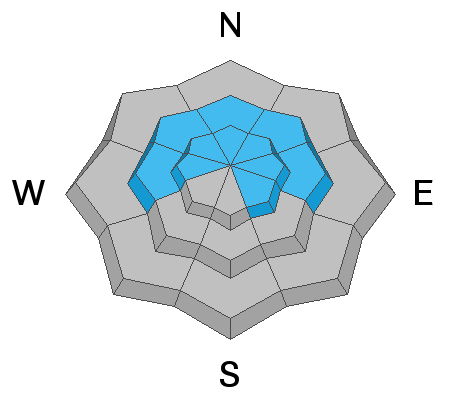
The avalanche danger is CONSIDERABLE on all aspects at the upper elevations and at mid-elevations facing west through north and southeast. Mid-elevation south and southwest aspects and low elevations have a MODERATE avalanche danger. Avalanches may break down up to 5' deep and over several-hundred feet wide.
Be prepared for rapidly-changing avalanche conditions today. Strong winds and snowfall will create a rising avalanche danger and it is possible the danger will rise to HIGH this afternoon, especially during any period of heavy precipitation intensity.
Low
Moderate
Considerable
High
Extreme
Learn how to read the forecast here
Special Announcements
With great sadness, the Utah Avalanche Center reports that a 57-year old skier, Kurt Damschroder of Park City, was killed Saturday, January 30 in a backcountry avalanche off of Square Top Peak, located on the Park City Ridgeline. The final accident report can be found HERE. Our thoughts go out to those affected by this tragic accident, especially the family and friends of Kurt.
Since February 1, there have been nine other avalanche fatalities in the US.
Weather and Snow
The Provo mountains did not fare as well as mountains to the north with only a few inches of snow from the Wednesday/Thursday storm. But a cold and windy storm is forecasted for today with periods of heavy snowfall and strong winds. As of 6 am, temperatures range through the low to mid-teens F. with strong winds from the west/northwest. At mid- elevations winds are averaging in the 20's mph with gusts in the 30's mph. Along upper-elevation ridgelines winds are gusting in the 40's mph. At 11,000' winds are averaging in the 40's and 50's mph with gusts over 70 mph.
Snowfall will begin this morning and continue throughout the day with periods of heavy snow likely. By late afternoon 4-6" of snow are possible. The west/northwest winds will continue to be strong through much of the day, averaging in the 20's and 30's mph at the mid-elevations and 40's at the upper elevations. Very strong gusts of 40-50 mph can be expected at the mid and upper elevations with gusts in the 70's mph at 11,000'. Temperatures will be in the low 20's F.
Snowfall should continue overnight and into Saturday morning, with an additional 1-2" possible.
Recent Avalanches
Other than sluffing in the new low-density snow, no backcountry avalanches were reported on Thursday.
However, it has been a very active week with nearly 40 natural and human-triggered avalanches reported to the UAC from the Salt Lake mountains. The actual number is likely much higher. This included two very-close calls as well as the second avalanche fatality of the season in the state. Get caught up by reading our Week in Review for this past week where we highlight significant avalanche, snow, and weather events.
Ad
Avalanche Problem #1
Persistent Weak Layer
Type
Location
Likelihood
Size
Description
Various layers of weak, faceted snow and depth hoar are present on mid and upper elevation aspects facing west through north and southeast. Over this past week, several natural and human-triggered avalanches failed in these persistent weak layers, now buried 2-4' deeply. Today's rapid loading of new snow and wind-drifted snow may be enough to again overload these deeply-buried weaknesses, with avalanches breaking down up to 5' deep and over several hundred feet wide. You may not get any warnings - such as collapsing or cracking - of these instabilities until you hit the right spot on the slope and trigger a large, dangerous, and likely unsurvivable avalanche.
The best advice is to avoid being on or underneath slopes steeper than 30° on these aspects at the mid and upper elevations where this persistent weak layer is present.
The video below is from the remotely-triggered slide on Tuesday in Days Fork in the Salt Lake mountains that was 3' deep and failed in the buried persistent weak layer.
AVALANCHE TREND: INCREASING
Avalanche Problem #2
Wind Drifted Snow
Type
Location
Likelihood
Size
Description
Strong winds will drift snow at the mid and upper elevations. Although the winds are from the west/northwest, these strong winds can work around terrain features and drift snow on any aspect. These fresh drifts will be on top of low-density snow that fell overnight Wednesday and into Thursday and may be sensitive. As mentioned under the persistent weak layer problem, these drifts may also be enough of a load to trigger larger avalanches failing in the deeply-buried weak faceted snow.
Cornices may also quickly develop today and be quite sensitive. Stay well-back from corniced ridges.
AVALANCHE TREND: INCREASING
General Announcements
Please visit this website with information about Responsible Winter Recreation by the Utah Office of Outdoor Recreation.

This information does not apply to developed ski areas or highways where avalanche control is normally done. This forecast is from the U.S.D.A. Forest Service, which is solely responsible for its content. This forecast describes general avalanche conditions and local variations always occur.