Join us at our 2nd Annual Blizzard Ball

Forecast for the Provo Area Mountains

Trent Meisenheimer
Issued by Trent Meisenheimer on
Wednesday morning, February 3, 2021
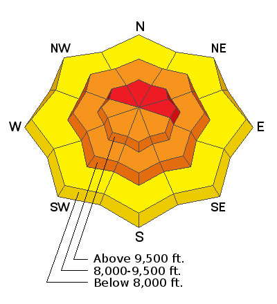
The avalanche danger is HIGH on upper elevation steep slopes facing northwest, north, northeast, and east, and traveling in avalanche terrain is NOT recommended. There is a CONSIDERABLE danger on upper elevation steep slopes facing southeast, south, southwest, west, and on all steep mid-elevation slopes. There is MODERATE avalanche danger on slopes below 8,000'.
In areas where the snowpack is weak and faceted: Human triggered avalanches 2-5'+ deep are likely and potentially unsurvivable. Don't be fooled by the lack of signs of instability today.
Low
Moderate
Considerable
High
Extreme
Learn how to read the forecast here
Special Announcements
With great sadness, the Utah Avalanche Center reports that a 57-year old skier, Kurt Damschroder of Park City, was killed Saturday in a backcountry avalanche off of Square Top Peak, located on the Park City Ridgeline. The final accident report can be found HERE. Our thoughts go out to those affected by this tragic accident, especially the family and friends of Kurt.
Weather and Snow
The National Weather Service has issued a Winter Weather Advisory in effect until 3:00 pm on Thursday. A Classic Utah cold front will slam into the Wasatch Mountains this morning, bringing colder air and mountain snow. Winds will veer from the southwest to the northwest as the front moves through the valley. The other good news; this storm will have a post-frontal orographic environment as the upper-level trough continues driving the northwest flow. I am excited - finally, a classic storm! All in all, we should see 4-8" of new snow by Thursday afternoon.
Yesterday morning the southerly winds picked up once again and have been blowing 15-25 mph with gusts into the 30's for almost 24hrs now. Currently, the wind continues to blow at speeds of 15-25 mph from the southwest, and some gusts are hitting 40 & 50 mph at the upper elevations. Even the mid-elevations' anemometers are spinning 15-20 mph with gusts into the 40's—No Bueno.
Mountain temperatures are in the mid 20's °F above about 8,000' while lower elevation trail-heads hover just above freezing this morning. The good news is this cold front should drop the mountain temperatures and winter returns.
Recent Avalanches
The string of recent natural and human triggered avalanche observations continue to pour into the UAC. In total, we've had 51 avalanches reported to the UAC in the past eight days. Please take a few minutes and scan through the observation cue; it's impressive.
Yesterday in the Provo Mountains in Big Springs, a group of skiers triggered a large avalanche with a slope cut as they considered riding the slope. The avalanche was 2.5' feet deep 150' wide.
Yesterday, in the Wasatch, we had a large natural avalanche reported from South Monitors that was 2' deep 300' wide and ran 700' vertical to the flats. This avalanche is likely a repeat offender as this bowl already avalanche this season. Another party remotely triggered (from a distance) an avalanche on Chicken Sh*t Ridge that broke 3-4' deep 500' feet wide. This one really concerns me because it was triggered from a distance, meaning steep slopes are still sensitive to human triggers.
Ad
Avalanche Problem #1
Persistent Weak Layer
Type
Location
Likelihood
Size
Description
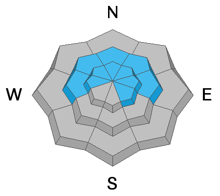
Steady winds from the past 24 hours and today's new snow (loading) will increase the likelihood of triggering a deep and dangerous slab avalanche today. This problem is most pronounced on steep slopes facing west to north to southeast at the mid and upper elevations. I am going with a HIGH avalanche danger based simply on the Travel Advice: Very dangerous avalanche conditions, and traveling in avalanche terrain is NOT recommended.
We are primarily dealing with not one but two weak layers that are causing avalanches: a layer of facets and perhaps surface hoar buried Jan 22nd....and the old rotten facets and depth hoar in the basement. Both of these layers roared to life over the weekend, and the avalanche cycle - both natural and human triggered - was nothing short of impressive.
Signs of instability (cracking/collapsing) might not be present today, and you might even see tracks on the slope. In no way does this mean it's safe. All someone has to do is hit the right spot; the slope collapses, shatters like pane of glass; you look left, you look right with nowhere to run. The avalanche you just triggered will likely be 2'-5' + deep and hundreds of feet wide, and likely unsurvivable. The best thing we can do is avoid the avalanche altogether by sticking to slopes under 30° degrees.
AVALANCHE TREND: INCREASING
Avalanche Problem #2
Wind Drifted Snow
Type
Location
Likelihood
Size
Description
New and developing wind drifts should be on your radar if headed into the more exposed terrain today. The past 24 hrs of southerly winds were strong enough to paint part of the landscape with soft wind drifts easily large enough to catch and carry a person in steep terrain. The wind drifts will be more pronounced on upper elevation west to north to east-facing slopes. On slopes that harbor weak faceted snow, the wind continues to overload those slopes making the avalanches larger and more connected.
AVALANCHE TREND: STEADY
Avalanche Problem #3
New Snow
Type
Location
Likelihood
Size
Description
As the cold front moves overhead, we can expect periods of high precipitation intensity (PI) (heavy snowfall). This will likely lead to dry loose avalanches that will either run naturally on their own in steep terrain/or with a little help from a human. Once the snow stacks up - watch out for soft storm slabs that can fail within the new snow. Shovel tilt test and small test slopes are a great way to see how the new snow is behaving.
General Announcements
Please visit this website with information about Responsible Winter Recreation by the Utah Office of Outdoor Recreation.

This information does not apply to developed ski areas or highways where avalanche control is normally done. This forecast is from the U.S.D.A. Forest Service, which is solely responsible for its content. This forecast describes general avalanche conditions and local variations always occur.