Join us at our 2nd Annual Blizzard Ball

Forecast for the Provo Area Mountains

Nikki Champion
Issued by Nikki Champion on
Monday morning, February 22, 2021
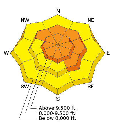
Areas of CONSIDERABLE avalanche danger exist on many slopes at the mid and upper elevations. Considerable means that dangerous human-triggered avalanches are likely. The danger is most prevalent on the west to north to southeast facing slopes where weak faceted snow exists and on any recently wind drifted terrain. Cornices are to be avoided.

Wet avalanches will be possible on the steeper sunlit slopes with clearing skies today.
Low
Moderate
Considerable
High
Extreme
Learn how to read the forecast here
Special Announcements
On Monday, February 22, at 7 PM, the UAC will livestream a one hour review and debrief of the tragic Wilson Glades avalanche accident, followed by a Q & A period. The link for registration is HERE.
A good primer for this will be to listen in to Friday's RadioWest conversation about avalanches and the incident. Stream it here or wherever you get your favorite podcasts.
Weather and Snow
This morning, skies are overcast and mountain temperatures range in the low 20s F. The west-northwesterly winds have begun dropping since yesterday, currently averaging 5-15 mph with gusts near 25 mph at the highest ridgelines.
Today, low clouds will sit over the mountains before clearing late morning. Temperatures will rise and skies will become mostly sunny with a few passing high clouds this afternoon. Temperatures will settle into the mid and high 30s F. The west-northwesterly winds will average 15-25 mph, with gusts up to 45 mph at the highest ridgelines.
Yesterday, the snow surface became damp in the afternoon at lower elevations and southerly aspects. Expect to find a firm crust this morning. The best riding conditions will be found in sun sheltered and low-angle terrain.

It finally feels like we have a real winter under our feet. Coverage is pushing 50-60" in the Provo area. Last week was a blur. Read more about it in Greg Gagne's patented Week in Review.
Recent Avalanches
Dangerous avalanche conditions consume the West: The backcountry community has suffered 23 avalanche fatalities in 23 days, the most recent from Idaho and Nevada. INFO. Utah is up to 6 avalanche fatalities for the season.

No new avalanches reported in the area yesterday, but a few new emerging avalanches from earlier in the week reported as visibility increased. Find all avalanches and observations HERE.
Ad
Avalanche Problem #1
Persistent Weak Layer
Type
Location
Likelihood
Size
Description
Drew said it well yesterday, “the difference between joy and terror is sometimes just a matter of a few degrees of separation – as in about 10 degrees of separation”. As we get farther from last week’s extreme danger ratings it will become increasingly tempting to step into steeper terrain, but with a persistent weak layer our options are simple:
Low-Risk – High Reward
High-Risk – High Reward
We must continue sticking to low-risk terrain. With the tricky snowpack structure that we currently have, we may not be presented with obvious signs of instability such as cracking or collapsing. As well, tracks on a slope offer zero indication of stability – it could be the third, fifth, or first skier on the slope that triggers this weak layer.
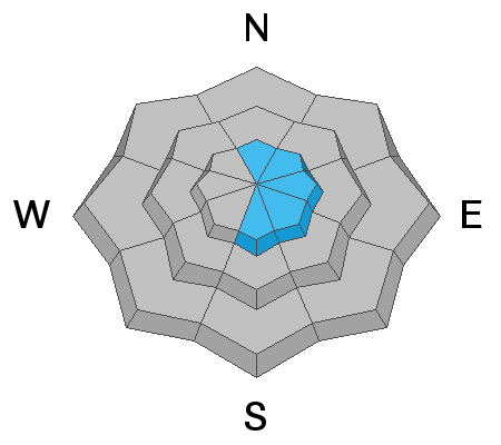
Patience is required, there is no outsmarting this problem. You are still likely to trigger a deadly avalanche 2-5’ deep in an area where the slab is thinner, such as rocky terrain, or in areas that have previously avalanched this winter. While it may be possible to find this layering anywhere in the Wasatch, I am most suspect of terrain along the periphery of the Cottonwoods such as Mill Creek, the PC ridgeline, Lambs/Mt Aire, Snake Creek, and the transitional zone toward the Bountiful/Sessions.
What to do:
  • Dig down and if you see weak facets in the snowpack, avoid steep terrain
  • Choose a completely safe uptrack. You are often more vulnerable while ascending.
  • Expose only one person at a time and keep tabs on people all the time
  • Know what's above and connected to you - these avalanches can be triggered from a distance or below.
  • Ski cuts and cornice drops can be dangerous and dangerously misleading indicators of stability
Avalanche Problem #2
Wind Drifted Snow
Type
Location
Likelihood
Size
Description
Lingering stubborn slabs of wind drifted snow can still be found in upper elevation terrain features today, particularly below ridgelines, subrides, and gullies. The elevated winds continue to increase the size of cornices on many ridgelines, making them more sensitive. Stay well back from - and avoid travel below - corniced ridges.
A triggered wind slab or cornice may or may not step down into deeper weak layers. Look for signs of recent wind loading such as smooth, rounded, pillow-shaped deposits of snow and avoid those slopes.
Avalanche Problem #3
Wet Snow
Type
Location
Likelihood
Size
Description
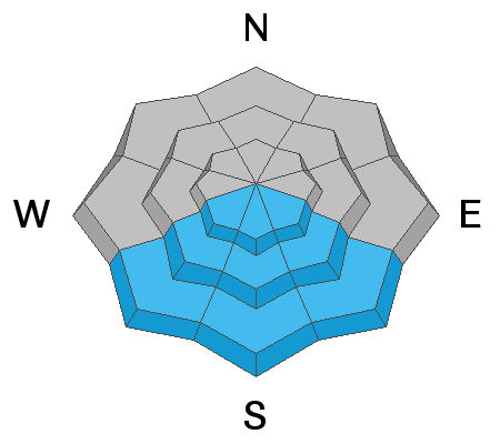
As the clouds clear this morning, the strong sun and warm temperatures will cause the snow to get wet. While wet snow avalanches can be exceptionally challenging to forecast- particularly with variable cloud cover. This wet snow may produce small, loose wet avalanches. A few could be bigger if they entrain more snow as they roll downhill.
Slopes with exposed cliffs and rock bands or gullies where the sunshine is concentrated will be the most likely places to see loose wet avalanches. The most dangerous locations will be in confined gullies this afternoon when these slides can happen on their own and hit you from above. Look for rollerballs and pinwheels rolling downhill and getting bigger as a sign that wet loose avalanches could start occurring.
Additional Information
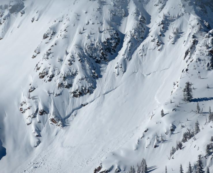
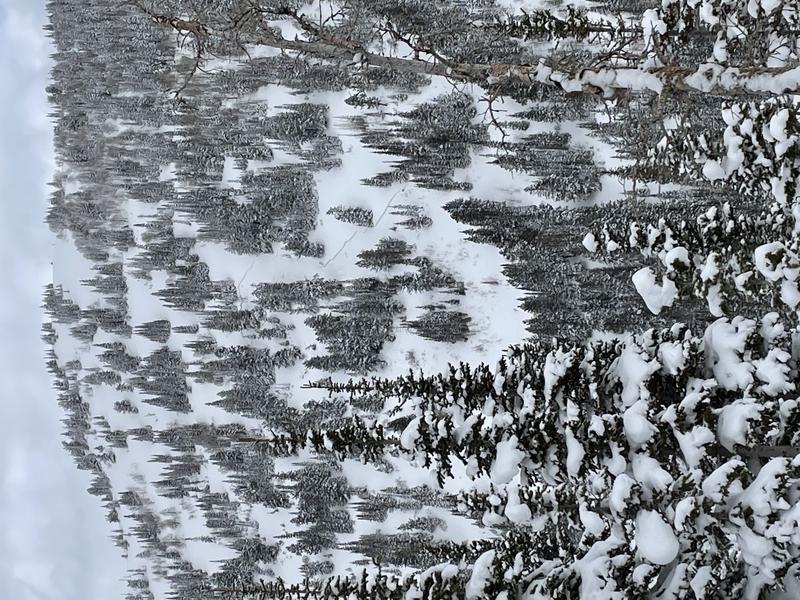
These are two examples of avalanches from the recent avalanche cycle: the first is off Tuscarora in the Brighton periphery. The second is near West Scotties in the lower White Pine drainage of LCC. The first is upper elevation, east facing and open terrain. The second is mid-elevation, west facing, and more interspersed with trees. Quite different from one another, but they are both avalanche terrain. Both could kill you. Slope angle is the great equalizer right now.
pc: Bill Nalli
pc: Mitch Potter
General Announcements
Please visit this website with information about Responsible Winter Recreation by the Utah Office of Outdoor Recreation.

This information does not apply to developed ski areas or highways where avalanche control is normally done. This forecast is from the U.S.D.A. Forest Service, which is solely responsible for its content. This forecast describes general avalanche conditions and local variations always occur.