Forecast for the Provo Area Mountains

Drew Hardesty
Issued by Drew Hardesty on
Tuesday morning, December 29, 2020
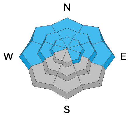
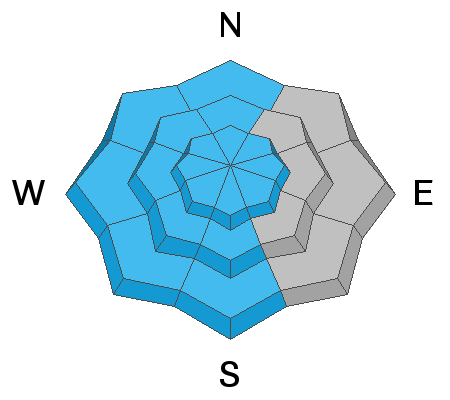
A CONSIDERABLE danger exists on many aspects in the mid and upper elevations. Human triggered avalanches 1-2' deep are likely on, adjacent to, or below steep slopes. A MODERATE danger exists for fresh drifts of wind blown snow even at the lower elevations.
Low
Moderate
Considerable
High
Extreme
Learn how to read the forecast here
Special Announcements
The Utah Avalanche Center podcast's second episode of season 4 is live - Managing Risk with Avalanches, Managing Risk with a Pandemic - A Conversation with state epidemiologist Dr. Angela Dunn
Stream here or tune in wherever you get your favorite podcasts

Deer Valley and Empire Canyon is closed to uphill travel as they begin operations in that terrain. Please avoid this area. Thanks.

Avy pro Pete Earle has a guest blog for us called Covid and the Avalanche Problem - The Strategic Mindset

Thanks to the generous support of our local resorts, Ski Utah, and Backcountry, discount lift tickets are now available.
Support the UAC while you ski at the resorts this season. Tickets are available here
Weather and Snow
Skies are clear.
Mountain temperatures are in the single digits up high, the teens elsewhere across the board. The Provo mountains were the big winner of this southerly track storm with 3" north of Provo Canyon and 7"(0.48") in the south fork.
Winds, mercifully, died down as the storm rolled off for the cities of the plain. The easterly winds yesterday blew 25-30mph, as recorded by both mid and upper elevation anemometers and you'll find evidence of that wreckage if you're headed into the backcountry today.
For today, we'll see mostly sunny skies, temps in the mid-teens up high, the mid-20s down low. Winds will be 15-20mph from the north.
The cold moon arrives this evening.
The Outlook - The next splitting storm arrives Wednesday night into Thursday and may offer an inch or two. Beyond that, perhaps another couple of storms just after the New Year.
Recent Avalanches
We had no reports from the Provo area mountains. In the central Wasatch, we had one more report of remotely triggered avalanche on a steep north facing slope at 9400'. On Sunday, avalanche snow safety teams at Park City Mountain Resort remotely triggered two avalanches (triggered at a distance) on steep northeast facing slopes at 8600'.
Ad
Avalanche Problem #1
Persistent Weak Layer
Type
Location
Likelihood
Size
Description
The snowpack currently is showing its cards with avalanches, cracking, and audible collapsing. In other words, when the snowpack is talking to you, it's best to listen. Beyond that, there's little mystery. Sure the snow is all white, but - if you look at Greg Gagne's snow pit from yesterday - it's really shades of white. The chalky white up top is our slab. The greyish crystalline white is our weak layer. Take a moment to dig down with your shovel today. If you see a similar structure, make sure to stick to low angle terrain.
Avalanche Problem #2
Wind Drifted Snow
Type
Location
Likelihood
Size
Description
You may be able to trigger one of yesterday's wind drifts in steep terrain today. REMEMBER that the winds were from the east (southeast>northeast), resulting in unusual drifting patterns. They'll be more prominent on north to west to south facing slopes at the mid and upper elevations. Drifts are also cross-loaded to the lee of sub-ridges and may be found well off the ridgelines. You can sometimes identify drifts by their rounded, chalky appearance.
REMEMBER that any slide triggered on west to north to easterly facing terrain may step down into older snow layers, resulting in a much more destructive avalanche.
Additional Information
General Announcements
Please visit this website with information about Responsible Winter Recreation by the Utah Office of Outdoor Recreation.

This information does not apply to developed ski areas or highways where avalanche control is normally done. This forecast is from the U.S.D.A. Forest Service, which is solely responsible for its content. This forecast describes general avalanche conditions and local variations always occur.