Join us at our 2nd Annual Blizzard Ball

Forecast for the Provo Area Mountains

Greg Gagne
Issued by Greg Gagne on
Friday morning, December 24, 2021
Heavy snowfall and strong winds have created dangerous avalanche conditions. The avalanche danger is HIGH on all upper elevation aspects and on mid-elevation aspects facing northwest through north and east. There is a CONSIDERABLE avalanche danger on mid elevation aspects facing west through south and southeast. Low elevations have a Moderate avalanche danger.
Both natural and human-triggered avalanches are likely. Travel in avalanche terrain is not recommended.
Low
Moderate
Considerable
High
Extreme
Learn how to read the forecast here
Avalanche Warning
THE AVALANCHE DANGER IS HIGH WITH DANGEROUS AVALANCHE CONDITIONS.
AN AVALANCHE WARNING HAS BEEN ISSUED FOR THE MOUNTAINS OF MUCH OF THE STATE OF UTAH, INCLUDING THE WASATCH RANGE...BEAR RIVER RANGE...UINTA MOUNTAINS...THE MANTI-SKYLINE...THE FISH LAKE REGION…PAHVANTS…TUSHARS…AND THE CEDAR CITY AREA MOUNTAINS.
HEAVY DENSE SNOWFALL AND STRONG WINDS HAVE CREATED DANGEROUS AVALANCHE CONDITIONS. BOTH HUMAN TRIGGERED AND NATURAL AVALANCHES ARE LIKELY. STAY OFF OF AND OUT FROM UNDER SLOPES STEEPER THAN 30 DEGREES.
Special Announcements
Avalanche conditions are very dangerous across most of the State of Utah as discussed by our staff in this video.
Weather and Snow
Overnight, 10-12" of heavy, dense snow containing over 2" of water fell in the Provo mountains. This is a significant loading event over a short period of time!
Temperatures range through the teens.
West/southwest winds were quite strong throughout Thursday and overnight, averaging in the 20's and 30's mph with gusts in the 50's mph at mid elevations. Along the upper-most ridges, wind speeds were averaging in the 40's and 50's mph with gusts in the 80's. Winds have subsided somewhat this morning, but are still moderate to strong out of the west/southwest.
For today, 4-8" of dense snowfall is forecasted, with the steadiest snowfall during the afternoon. Winds will be from the west/southwest and moderate to strong. At the mid elevations, winds will average in the teens with gusts in the 20's mph. Upper elevation ridges will average in the upper 30's with gusts in the 50's mph. Temperatures will rise into the upper 20's F.
Heavy snowfall and continued strong winds overnight and into Saturday morning.
Recent Avalanches
No avalanches were reported from the backcountry on Thursday. But we have seen numerous backcountry avalanches this past week with several near misses, including a solo rider who was caught and briefly carried in an avalanche in the Snake Creek drainage on Wednesday. Although centric to the Salt Lake mountains, you can get caught up by reading our Week in Review where we summarize significant snow and weather events from this past week.
Ad
Avalanche Problem #1
Persistent Weak Layer
Type
Location
Likelihood
Size
Description
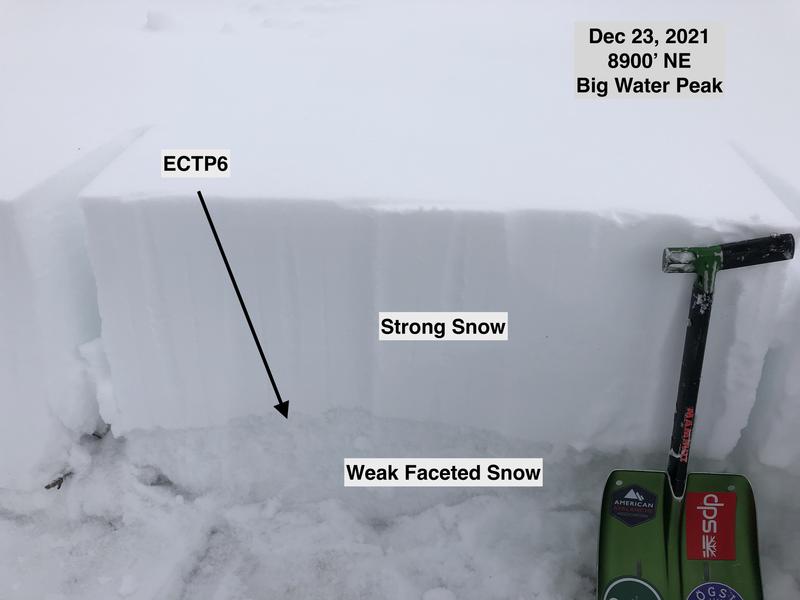
Heavy snowfall and strong winds have overloaded a persistent weak layer (PWL) of faceted snow down near the ground on mid and upper elevation aspects facing west through north and east. This weak layer formed from snow that fell earlier this Autumn, and once we buried this weak layer beginning on December 9, the PWL has become reactive with avalanching on every loading event of new snow and/or wind.
We have once again rapidly overloaded this weak layer with heavy snowfall and strong west/southwest winds, creating very dangerous avalanche conditions. On my field day yesterday in mid-elevations along the Big Cottonwood and Millcreek ridgelines, I was finding this weak layer to be very reactive to stability tests.
Avalanches failing on this weak layer may be triggered remotely (from a distance) or from below. Any avalanche failing on this PWL may break down 2-6' deep (possibly deeper) and propagate hundreds of feet wide.
Do not travel on or below slopes approaching 30 degrees or steeper on mid and upper elevation aspects facing northwest through east.
The photo below shows the poor structure of strong snow over weak snow.
Avalanche Problem #2
New Snow
Type
Location
Likelihood
Size
Description
Heavy, dense snowfall from overnight and into today may create sensitive soft slabs of new snow, especially at the mid and upper elevations. The new snow will be especially sensitive during any period of high precipitation intensity. Although you may find the new snow sensitive on all aspects, the new snow will create very dangerous avalanche conditions on slopes facing northwest through north and east where slides may break up to 6' deep into old snow down near the ground.
Avalanche Problem #3
Wind Drifted Snow
Type
Location
Likelihood
Size
Description
Strong winds from the west and southwest have created dense slabs of wind-drifted snow on all aspects at the mid and upper elevations. Strong winds can channel snow around terrain features and create fresh drifts on all aspects, including well-down off of ridge lines. On mid and upper elevation slopes facing northwest through north and east, these drifts will overload the buried layer of weak faceted snow down near the ground.
General Announcements
Who's up for some free avalanche training? Get a refresher, become better prepared for an upcoming avalanche class, or just boost your skills. Go to https://learn.kbyg.org/ and scroll down to Step 2 for a series of interactive online avalanche courses produced by the UAC.
This information does not apply to developed ski areas or highways where avalanche control is normally done. This forecast is from the U.S.D.A. Forest Service, which is solely responsible for its content. This forecast describes general avalanche conditions and local variations always occur.