Forecast for the Provo Area Mountains

Drew Hardesty
Issued by Drew Hardesty on
Sunday morning, December 22, 2019
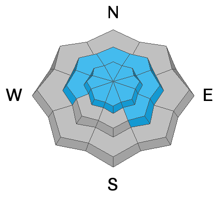
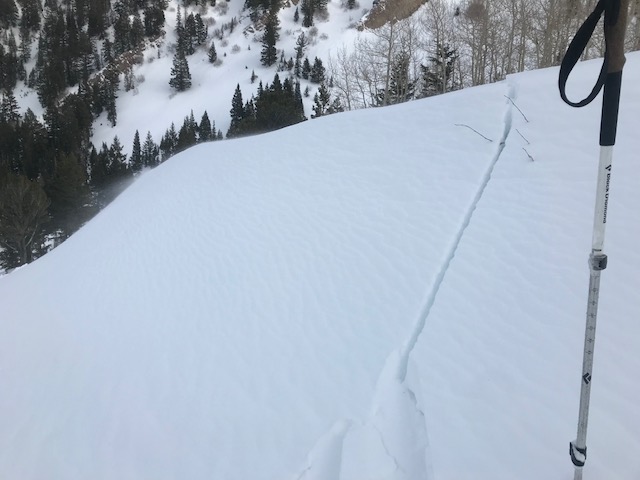
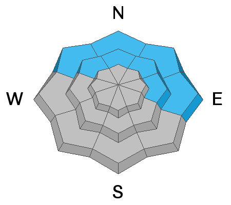
A scary MODERATE DANGER exists for triggering an avalanche 2-5' deep on steep northwest to east facing slopes of the mid and upper elevations. Avoid steep, thin, rocky terrain. A more widespread and tricky MODERATE danger exists for wind drifts on a variety of aspects and elevations. Lastly - and I can't believe I'm saying this - wet loose sluffs may also be triggered in warm, wind sheltered terrain and may pile up more deeply in terrain traps.
Strange weather causes strange avalanches.
Low
Moderate
Considerable
High
Extreme
Learn how to read the forecast here
Special Announcements
Final report for the Dutch Draw avalanche fatality is available HERE. Consider donating to the Matt Tauszik Memorial Fund to help his wife and young son.

Stocking Stuffers: Thanks to the generous support of our Utah ski resorts and Ski Utah, we have discount lift tickets available. All proceeds from these go towards paying for avalanche forecasting and education! Get your tickets here.
Weather and Snow
Skies are overcast with unseasonably warm temperatures and strong southwest winds. Mountain temperatures even into the mid-elevations are suffering through 36 hours of above-freezing temperatures and won't see relief until early tomorrow. The southwest winds are 20-25mph at the mid-elevations but blowing 40-50mph up high. Snow surface conditions have been damaged by the sun, wind, and warm temperatures. At least the inversion has weakened in the valleys.

Our Week in Review - summarizing the significant weather and avalanche events of the past week - can be found here.
Recent Avalanches
None.
Ad
Avalanche Problem #1
Persistent Weak Layer
Type
Location
Likelihood
Size
Description
Steep, rocky terrain should still be avoided in the mid to upper elevations on northwest to east facing slopes. The additional wind loading will add stress to the poor structure and it is possible that skiers, snowmobiles, and cornice-fall, etc, in the right spot may trigger a devastating avalanche. Trent and Dave Coyne demonstrated this in their avalanche class yesterday in the Central Wasatch (observation) - you'll see in their videos. Snow tests like these are great because they allow anyone to easily see the strong-over-weak snow structure while approximating an avalanche so we might extrapolate findings to larger slopes.
Danger Trend: Steady to Increasing
Avalanche Problem #2
Wind Drifted Snow
Type
Location
Likelihood
Size
Description
Thicker and more widespread. The southwest winds will continue to scour and erode any available snow and deposit it in the form of a checkerboard of soft and hard wind drifts in the mid and upper elevations, even in odd and unusual locations. At least two parties yesterday - including a party on Timpanogos - noted the wind drifting, experienced the cracking of wind slab...and altered their plans.
In some areas, these drifts may land on weak snow surfaces formed over the past week and may be surprisingly sensitive. These areas are more likely sun and wind sheltered terrain where the weak snow surfaces are not as susceptible to decay. I wouldn't be surprised to hear that some are triggered at a distance today or tomorrow.
Drifts are often smooth, scalloped, and rounded (see Tom Diegel's excellent photo below of texture and cracking) and are often formed to the lee of terrain features such as ridgelines, sub-ridges, and rocky outcroppings. Soft wind slabs you're "in the snow" with your sled or skis; hard wind slabs you're "on top of the snow". Hard slabs are often trickier because they allow you to get well on to them before the collapse where the wind pillow/teardrop lens shape tapers down.
Danger Trend: Increasing
Avalanche Problem #3
Wet Snow
Type
Location
Likelihood
Size
Description
I have to be honest. I am not sure what to make of these temperatures. Shady and sheltered snow surfaces have had a poor-at-best refreeze and may become wet and unstable. There'll be no secrets, though - you'll see if the snow surfaces are deteriorating (rollerballs, sluffing) and make decisions accordingly. Avoid being in and above terrain traps where the snow may pile up more deeply.
Additional Information
General Announcements
This information does not apply to developed ski areas or highways where avalanche control is normally done. This forecast is from the U.S.D.A. Forest Service, which is solely responsible for its content. This forecast describes general avalanche conditions and local variations always occur.