Join us at our 2nd Annual Blizzard Ball

Forecast for the Provo Area Mountains

Nikki Champion
Issued by Nikki Champion on
Saturday morning, December 19, 2020
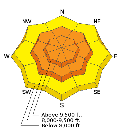
Today, with increasing winds and widespread weak faceted snow, the avalanche danger is CONSIDERABLE on all mid and upper elevation slopes. Travel in avalanche terrain is not recommended. Stay off of and out from underneath slopes 30° degrees and steeper at the mid and upper elevations. If you trigger an avalanche, it is likely to break down 18-24" and up to several hundred feet wide.

Low elevations are less likely to be loaded by the wind and have a MODERATE danger.
Low
Moderate
Considerable
High
Extreme
Learn how to read the forecast here
Special Avalanche Bulletin
AVALANCHE CONDITIONS REMAIN DANGEROUS FOR THE MOUNTAINS OF NORTHERN AND CENTRAL UTAH, INCLUDING THE WASATCH RANGE...THE WESTERN UINTAS, THE BEAR RIVER RANGE , AND THE MANTI-SKYLINE PLATEAU. RECENT HEAVY SNOWFALL AND DRIFTING FROM STRONG WINDS HAS CREATED AREAS OF UNSTABLE SNOW. HUMAN TRIGGERED AVALANCHES ARE LIKELY. TRAVEL IN AVALANCHE TERRAIN IS NOT RECOMMENDED. STAY OFF OF AND OUT FROM UNDERNEATH SLOPES STEEPER THAN 30 DEGREES
Special Announcements
Supreme area of Alta Ski Area is now closed to uphill/downhill travel. The summer road to Catherine's Pass will remain open.

Thanks to the generous support of our local resorts, Ski Utah, and Backcountry, discount lift tickets are now available. Support the UAC while you ski at the resorts this season. Tickets are available here.
Weather and Snow
This morning, there is an inversion in the mountains with a temperature in the mid to upper-teens F. Winds are southwesterly, at mid-elevations the winds are averaging around 10-15 mph, with gusts in the teens and low 20's mph. However, winds remain fairly strong at the upper elevations, averaging in the 20's mph with gusts in the 40s mph.
Yesterday, Ogden picked up another trace amount of snow bringing the snow totals since Thursday morning to 6-8". Water totals are near .50" in areas that received the most snow.
For today, expect partly sunny skies with little chance of precipitation. Temperatures will rise the to upper 20s and low 30s F. Winds will be elevated and west south westerly at mid-elevations, averaging in the teens to twenties across the board with gusts up to 35 mph. At upper-elevations winds will be west-northwesterly averaging 15-25 mph, with gusts up to 55 mph.

Week in Review: Our first Week in Review - where we summarize snow and avalanche conditions for the past week - has been published.
Recent Avalanches
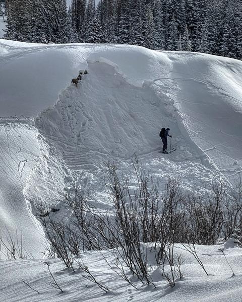
In the backcountry of Provo, there were no new avalanches reported. North of Provo, in the Cottonwoods there were nineteen human-triggered or natural avalanches reported Friday. Many of these avalanches were large, up to 400' wide, and triggered remotely (from a distance) failing in weak faceted snow that is now buried 18-30" deep. Overall this, in combination with the widespread cracking and collapsing being observed, is a huge indication of the sensitivity of our weak snowpack structure.
Photo: Mark White, Lower Cardiff Fork near the mine. Triggered remotely from 10 feet away. Even small slopes were sensitive to remote triggers yesterday.
Find a full list of yesterday’s avalanches here.
A video below from Observer Dave Conye showing widespread, likely natural activity throughout Grizzly Gulch Proper.
Ad
Avalanche Problem #1
Persistent Weak Layer
Type
Location
Likelihood
Size
Description
Yesterday, many human triggered and natural avalanches were observed. Most of these avalanches were triggered remotely, failing on the weak faceted snow and some were quite large, up to 2' deep and a few hundred feet wide.
Weak faceted snow from storms in early and mid-November is present on most aspects at the mid and upper elevations. The snowpack began to show signs of its fragility this past week with widespread cracking and collapsing and several human-triggered avalanches. Over the past two days, we quickly added around another foot of snow (or more), an inch of water, and continue to add strong winds at the mid and upper elevations. This quick increase in water and the elevated wind has overwhelmed the poor snowpack structure.

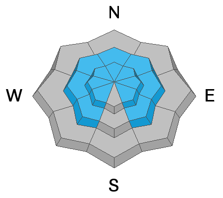
Today, you are very likely to trigger an avalanche in terrain steeper than 30° that has the persistent weak layer of faceted snow buried underneath the storm snow. These avalanches can be triggered remotely and from below.
Avalanche Problem #2
Wind Drifted Snow
Type
Location
Likelihood
Size
Description
Increased winds today will easily transport the new snow and form soft slabs of wind drifted snow on top of the weak faceted grains. This increase in winds will only further stress our poor snowpack structure. Triggering an avalanche that initially fails in the wind-drifted snow will likely break down more deeply into the weak faceted snow below.
Look for any signs of wind drifted snow on all upper-elevation aspects and avoid those slopes.
In areas that are sheltered from the elevated winds, you may be able to find sensitive storm slabs up to 1’ deep. Remember, terrain traps like gullies or creeks can cause these shallow slabs to pile up much deeper and could be enough to bury a person.
Additional Information
Writing an avalanche forecast is a team process. On Friday evening, Salt Lake forecasters Nikki Champion, and Greg Gagne discussed current conditions and thoughts for putting out Saturday's forecast. While sometimes things change between the evening and the following early morning, we like to share these with the public so you have a bit better of an idea of how we communicate and the shared thinking that goes into each forecast.
General Announcements
Please visit this website with information about Responsible Winter Recreation by the Utah Office of Outdoor Recreation.

This information does not apply to developed ski areas or highways where avalanche control is normally done. This forecast is from the U.S.D.A. Forest Service, which is solely responsible for its content. This forecast describes general avalanche conditions and local variations always occur.