Join us at our 2nd Annual Blizzard Ball

Forecast for the Provo Area Mountains

Nikki Champion
Issued by Nikki Champion on
Thursday morning, December 15, 2022
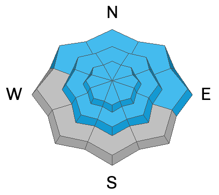
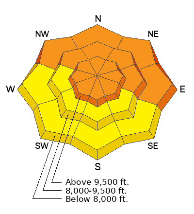
The avalanche danger is CONSIDERABLE on all upper-elevation aspects and mid and lower-elevation aspects facing northwest through east where natural and human-triggered avalanches may break 2-5' deep and 200' wide, failing on a persistent weak layer of faceted snow. The avalanche danger is MODERATE on west-south-southeast aspects.

Dangerous avalanche conditions exist! The north-facing slopes that are harboring old weak faceted snow surfaces are not to be messed with.

HEADS UP - The recent avalanche accidents we have been seeing on the northern end of the compass at the mid and lower-elevation bands is a huge red flag. These elevation bands are especially dangerous right now, and slopes can be triggered remotely, or from below. There is enough snow above summer hiking trails where people could easily get caught and buried in terrain traps. Give extra caution to the mid and lower elevation bands today.
Low
Moderate
Considerable
High
Extreme
Learn how to read the forecast here
Weather and Snow
This morning, skies are overcast and mountain temperatures are in the low teens F. Winds are west-northwesterly and averaging 5-10 mph at mid-elevations, at uppermost elevations winds are averaging 15-20 mph, with gusts near 30 mph.
Today, an additional trace to 2" of snow will fall and temperatures will climb into the mid-teens F. Winds at the ridgelines will blow from the northwest 10-20 mph gusting up to 35 mph.
A weak passing storm system should move out of the area by early afternoon. We can expect drier conditions after this storm and moving into the weekend. This unsettled weather has made for phenomenal riding conditions on lower-angle slopes.
With the addition of yesterday's snow and more snow overnight, the snowfall totals for the Provo area mountains since Sunday are 12-17" of snow and up to 1.5" of water.
Recent Avalanches
Yesterday, with some clearing weather recent avalanche activity was noted from the Provo area mountains. Most of these avalanches failed either within the new snow, or deeper in the persistent weak layer.
  • Dry Canyon bowl - west side of Timp near Everest Ridge - Upper elevation SE facing terrain - failed 1000' wide
  • Middle Finger - above Sundance into Dry Lakes - 9500' - ENE facing terrain
  • Slide Canyon - Provo Canyon - Aspect and Elevation unknown
  • Bunnell's Ridge - White Limbo to 1st bench - Upper elevation ENE facing terrain

In the Salt Lake Area Mountains we have had two avalanche accidents in two days.
  • Yesterday, there was an avalanche accident in Neff's Canyon. We have put together a preliminary report for this accident, you can find it HERE.
    • A solo skier was caught, carried, and partially buried in a drainage of the Thomas Fork of Neff's Canyon. A second solo person was traveling up the bottom of Neff's Canyon when he heard yelling and traveled up to the first skier. He found the first skier buried chest-deep in debris. The first skier had been buried for approximately 45 minutes when he was discovered. The second person then called 911 and began to extract the first skier. The first skier sustained serious injuries from the avalanche. The avalanche failed on a Northwest aspect at 7200'. The soft slab avalanche failed on a persistent weak layer 2' deep. The avalanche broke 200' wide. More details to follow after an accident investigation.
  • Tuesday, there was an avalanche accident in the Pink Pine zone. We have put together a preliminary report for this accident, you can find it HERE.
    • Two skiers were exiting the Red Pine Drainage in Little Cottonwood Canyon. While doing this they were below the summer hiking trail. The first skier triggered the avalanche just northeast of Pink Pine Ridge (See map in the report). As the second skier followed some distance behind the first, she saw there had been an avalanche. She started searching for the other skier with her transceiver, but then she saw him on the surface of the snow and called 911. The first skier sustained serious injuries. The avalanche failed on a North aspect at 7800'. The soft slab avalanche failed on the persistent weak layer 2.5-3' deep. The avalanche broke 60' wide and ran 300'. Drew, Greg, and Trent went to investigate this avalanche yesterday and did not feel comfortable descending the steep slope to access the crown. I think this speaks volumes about the conditions in the backcountry right now. Drew was able to do a crown profile on a similarly representative slope, you can find that information in the preliminary report.
Check out all the avalanches HERE.

If you see an avalanche please report it HERE.
Ad
Avalanche Problem #1
Persistent Weak Layer
Type
Location
Likelihood
Size
Description
A buried persistent weak layer of faceted snow (and some surface hoar) exists throughout the Provo area mountains buried 2-5 feet deep. It will most likely produce avalanches on northwest, north, northeast, and east facing slopes at all elevations. Even small slopes at low elevations can produce avalanches that may surprise you.
Out of the wind zone, at mid and low-elevation bands we have been seeing a lot of recent avalanche activity, including two avalanche accidents within the last two days. Both of these avalanches occurred under 8000'. This is a huge heads-up that these zones are equally, if not more, dangerous as the upper elevation bands. With all of the new snow, a sensitive soft slab avalanche could fail on top of the weak facets up to 3' deep. There is great skiing to be had on low-angle slopes and I will be staying away from steep northwest-north-east-facing slopes at all elevations.
Avalanches are slightly less likely on solar aspects because of the presence of ice crusts. There is a MODERATE avalanche danger on west-south-southeast aspects. Keep an eye out for higher-elevation south-facing areas that may have weak faceted snow under a stiffer slab of new or wind-drifted snow.
Avalanche Problem #2
Wind Drifted Snow
Type
Location
Likelihood
Size
Description
Since yesterday, the northwest winds have increased and have likely been transporting snow at the upper elevations. For the snowpack, when the winds drift snow, it's the same as if snow is falling out of the sky. The snowpack doesn't care where the snow comes from, it feels the added weight. So, on northerly-facing slopes, these winds have added snow and weight, and stress to the avalanche problem listed above. Any wind slab avalanche that you trigger has the potential to step down into deeper weak layers in the snowpack.
What to do? Look for evidence of fresh drifts and wind slabs that look wavy, rounded, smooth, and pillowy, and avoid those slopes.
Avalanche Problem #3
New Snow
Type
Location
Likelihood
Size
Description
The Provo area mountains have now received anywhere from 12-18" of new snow since Sunday. New snow avalanches will remain sensitive in steep terrain at all elevations on all aspects. All of this new snow may create both sensitive soft slab avalanches and long-running loose dry avalanches in steep terrain.
These new snow avalanches may step into the old-faceted snow-producing significantly larger avalanches.
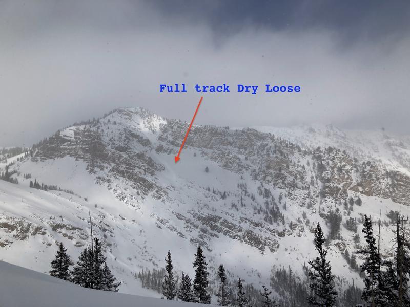
Photo of a full track dry loose avalanche from Upper American Fork/Sinner's Pass. (SZW)
Additional Information
Mark Staples has also written a season summary HERE.
Check out this forecast discussion.
General Announcements

This information does not apply to developed ski areas or highways where avalanche control is normally done. This forecast is from the U.S.D.A. Forest Service, which is solely responsible for its content. This forecast describes general avalanche conditions and local variations always occur.