Join us at our 2nd Annual Blizzard Ball

Forecast for the Provo Area Mountains

Drew Hardesty
Issued by Drew Hardesty on
Monday morning, December 14, 2020
Approach any steep wind drifted slope with caution.
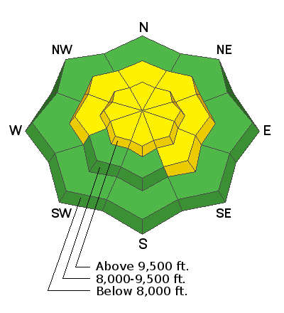
A MODERATE danger exists on some slopes at the mid and upper elevations. The danger will be more pronounced on steep northwest to north to east facing slopes. Human triggered avalanches a foot deep are possible and may be triggered at a distance. They may also be triggered from below. Collapsing and cracking are immediate signs of an unstable snowpack.
Please make conservative decisions to avoid getting hurt and further stressing emergency services and the health care system.
Low
Moderate
Considerable
High
Extreme
Learn how to read the forecast here
Weather and Snow
It's lightly snowing in the mountains and as of 4am, most areas have picked up a trace to 2". Temperatures are in the mid to upper teens.
It is the winds, however, that played the spoiler. The southwest winds picked up in the early evening with hourly averages of 20-30mph with gusts to 50mph. They're currently blowing 15-20mph as they continue to shift to the west and northwest.
For today, we'll see off and on snowfall that may add up to an additional 1-2" of low density snow.
Winds will be 10-15mph from the northwest; temperatures will be in the mid-teens up high, the low 20s down low.
Snow depths are roughly 12-18" in the Provo mountains with many south to southwest facing slopes brown prior to Friday's snowfall.

We'll see partly cloudy skies tomorrow with a plume of moisture associated with a warm front Tuesday night into Wednesday. This should be primarily along the Idaho border however. The next storm system looks to arrive Thursday night.
Recent Avalanches
We did not hear of any avalanche activity in the Provo area mountains, however in the central Wasatch, a skier was briefly caught and carried in a 12" deep and 35' wide avalanche that broke well above him on Sunset Peak (pic below). This avalanche is in steep north facing terrain at 10,500' in backcountry terrain between Alta and Brighton.
Ad
Avalanche Problem #1
Persistent Weak Layer
Type
Location
Likelihood
Size
Description
I suspect that - owing to the increased southwest winds - that some shallow avalanches ran naturally last night. Today, those same types of avalanches may be triggered by a skier or rider on or on approach to a steep wind drifted slope. Most slopes yesterday did not have a cohesive slab but today many do. I believe that the fresh wind drifts are now just the slabs that our previous weak layers have been waiting for. Collapsing and cracking are sure-giveaways to warn you away from steep terrain. Remember that these avalanches may be triggered from a distance or from below.
Problem: Nearly all aspects and elevations held very weak faceted sugar snow before the storm. The dangerous slopes will be the ones where winds have drifted snow into a cohesive slab. Unfortunately, many of the tell-tale signs of drifts (rounded, chalky, etc) will be covered and hidden by the new low density snow.
Solution: Slope angle is the key. Stay off of and out from underneath slopes 35° and steeper. See UAC forecaster Toby Weed's video below.
Avalanche Problem #2
New Snow
Type
Location
Likelihood
Size
Description
Sluffing in the steepest terrain is possible today with the additional snowfall. These will occur independent of aspect and may be enough to either gouge down into the older weak faceted snow or potentially trigger a fresh wind drift.
Additional Information
General Announcements
Please visit this website with information about Responsible Winter Recreation by the Utah Office of Outdoor Recreation.

This information does not apply to developed ski areas or highways where avalanche control is normally done. This forecast is from the U.S.D.A. Forest Service, which is solely responsible for its content. This forecast describes general avalanche conditions and local variations always occur.