Forecast for the Provo Area Mountains

Nikki Champion
Issued by Nikki Champion on
Thursday morning, January 9, 2020
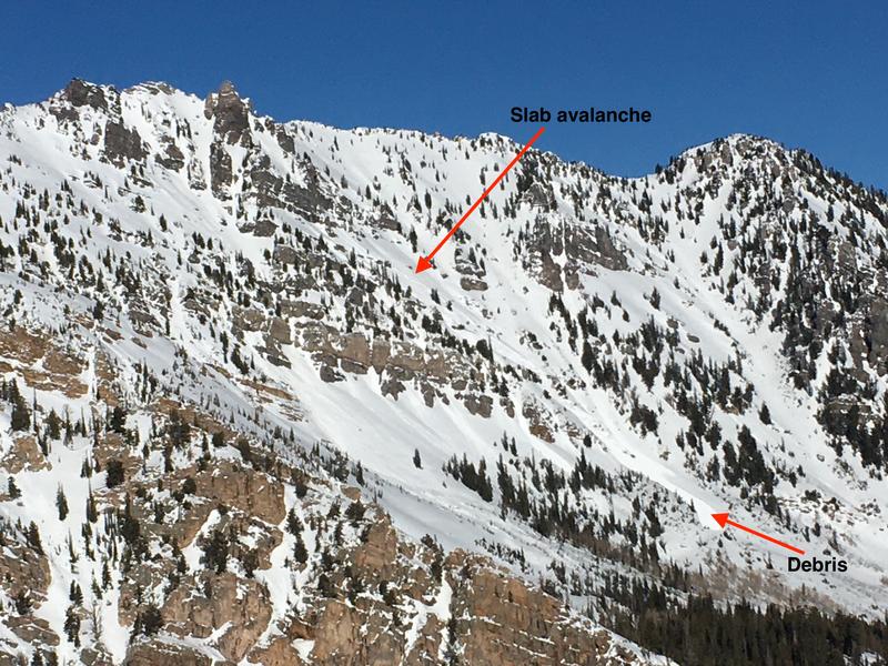
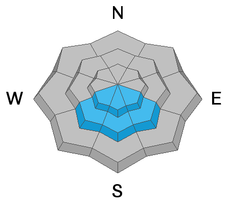
A MODERATE danger exists on all upper and mid-elevation aspects where fresh slabs of wind drifted snow can be found and human triggered avalanches are possible. A MODERATE danger also exists on southwest through southeast-facing mid-elevations where triggering a slab on the persistent weak layer is possible.

A LOW danger exists on all low elevation aspects where generally safe avalanche conditions exist.
Low
Moderate
Considerable
High
Extreme
Learn how to read the forecast here
Special Announcements
Get discount lift tickets HERE. Thanks for this generous support from Utah Ski Resorts and Ski Utah. All proceeds go directly to supporting the UAC.
New to the backcountry or in need of a refresher? Consider taking a companion rescue course offered at Woodward Park City, January 14, 5:30-9 p.m.
Weather and Snow
Since yesterday morning, the Provo area mountains picked up 1-3 inches (0.05-0.15 inches of water) of low-density snow in mountains. The bulk of this snow came in yesterday midday.
This morning, mountain temperatures are in upper teens F at trailheads and low teens to single digits F at ridgetops. Westerly winds have backed off this morning after blowing all day yesterday and into the early evening with gusts near 50 mph at the upper elevations early last night.
Today, the westerly winds will remain light overall but we could see some gusts near 30 mph before the wind switches to west-northwesterly and start to pick up again this evening. Occasional snow showers will continue through the day with no real accumulation. Temperatures will be in the low 20s F.
Recent Avalanches
Yesterday, no avalanches were reported in the Ogden area mountains. In the Wasatch backcountry the new snow was sluffing easily and running fast and far on a variety of old crusts. In the ski resorts, some natural dry loose and soft slab avalanches occurred, this includes a few small natural cycles directly following the period of most intense snowfall rates.
The most recent avalanches to occur in the old snow avalanche near Provo happened Tuesday. A slab avalanche was noted in the Pittsburg lake area on a steep southeast aspect. See full observation HERE.
Photo of Slab Avalanche in Pittsburg lake zone of upper AF - south facing at 10,400'. (Photo: S. Zimmerman-Wall)
A full list of recent avalanches and observations can be found in the Menu bar above.
Ad
Avalanche Problem #1
Wind Drifted Snow
Type
Location
Likelihood
Size
Description
Since yesterday morning, another 1-3 inches of snow fell, and winds have been relentless with to gust up to 50 mph at the highest of peaks into the evening. It’s simple, with snow available for transport and consistent winds, fresh slabs of wind drifted snow will be easier to trigger today.
While the wind was westerly, I would be looking for fresh wind drifts on all aspects at mid and upper elevations today. Look for slopes with signs of wind drifted snow and avoid them.
Photo of wind loading occurring on the Twins (Photo: S. Zimmerman-Wall)
In areas that don’t have wind drifted snow, and aspects that don’t possess the persistent weak layer simply watch for the new snow avalanches if you find higher snow totals. While I am unsure if this new snow will fracture as a slab I would expect the new snow to produce loose sluffs on steep terrain. Even a small loose sluff could knock you off your feet and drag you through unforgiving terrain, over a cliff, or into a terrain trap. Look for signs of instability throughout the day, and consider the consequences of steep terrain.
Avalanche Problem #2
Persistent Weak Layer
Type
Location
Likelihood
Size
Description
An unstable snowpack structure exists in uncommon places. A persistent weak layer of facets next to an ice crust is buried 2 feet deep on the southeast through southwest-facing terrain. We don't often have this problem on these aspects.
Yesterday we didn’t see any activity on this layer, but that could change today. With more loading from snow and wind, slab avalanches involving wind drifted snow and new snow avalanches could step down and fracture on this persistent weak layer. If you do choose to ride in south-facing terrain, the best risk management strategy will be to ride slopes less than 30 degrees in steepness.
Photo of Trent looking at the layer buried 14" down and in between 2 crusts. This photo is from a full day investigating this layer in American Fork. See full observation HERE.
The good news is that north-facing terrain doesn't have this layer and is riding well because it doesn't have a crust under the recent snow.
General Announcements
This information does not apply to developed ski areas or highways where avalanche control is normally done. This forecast is from the U.S.D.A. Forest Service, which is solely responsible for its content. This forecast describes general avalanche conditions and local variations always occur.