Forecast for the Provo Area Mountains

Drew Hardesty
Issued by Drew Hardesty on
Monday morning, January 27, 2020
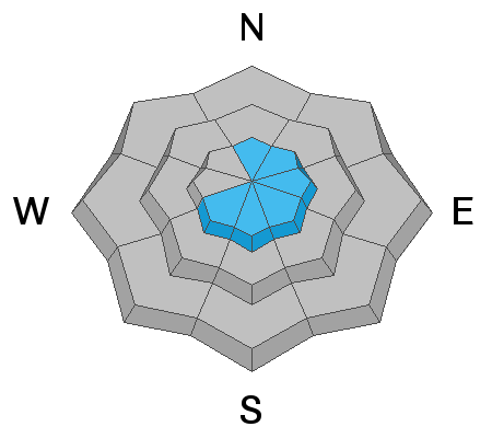
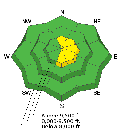
Most terrain has LOW danger. Areas of MODERATE exist primarily in the upper elevation wind drifted terrain. Human triggered avalanches are possible. Shooting cracks are clear evidence of unstable snow. Approach upper elevation wind drifted terrain with caution.
Low
Moderate
Considerable
High
Extreme
Learn how to read the forecast here
Special Announcements
NEW UAC Podcast: The Art of Storytelling Through Film - A Conversation with Trent Meisenheimer check it out HERE.
NEW UAC BLOG: The Anthropology of Risk - How Did We Get Here? Find it HERE.
Weather and Snow
Skies are overcast with snow totals of 3-4" in the Provo mountains. Winds are moderate from the northwest with temps in the mid-20s. Riding conditions will be vastly improved from the recent warm temperatures.
Recent Avalanches
No new avalanches were reported from the Provo area.
Ad
Avalanche Problem #1
Wind Drifted Snow
Type
Location
Likelihood
Size
Description
Wind drifts up to a foot may be found in the higher elevations of the Provo mountains and may be sensitive to the weight of a human. They'll be more prominent on terrain with an easterly component and may present as smooth, rippled and pillowy. Shooting cracks will be evident in wind drifted terrain. Winds are forecast to remain strong enough from the northwest to continue drifting snow over the course of the day (15-20mph).
Cornices are looming large over many ridgelines. These should be approached with great care.
General Announcements
This information does not apply to developed ski areas or highways where avalanche control is normally done. This forecast is from the U.S.D.A. Forest Service, which is solely responsible for its content. This forecast describes general avalanche conditions and local variations always occur.