Join us at our 2nd Annual Blizzard Ball

Forecast for the Ogden Area Mountains

Greg Gagne
Issued by Greg Gagne on
Friday morning, December 27, 2024
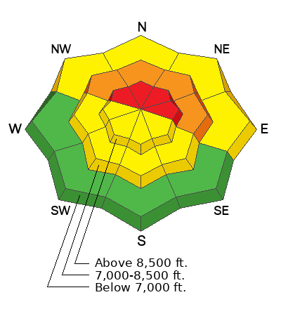
The Utah Avalanche Center has issued an Avalanche Warning for the Northern Wasatch mountains. The avalanche danger will rise to HIGH this morning as heavy snow and strong winds will overload a weak snowpack on slopes facing northwest through east where avalanches may break down 2-3 feet and over a hundred feet wide. Both human-triggered and natural avalanches are likely.
There is a CONSIDERABLE avalanche danger on mid-elevation northerly-facing slopes.
There is a MODERATE danger on low-elevation northerly-facing slopes and mid and upper-elevation southerly-facing slopes.

The avalanche danger is expected to remain HIGH into next week.
Low
Moderate
Considerable
High
Extreme
Learn how to read the forecast here
Avalanche Warning
What: Heavy snowfall and drifting by strong winds will elevate the backcountry avalanche danger over the next several days. Very dangerous conditions and HIGH avalanche danger are expected to develop in many areas.
When: Very dangerous conditions are expected in many backcountry areas through the weekend.
Where: For the mountains of Northern Utah and Southeastern Idaho, including The Wasatch Range and the Bear River Range.
Impacts: Very dangerous avalanche conditions are expected to develop on many slopes. Avalanches can be triggered on slopes steeper than 30 degrees. They may also be triggered remotely (from a distance) or from below.
What to do: Avoid traveling on or underneath steep terrain at mid and upper elevations in the backcountry. Carry and know how to use avalanche rescue equipment. Find safer riding conditions on slopes less than 30 degrees with no overhead hazard.
Weather and Snow
This Morning: Temperatures are in the 20's F. Winds are from the west and averaging in the teens, gusting in the 20's mph along exposed ridges, with the highest reaches of the Ogden Skyline gusting in the 30's mph. 24-hour snowfall totals are 7-12 inches containing 0.75 - 1.5 inches of water (snow water equivalent/SWE).
Today: The National Weather Service has issued a winter storm warning through 11 pm Saturday. Heavy snow and strong winds are forecast to arrive mid-morning. We are expecting 6-10 inches of snow during the day, with the highest amounts near Ben Lomond. Winds will be from the west and increasing through the day, gusting into the 20's and 30's mph, with stronger gusts along the highest elevations.
Extended: More snow and wind over the weekend and into Monday.
Recent Avalanches
No recent avalanches were reported from the Ogden area mountains. There was an avalanche accident on Tuesday in the Logan mountains, with a full burial, but fortunately a recovery where the rider incurred minor injuries. You can read the report here.

All recent observations are available here.
Ad
Avalanche Problem #1
Persistent Weak Layer
Type
Location
Likelihood
Size
Description
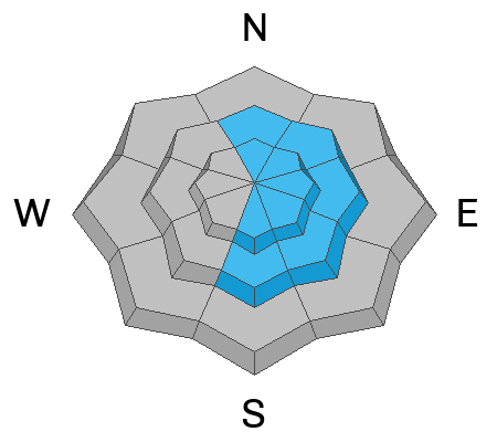
There is a weak layer of faceted snow at the mid and upper elevations on slopes facing west through north and east, including some upper-elevation southeast aspects. Strong winds and heavy snowfall forecast for today will overload this widespread persistent weak layer (PWL), creating dangerous avalanche conditions. Avoid being on, underneath, or adjacent to slopes steeper than 30 degrees. Avalanches involving PWLs can be triggered remotely (from a distance).
Video: Discussion about the snowpack.
Avalanche Problem #2
Wind Drifted Snow
Type
Location
Likelihood
Size
Description
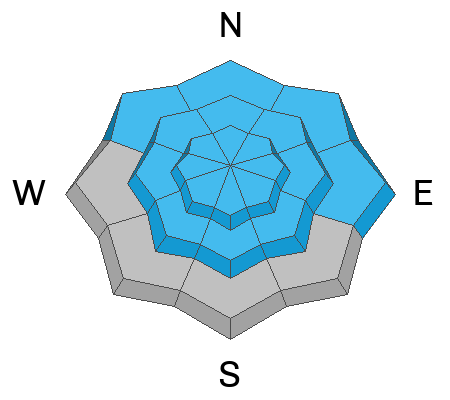
Strong winds will drift snow on many aspects at the mid and upper elevations. Watch for cracking and collapsing as they indicate sensitive wind-drifting. On slopes with a PWL, avalanches involving fresh wind drifts may break down into old faceted snow, creating much larger avalanches.
Avalanche Problem #3
New Snow
Type
Location
Likelihood
Size
Description
Watch for sensitive soft slabs of new snow, especially during any period of high precipitation intensity. Today's snowfall may have density inversions which can create especially sensitive soft slabs of new snow.
General Announcements
This information does not apply to developed ski areas or highways where avalanche control is normally done. This forecast is from the U.S.D.A. Forest Service, which is solely responsible for its content. This forecast describes general avalanche conditions and local variations always occur.