AVALANCHE WARNING!! Tap for info

Forecast for the Ogden Area Mountains

Paige Pagnucco
Issued by Paige Pagnucco on
Wednesday morning, December 18, 2024
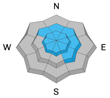
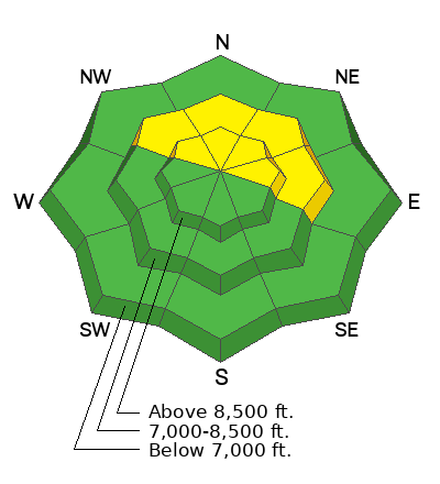
The avalanche danger is MODERATE on upper-elevation northwest to north to east-facing slopes, where it's possible to trigger avalanches failing on buried weak, faceted snow. Today's primary concern is wind slabs that fail on weak, faceted snow. As the day warms, we may also see wet, loose activity on sun-baked and/or warm slopes.
Low
Moderate
Considerable
High
Extreme
Learn how to read the forecast here
Weather and Snow
Mountain temperatures this morning are hovering in the mid to high 20s °F. Winds are blowing from the west-southwest in the teens MPH with gusts in the 20s MPH.

The Ogden zone was just a touch south of the firehose that hit northern Utah yesterday. Only a trace amount of snow was reported, not enough to lift spirits. Today, expect fairly benign weather with mostly sunny skies and mountain temperatures in the 30s °F. Some high clouds roll in this afternoon, and winds from the west-northwest should pick up a bit. We are locked into high pressure for the rest of the work week.

Yesterday's warm temperatures and low-elevation rain did little to improve the early-season shallow conditions. However, decent riding conditions might be found in sheltered, shaded, low-angle north-facing terrain that harbors soft snow.
*We may see wet, loose activity on sun-baked and warm slopes with warm temperatures today. Rollerballs were reported yesterday in the Cutler Ridge area.
Recent Avalanches
There was no reported avalanche activity yesterday. Two days ago, snow safety teams reported triggering (remotely and with explosives) persistent weak layer avalanches in mid and upper-elevation north-facing, wind-loaded terrain.
Read all observations here.
Ad
Avalanche Problem #1
Persistent Weak Layer
Type
Location
Likelihood
Size
Description
We are dealing with a classic strong snow over weak snow setup though the strong snow varies in strength and depth. In exposed areas, it is compacted and somewhat cohesive, and in sheltered areas, it is rather soft and "body-less."
Regardless, the faceted snow is our biggest concern mainly in upper-elevation terrain facing the north half of the compass.
Avalanche Problem #2
Wind Drifted Snow
Type
Location
Likelihood
Size
Description
The wind has been the big player recently, loading mid and upper-elevation slopes that had preexisting weak, faceted snow. Wind slabs can provide just enough support to allow you to venture further onto the slope before they fail, making them particularly dangerous and difficult to identify. Look for and avoid pockets of wind-drifted snow near ridgelines and terrain features like gullies and rock outcroppings.
General Announcements
This information does not apply to developed ski areas or highways where avalanche control is normally done. This forecast is from the U.S.D.A. Forest Service, which is solely responsible for its content. This forecast describes general avalanche conditions and local variations always occur.