Join us at our 2nd Annual Blizzard Ball

Forecast for the Moab Area Mountains

Eric Trenbeath
Issued by Eric Trenbeath on
Saturday morning, March 16, 2024
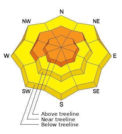
Recent snow accompanied by strong easterly winds have created a CONSIDERABLE avalanche danger on all aspects above treeline, and on steep slopes facing W-NW-N-NE near treeline. Human triggered avalanches involving both slabs of new and wind drifted snow are likely in these areas. As new snow accumulates today, the danger could be become more widespread and drop down in elevation. Be alert to changing conditions.
A MODERATE avalanche danger exists on all other steep slopes and human triggered avalanches involving both slabs of new and wind drifted snow are possible.
We have been observing an unevenly distributed weak layer of faceted snow on northerly aspects near treeline and below. Avalanches in the most recent snow maybe capable of breaking down to this weak layer. Give the new snow time to adjust before venturing into steep, northerly facing terrain.
Low
Moderate
Considerable
High
Extreme
Learn how to read the forecast here
Special Announcements
Road Conditions: The Geyser Pass Road is not plowed and driving conditions are sporty. There's a foot of snow at the parking lot and the road is drifted. 4x4 and good tires will be necessary. It's a good idea to carry chains. Consider parking at Trans La Sal today.
Grooming: I packed and rolled out the trail into Gold Basin yesterday.
***Support the UAC website rebuild by donating to our spring campaign. Save lives by making a donation today! HERE

The Banff Film Festival is returning to Moab on Thursday 3/21 and Friday 3/22 For tickets and information visit our event page.
Weather and Snow
6:00 a.m. Snow and Weather Data
24 Hour Snow 7" 72 Hour Snow 15" Season Total Snow 162" Depth at Gold Basin 65"
Winds on Pre-Laurel Peak: SE 5-15 G 20 Temp 27° F Percent of Normal: 106%

Weather
The nearly stationary closed low that remains parked over Arizona will continue to churn moisture into our area today. We should see snow showers off and on with another 6" possible by tonight. Winds from the SE will blow in the 10-15 mph range with 20 mph gusts along ridgetops. High temps at 10,000' will be in the upper 20's. Snow showers linger through tonight with some partial clearing on Sunday.
General Conditions
With well over a foot of snow stacking up since Thursday, turning and riding conditions are excellent, especially in sheltered areas. Strong, gusty winds from SE through NE yesterday, and the night before formed drifts up to 18" deep on all aspects, and in our travels yesterday we oberved that the most recent snow came in dense and inverted, and it was starting to form a slab. We did not find these drifts or slabs to be particularly sensitive, but we also didn't venture above treeline where the wind was really getting after it. I'd avoid steep, wind drifted slopes today and be on the lookout for a slabby conditions on all aspects and elevations. Blocks betweeen your skis indicate the presence of a slab, and cracking is a sign of instability.
Additionally, we have been tracking a weak layer of faceted snow in the upper pack. This layer is currently buried about a 18"-24" below the surface. We have been finding this very weak snow on some northerly facing slopes near treeline and below. The distribution of this layer is spotty at best, but it seems to be popping up in isolated areas of steep, sparsely treed terrain and it has produced a skier triggered avalanche. For more details on this weak layer see Dave's observations #1, #2. Dial back your terrain choices for now and let's see how the recent snow affects this layer.
Snowpack and Weather Data
Gold Basin Storm Stake (10,000')
Gold Basin SNOTEL site (10,000')
SNOTEL site near Geyser Pass Winter Trailhead (9600')
Wind Station on Pre-Laurel Peak (11,400')
NWS forecast for the La Sal Mountains.
Ad
Avalanche Problem #1
Wind Drifted Snow
Type
Location
Likelihood
Size
Description
Strong easterly winds yesterday and the night before formed slabs of drifted snow up to 18" deep on all aspects. They are more widespread on northerly aspects, but in our travels yesterady we also found them on south facing slopes where they were often interspersed with scoured surfaces. Drifts were stubborn to crack, and you may have to get down slope aways before they release above you. Fresh drifts are recognizable by their smooth, rounded appearance and cracking is a sign of instability. Avoid, steep, wind drifted slopes today, especially above treeline where human triggered avalanches are likely.
Avalanche Problem #2
New Snow
Type
Location
Likelihood
Size
Description
Human triggered soft slab avalanches involving the most recent snow are possible on all aspects and elevations today. We did not find conditions to be particularly sensitive yesterday, but the inverted, and overall cohesive nature of the most recent snow means that storm slab avalanches are possible. Utilize test slopes before committing to steeper terrain. Blocks between your skis indicate the presence of a storm slab, and cracking is a sign of instability.
Additional Information
Want some more insight into the La Sal Mountains as well as the communal impacts of a tragic avalanche? Check out the latest UAC podcast with forecaster Eric Trenbeath where he discusses the range, it's often treacherous snowpack, and how the devastating avalanche in February, 1992, affected the Moab community.
Our avalanche beacon checker sign and beacon training park are up and running. A huge thanks to Talking Mountain Yurts for sponsoring those this season!
Sign up for forecast region-specific text message alerts. You will receive messages about changing avalanche conditions, watches, warnings and road plowing closures.
Follow us on Instagram @utavy_moab
General Announcements
This forecast is from the U.S.D.A. Forest Service, which is solely responsible for its content. This forecast describes general avalanche conditions and local variations always occur.