Forecast for the Moab Area Mountains

Eric Trenbeath
Issued by Eric Trenbeath on
Sunday morning, February 16, 2020
The avalanche danger is generally LOW and mostly stable snow conditions exist. That said, it may still be possible to trigger an avalanche in isolated areas with very steep, rocky, extreme terrain, primarily on slopes with a NW-E-SE aspect. Even a small avalanche triggered in the wrong terrain can have devastating consequences. Increasing winds today may blow and drift some snow around though there is very little available for transport. Be on the lookout for recent deposits of wind drifted snow.
Low
Moderate
Considerable
High
Extreme
Learn how to read the forecast here
Special Announcements
Road Conditions: The road is plowed but snowpacked and icy in places.
Grooming report: LUNA (Lower Utah Nordic Alliance) groomed the lower meadow and into Gold Basin on Wednesday.
Weather and Snow
24 Hour Snow 0" Weekly Snow 1" Base Depth in Gold Basin 49" Wind WSW 10-20 mph Temp 28F
Weather: Another storm system on a northwest flow is starting to impact northern Utah. As it tracks to the SE it will once again favor north-central Colorado leaving us out of the powder party. We'll see mostly cloudy skies today with a chance for isolated showers late in the afternoon. SW ridge top winds will be on the increase blowing in the 15-25 mph range with gusts into the 30's. High temps will be in the mid 30's. Dry conditions set in for the rest of the week with the crystal ball advertising the next storm for around Feb 24.
Snowpack: The past several weeks have not been good for our snowpack. On the surface, SW-NW winds have strafed and scoured the snow right down to the rocks at upper elevations. Where snow still exists in these areas it looks like a textured desert landscape. Ribbons of windboard and crust exist on exposed northerly aspects with only the most sheltered locations offering soft snow. Weak, faceted snow is developing on the surface in sheltered areas, while underneath, faceted snow has developed in areas where the snowpack is less than about 4' deep. Though not currently a huge issue this will provide an unstable base for future snow loads should they ever come.
Reed and Megan Kennard were out and about yesterday and sent in this observation. They reported highly variable snow conditions under cloudy skies. Look for more of the same today.
Wind, temperature, humidity on Pre Laurel Peak (11,700')
Storm totals at Gold Basin Study Plot (10,000').
Snotel site near Geyser Pass Trailhead (9600').
NWS weather forecast
Ad
Avalanche Problem #1
Normal Caution
Type
Location
Likelihood
Size
Description
Though the danger is generally LOW, there are still areas out there where you could trigger an avalanche. You are most likely to find trouble in upper elevation, extreme terrain on slopes facing NW-N-SE. The distinction in arriving at LOW danger is in the size (small), likelihood (not very), and distribution (isolated), of any particular avalanche problem. Minimize your exposure by practicing safe travel techniques with an eye toward the following avalanche problems:
Wind Drifted Snow: With a wide variety of terrain features and heavy exposure to wind, there are almost always isolated wind slabs lurking about somewhere, especially at upper elevations. In isolated areas, you may encounter wind drifted snow overlying a layer of weak faceted snow. Be on the lookout for old wind slabs on the leeward sides of ridge crests and terrain features, and suspect areas that have a smooth, rounded appearance or that sound and feel hollow like a drum.
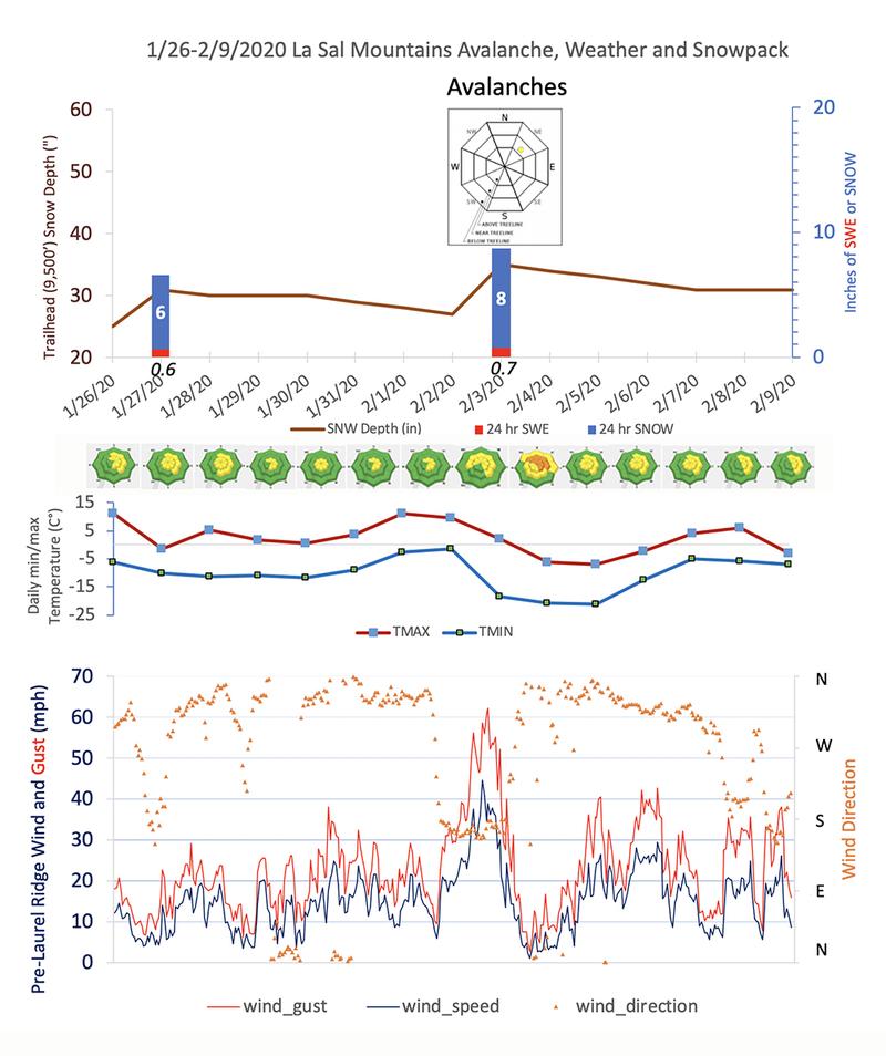
Today's increase in winds would normally sound the alarm but with so little snow available for transport on the scoured and crusted southerly aspects, I don't anticipate much of a rising threat from fresh deposits of wind drifted snow. It's possible I'm underestimating this threat, so always be on the lookout for blowing and drifting snow and look for signs of instability such as cracking in the snow surface.
Persistent Weak Layer: Shallow snowpack areas are developing weak layers of loose, sugary, faceted snow. You are most likely to find these weak layers on rocky, or sparsely wooded northerly facing slopes where the snowpack is less than about 4' deep. Faceted snow is also developing near the surface, or underneath a variety of crusts that exist out there. Though not posing much of a threat at this time, this will become a concern with future snow loads.
Additional Information
Local observer, and environmental sedimentologist Chris Benson, has prepared these charts to track avalanche, weather, and snowpack data over the past 2 weeks. It's a great way to see the history of what's been going on up there, and how weather events correspond to the daily danger rating. Snow data is from the Snotel site at the Geyser Pass Trailhead at 9600'. This site receives considerably less snow than the Gold Basin plot at 10,000', but it also measures Snow Water Equivalent (SWE), or water weight within the snow. This measurement is far more important to avalanche forecasters than snow amounts. Thanks Chris!
General Announcements
My radio interview on KZMU about the history of backcountry skiing in the La Sals, avalanche accidents, and unique snowpack has been saved in perpetuity. You can listen to it here.
Check out the avalanche beacon training park at the Geyser Pass Trailhead and practice your rescue skills!
This forecast is from the U.S. Forest Service, which is solely responsible for its content. This forecast describes general avalanche conditions and local variations always occur.