Sign Up for the Utah Snow and Avalanche Workshop (USAW) on December 7th!

Forecast for the Moab Area Mountains

Eric Trenbeath
Issued by Eric Trenbeath on
Sunday morning, February 11, 2024
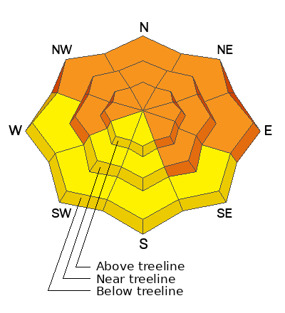
The avalanche danger remains CONSIDERABLE on steep slopes that face W-N-E-SE and human triggered avalanches are likely in these areas. The danger is most acute on slopes facing NW-N-E where recent and wind drifted snow has overloaded buried persistent weak layers deep in the snowpack. Un-survivable, human triggered avalanches 3'-6' deep are likely in these areas.

A MODERATE danger exists on SW-S facing slopes, and on all slopes facing the south side of the compass at low elevations. In these areas, avalanches involving recent and wind drifted snow are possible. On W and SE aspects, it may be possible to trigger a deeper avalanche.
Low
Moderate
Considerable
High
Extreme
Learn how to read the forecast here
Special Announcements
Road Conditions: The Geyser Pass Road was plowed yesterday. Icy and very slick conditions exist on the Loop Road after yesterday's afternoon squall.
Grooming: Gavin ran his snowcat over all trails after the GCSAR training and conditions will be great today.
A huge shout out to Grand County Search and Rescue for putting in the time and effort to pull off a successful avalanche rescue training yesterday!
Weather and Snow
6:00 a.m. Snow and Weather Data
24 Hour Snow 0" 72 Hour Snow 8" Season Total Snow 131" Depth at Gold Basin 57"
Winds on Pre-Laurel Peak: N 5-15 TempPercent of Normal: 113%

Weather
Bluebird conditions are on tap for today as high pressure builds over the region. Early morning temperatures are in the low single digits with mountain highs today in the low 20's. Light northerly winds will shift to the east and then south. It looks like a dry week ahead with gradually warming temperatures.
General Conditions
Close to 3' of snow has fallen over the past week and conditions are all time. They are also very dangerous, particularly on northerly aspects where recent and wind drifted snow over the past week have produced numerous natural avalanches stepping down into buried persistent weak layers, and at least one very large, likely human triggered avalanche. There's some uncertainty out there with a few avalanches in surprise locations, and some layers of weak, faceted snow starting to appear higher up in the snowpack. Give the snowpack time to adjust. Practice conservative decision making and continue to avoid slopes steeper than 30 degrees that face W-N-E-SE. On southerly aspects, avalanches are still possible. Avoid steep slopes in these areas that have a smooth, rounded appearance, and look for signs of instability such as cracking in the snow surface.
Check out the "Week in Review" video below for skiing and avalanche highlights.
Snowpack and Weather Data
Gold Basin Storm Stake (10,000')
Gold Basin SNOTEL site (10,000')
SNOTEL site near Geyser Pass Winter Trailhead (9600')
Wind Station on Pre-Laurel Peak (11,400')
NWS forecast for the La Sal Mountains.
Recent Avalanches
Many natural avalanches and one large, likely human triggered avalanche have occurred over the past week. See the full list here.
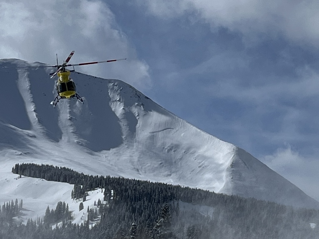
While working with GCSAR yesterday, I took this photo of Classic Helicopters with an avalanche on the north face of Mount Mellenthin that likely ran on Wednesday. The crown line runs all the way down to the observer's right shoulder of the ridge.
Ad
Avalanche Problem #1
Persistent Weak Layer
Type
Location
Likelihood
Size
Description
Persistent weak layers that formed in November and December have reared their ugly heads producing numerous deep and dangerous avalanches over the past week. Human triggered avalanches failing on these weak layers remain likely on steep slopes facing W-N-E-SE. On steep, wind loaded, northerly aspects, human triggered avalanches are still very likely. These are very dangerous avalanches, and would most likely be unsurvivable. We are also starting to observe weak, faceted layers higher up in the snowpack, and we have some uncertainty about how widespread these layers are distributed. Give the snowpack time to adjust. Practice conservative decision making, and stick to low angle slopes (less than 30 degrees) for safe and fun riding today.
Avalanche Problem #2
New Snow
Type
Location
Likelihood
Size
Description
Up to 3' of snow has fallen over the past week. Human triggered avalanches within the recent snow remain possible on steep slopes on all aspects today. But by far, the greatest concern remains on steep slopes facing the north side of the compass where winds have drifted snow into slabs 1'-2' thick adding stress to buried persistent weak layers in the snowpack. Deep and dangerous avalanches remain likely in these areas and this terrain should be avoided.
Additional Information
Want some more insight into the La Sal Mountains as well as the communal impacts of a tragic avalanche? Check out the latest UAC podcast with forecaster Eric Trenbeath where he discusses the range, it's often treacherous snowpack, and how the devastating avalanche in February, 1992, affected the Moab community.
Our avalanche beacon checker sign and beacon training park are up and running. A huge thanks to Talking Mountain Yurts for sponsoring those this season!
Sign up for forecast region-specific text message alerts. You will receive messages about changing avalanche conditions, watches, warnings and road plowing closures.
Follow us on Instagram @utavy_moab
General Announcements
This forecast is from the U.S.D.A. Forest Service, which is solely responsible for its content. This forecast describes general avalanche conditions and local variations always occur.