Forecast for the Moab Area Mountains

Eric Trenbeath
Issued by Eric Trenbeath on
Wednesday morning, December 4, 2019
Today there is an isolated or MODERATE danger for human triggered avalanches on a buried persistent weak layer on steep slopes facing NW-N-E. There also remains an isolated possibility of triggering an old, hard wind slab on steep, upper elevation, northerly facing terrain. Most other terrain offers LOW danger. Expect an increasing danger by tomorrow with an approaching storm.
Low
Moderate
Considerable
High
Extreme
Learn how to read the forecast here
Special Announcements
The road is plowed to Geyser Pass Trailhead.
The First Annual Avalanche Awareness Week is December 2-7 We have a week full of fun and educational events planned. Check out the schedule here.
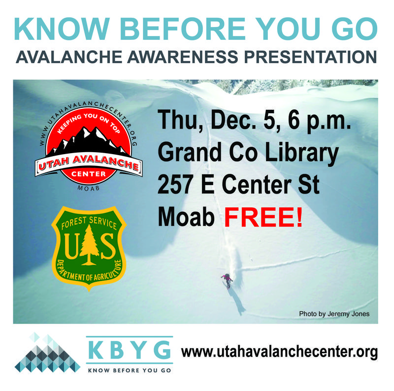
The annual free Know Before You Go avalanche awareness talk will be held at the Grand County Library on Thursday, Dec 5 at 6:00 p.m. Hope to see you there!
Weather and Snow
Gold Basin is showing some crazy snow totals overnight after I cleared the board yesterday. No precipitation has been recorded at Geyser Pass Trailhead, and NWS assures me that what it's showing isn't possible, so let's assume we didn't get any snow last night. If we did, all bets are off and this forecast is null and avoid! SW winds have been mostly light with a slight increase this morning. They are currently averaging 15 mph with gusts in the low 20's. Skies are mostly cloudy and it's 24 degrees at 10,000'.
Clouds will continue to build today as the next storm system approaches our area. We'll see a chance of showers later today with SW winds averaging 15-20 mph along ridge tops. high temps at 10,000' will be around 30 degrees. The real action starts late tonight and we should get a good shot of snow out of this. It looks like 6"-10" with maybe up to a foot possible.
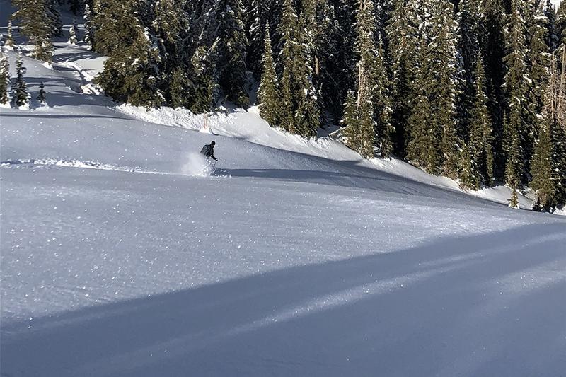
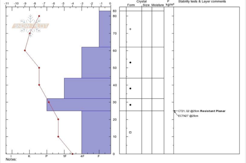
Conditions are as good as I've ever seen for this time of year. Total depth in Gold Basin is 37" while up high there is more than 4' of snow on sheltered slopes. Wind and sun have taken a toll on exposed surfaces, but nice, soft powder is still abundant in sheltered locations.
Wind, temperature, humidity on Pre Laurel Peak (11,700')
Storm totals at Gold Basin Study Plot (10,000').
Snotel site near Geyser Pass Trailhead (9600').
NWS weather forecast.
Recent Avalanches
No recent avalanche activity has been observed since after the Thanksgiving storm.
Ad
Avalanche Problem #1
Persistent Weak Layer
Type
Location
Likelihood
Size
Description
Generally speaking, our snowpack is stacking up about as good as can be hoped for. We had no snow on the ground until Nov 20, when we picked up 6"-12" of dense, heavy snow. That was followed by 25" on the 26th, and then a whopping 33" on the 29th! As a result, we do not have the dreaded loose, sugary, faceted weak layer at the base of the snowpack that we had last season, and that the rest of the state currently has. Nevertheless, some faceting has occurred in the basement. Extended column tests are not producing propagation on this layer, but it is worth paying attention to, especially in areas where a dense, hard slab can be found on top. See this observation from Dave Garcia.
Avalanche Problem #2
Wind Drifted Snow
Type
Location
Likelihood
Size
Description
Isolated, unstable areas of wind drifted snow may still exist on steep slopes that face NW-N-E at the highest elevations. Wind drifts are recognizable by their smooth, rounded appearance and cracking is a sign of instability. Old, hard wind slabs often feel hollow like a drum. Expect fresh wind drifts tomorrow with the new snow.
General Announcements
This forecast is from the U.S. Forest Service, which is solely responsible for its content. This forecast describes general avalanche conditions and local variations always occur.