Forecast for the Moab Area Mountains

Eric Trenbeath
Issued by Eric Trenbeath on
Wednesday morning, December 25, 2019
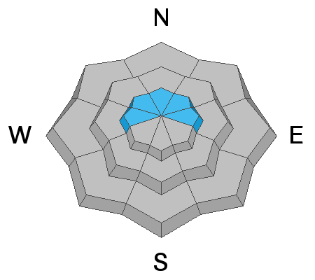
The avalanche danger is CONSIDERABLE and human triggered avalanches are likely on steep, upper elevation, wind drifted slopes that face W-N-E. Wind drifts are recognizable by their smooth, rounded appearance and cracking is a sign of instability. Avoid steep slopes with recent deposits of wind drifted snow. Human triggered avalanches within the storm snow are also possible and the danger is MODERATE on steep slopes on all aspects. Storm snow avalanches can either come in the form of loose sluffs, or cohesive soft slabs. And finally, a triggered wind drift, or storm snow avalanche may have the potential to step down into a buried, persistent weak layer causing a deeper and more dangerous avalanche. Be conservative in your terrain selection today and allow the new snow to settle in and adjust.
Low
Moderate
Considerable
High
Extreme
Learn how to read the forecast here
Special Announcements
Road Conditions: The road will not be plowed today. Expect up to 6" of snow at the trailhead.
Grooming update: Matt will be headed up today to roll out the new snow.
Weather and Snow
24 Hour Snow 12" Weekly Snow 12" Base Depth in Gold Basin 39" Wind SW 10-20 mph Temp 20F
A white Christmas has come to the mountains! Readings have been haywire since 0500 indicating a period of intense snowfall this morning but it's safe to say we've picked up at least a foot of snow above 10,000'. SE winds blew in the 20 mph range with gusts into the 30's for most of the day yesterday. They continued through the night before dropping off and shifting to the SW around 0300. They are currently averaging 10-15 mph with gusts in the low 20's. It's 20 degrees at 10,000'.
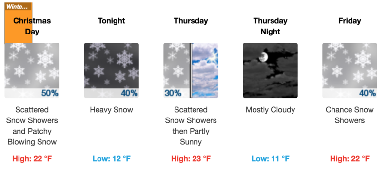
Today look for lingering snow showers, light to moderate SW winds, with high temps in the low 20's. A moist, southwesterly flow will keep the possibility for snow showers going through Thursday. On Friday, a closed Pacific low will move across Arizona. How it will affect us remains uncertain.
Wind, temperature, humidity on Pre Laurel Peak (11,700')
Storm totals at Gold Basin Study Plot (10,000').
Snotel site near Geyser Pass Trailhead (9600').
NWS weather forecast.
Ad
Avalanche Problem #1
Wind Drifted Snow
Type
Location
Likelihood
Size
Description
More than a foot of new snow combined with moderate to strong southerly winds will have created fresh wind drifts that will be sensitive to the weight of a skier or rider today. Look for recent deposits of wind drifted snow on the leeward sides of ridge crests and terrain features on upper elevation slopes that face the north half of the compass. Wind drifts are recognizable by their smooth, rounded appearance, and cracking in the snow surface is a sign of instability.
Avalanche Problem #2
New Snow
Type
Location
Likelihood
Size
Description
Human triggered avalanches within the new snow may be possible today. These can occur in the form of loose snow sluffs, or as soft cohesive slabs on steep slopes that have more than about 8" of new snow. I have a fair amount of uncertainty about this - many old snow surfaces are scoured and textured and the new snow should bond well in these areas. In areas where the old snow surface was slick and hard, or loose and weak, we could see avalanching within the new snow. The only real way to know will be to get out and see how the new snow is reacting or simply give it time to adjust.
Avalanche Problem #3
Persistent Weak Layer
Type
Location
Likelihood
Size
Description
Weak layers have been observed developing within the snowpack over the past week to 10 days. I'm uncertain to what extent the new snow will affect them. My inclination is that there is the likelihood for wind drifted snow to affect weak layers in the upper portion of the snowpack. That said, travel advice remains the same - steep wind drifted slopes should be avoided. A triggered wind drift has the potential to step down into a buried weak layer.
General Announcements
Get one of these cool t-shirts to support the UAC and other avalanche centers across the U.S.
This forecast is from the U.S. Forest Service, which is solely responsible for its content. This forecast describes general avalanche conditions and local variations always occur.