Sign Up for the Utah Snow and Avalanche Workshop (USAW) on December 7th!

Forecast for the Moab Area Mountains

Eric Trenbeath
Issued by Eric Trenbeath on
Sunday morning, December 24, 2023
A significant load of snow yesterday combined with increasing winds overnight has elevated the danger to CONSIDERABLE on steep, upper elevation slopes that face NW-N-E. In these areas, human triggered soft slabs of recent and wind drifted snow are likely. Triggered slabs also have the potential to step down into buried weak layers of sugary, faceted snow.

A MODERATE danger exists at mid-elevations on steep slopes facing W-N-E.

Most avalanche terrain is difficult to access due to low snow conditions, but if a slope looks like it has enough snow to ride, it has enough to slide. Suspect the deepest snow areas on the leeward sides of ridge crests and terrain features, and avoid steep, freshly loaded slopes on the north half of the compass.
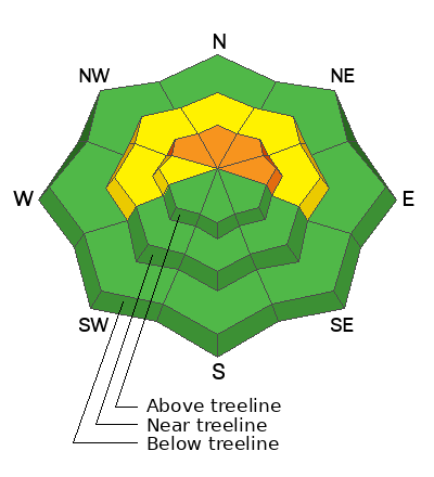
Low
Moderate
Considerable
High
Extreme
Learn how to read the forecast here
Special Announcements
The Geyser Pass Road will be covered in a few inches of fresh snow over a snowpacked surface. AWD and good tires required.
Grooming: Groomer extraordinaire, Gavin Harrison ran the snowcat into Gold Basin and up over Geyser Pass yesterday and trails are in excellent condition.
Weather and Snow
6:00 a.m. Snow and Weather Data
24 Hour Snow 8" 72 Hour Snow 8" Season Total Snow 42" Base Depth at Gold Basin 26"
Winds on Pre-Laurel Peak: NW20 Temp 5˚ F

Weather
Skies have cleared, winds have shifted and are blowing out of the northwest, and temperatures have plummeted. Look for sunny skies and unseasonably cold temps today with a high of 20 degrees at 10,000'. Ridge top NW winds will average 10-15 mph adding to the wind chill. Dry conditions return for the foreseeable future.

General Conditions
Yesterday's 8" of new snow came with an inch of water weight, or Snow Water Equivalent (SWE) which was more than I anticipated. That much water typically translates to 10"-12" of snow in our region. This is a significant load for our shallow, weak, and faceted snowpack and I may have underestimated the danger yesterday, primarily on mid and upper elevation, northerly aspects. In my travels today I'll be looking for signs of instability such as collapsing and "whumphing" of the snowpack. This means that the underlying weak snow has failed under the recent load. The bottom line is it's early, the snowpack is shallow, weak, and has a fresh load on it. Any avalanche triggered would be a rough and bumpy ride, and you are advised to avoid, steep, northerly aspects at this juncture. Additionally, rocks, stumps and deadfall are lurking everywhere. Stick to roads and known grassy meadows and low angle slopes.
Check out this video of Dave Garcia describing the underlying snowpack prior to this storm:
Snowpack and Weather Data
Gold Basin Storm Stake (10,000')
Gold Basin SNOTEL site (10,000')
SNOTEL site near Geyser Pass Winter Trailhead (9600')
Wind Station on Pre-Laurel Peak (11,400')
NWS forecast for the La Sal Mountains.
Recent Avalanches
No recent avalanches have been reported.
Ad
Avalanche Problem #1
New Snow
Type
Location
Likelihood
Size
Description
Human triggered avalanches involving slabs of recent and wind drifted snow are likely today. The danger is most acute on steep, upper elevation, northerly aspects, but freshly loaded slopes facing W-N-E at mid-elevations are also suspect. Avalanches triggered in the recent snow have the potential to step down into weaker faceted layers. I'll be out and about today getting a better handle on this situation but it seems likely that we have a developing persistent weak layer problem. For more on that, see details below under Additional Information.
Additional Information
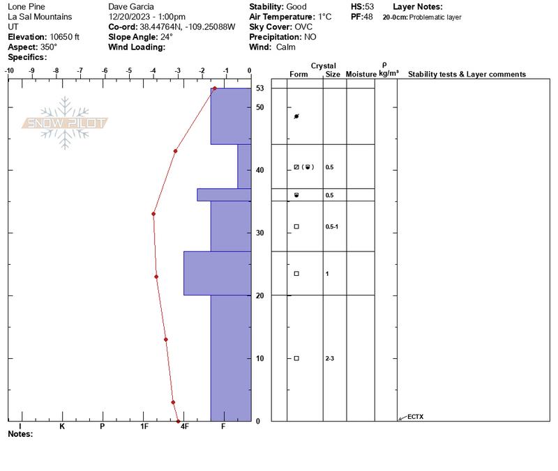
The underlying snowpack has turned into weak, sugary facets on northerly aspects. Time will tell how big of a problem this becomes, but we'll be keeping an eye on it. For now, it's primarily a concern in upper elevation, northerly facing terrain where winds have drifted slabs over top. Most of the areas where you would encounter a problem are difficult to access because of the low coverage, but if you find yourself in the upper elevations, remember that if it has enough snow to ride, it has enough snow to slide. Suspect the deepest snow areas on the leeward sides of ridge crests and terrain features. Even a small avalanche triggered could take you for a very bumpy ride.
The snowpit below illustrates the weak, fragile nature of the underlying snowpack. This will undoubtedly become a persistent weak layer problem as snow accumulates on top.
General Announcements
This forecast is from the U.S.D.A. Forest Service, which is solely responsible for its content. This forecast describes general avalanche conditions and local variations always occur.