Check out our Holiday Auction - Sign Up for the Utah Snow and Avalanche Workshop (USAW)

Forecast for the Moab Area Mountains

Eric Trenbeath
Issued by Eric Trenbeath on
Saturday morning, December 17, 2022
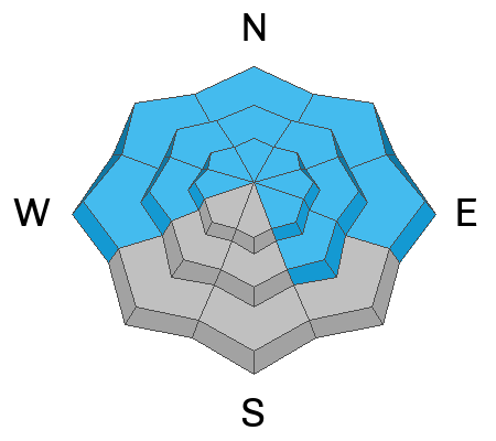
The avalanche danger remains CONSIDERABLE on steep, wind drifted slopes that face NW-N-E and dangerous, human triggered avalanches, failing on a buried persistent weak layer 2'-4' deep are likely. Slopes steeper than 30 degrees should be avoided in this terrain. A MODERATE danger for this type of avalanche exists on slopes facing W and SE, and on low elevation northerly aspects.
NW winds at upper elevations are blowing and drifting this week's low density snow, and a MODERATE danger for triggering an unstable slab of wind drifted snow exists on all aspects above treeline.
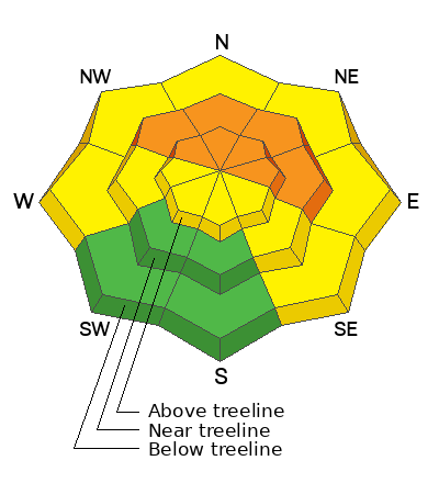
Low
Moderate
Considerable
High
Extreme
Learn how to read the forecast here
Special Announcements
Dangerous avalanche conditions exist throughout the state and three accidents involving injuries have occurred over the past week.
Loafer Canyon, Payson: DETAILS HERE
Pink Pine, SLC Mtns: DETAILS HERE
Neffs Canyon, SLC Mtns: DETAILS HERE
Road Conditions: A few inches of snow has fallen on the road since Grand County plowed on Tuesday but it has been well packed in by traffic. It is slick, and AWD and good tires are required.
Grooming: Matt groomed all trails yesterday.
Weather and Snow
24 Hour Snow 0" 72 Hour Snow 10" Season Total Snow 79" Base Depth at Gold Basin 49"
Winds on Pre Laurel Peak NW 25-30 Temp 2F
Weather
NW winds began ramping up after midnight and are blowing 25-30 mph along high ridge tops. Down lower they'll be blowing around 10 mph today where they will add to the chill in the air. Under sunny skies, high temps at 10,000' will creep up into the lower teens. A cut off low diving well south will bring a few clouds on Sunday, and around Wednesday a weak system passes by to the north. Mostly dry conditions are on tap for our area for the foreseeable future.

General Conditions
Storm totals for the week are up to 24" at 1.8" of Snow Water Equivalent (SWE) and conditions remain excellent if not a little thin. NW winds will have an effect on the snow surface in exposed terrain, and some southerly aspects have developed a crust. The avalanche danger is slowly dialing down, but a persistent weak layer of faceted snow exists on slopes facing W through N-SE. On slopes facing NW-N-E, wind loading has built hard slabs on top of this weak layer, and deep and dangerous, human triggered avalanches remain likely.
Conditions report from Wednesday, Dec 14.

Snowpack and Weather Data
Gold Basin Storm Stake (10,000')
Gold Basin SNOTEL site (10,000')
SNOTEL site near Geyser Pass Winter Trailhead (9600')
Wind Station on Pre-Laurel Peak (11,400')
NWS forecast for the La Sal Mountains.
Click here for a list of recent observations. If you're getting out in the backcountry please let us know what you are seeing by submitting observations here.
Recent Avalanches
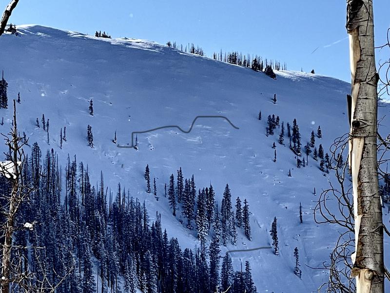
Keen eyed observer Tim Mathews noticed this natural avalanche on Noriega's Face yesterday. It likely ran during the Tuesday night storm event.
Ad
Avalanche Problem #1
Persistent Weak Layer
Type
Location
Likelihood
Size
Description
A persistent weak layer of faceted snow that developed during the cold dry period in mid November exists on aspects that face W-N-SE. Incremental loading from recent and wind drifrted snow has kept the pressure on this weak layer but the danger is slowly decreasing. The greatest danger exists on slopes facing NW-N-E, where wind drifted snow has built thick slabs on top. These hard slabs are 1-4' thick and can produce very large, deep, and potentially deadly avalanches. Slopes steeper than 30 degrees should be avoided in these areas.
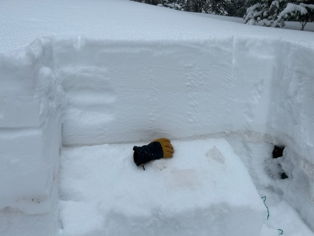
The buried weak layer sits right behind the glove in this photo. If you dig down, it is easy to locate because of the brown dust in the layer.
Avalanche Problem #2
Wind Drifted Snow
Type
Location
Likelihood
Size
Description
Increased NW winds at upper elevations continue to blow and drift the recent snow, creating potentially unstable slabs on all aspects above treeline. Areas of wind drifted snow are recognizable by their smooth, rounded appearance, and cracking is a sign of instability. On northerly aspects, recent drifts will only add more stress to the buried persistent weak layer, and steep northerly facing terrain should be avoided due to the possibility of a much deeper and more dangerous avalanche.
Additional Information
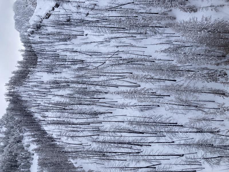
The Neff's Canyon Accident up in SLC got Dave and I talking. It occurred on a lower elevation, northerly aspect with burned out trees. This is similar terrain to what exists in the burned out section of the North Woods. Slope angles hover in the low 30's but do reach 35 degrees in places. This is avalanche terrain, and it harbors weak, faceted snow. It should not be considered safe.
General Announcements
This forecast is from the U.S.D.A. Forest Service, which is solely responsible for its content. This forecast describes general avalanche conditions and local variations always occur. This forecast will be updated by 7:30 tomorrow morning.