Check out our Holiday Auction - Sign Up for the Utah Snow and Avalanche Workshop (USAW)

Forecast for the Moab Area Mountains

Eric Trenbeath
Issued by Eric Trenbeath on
Saturday morning, January 28, 2023
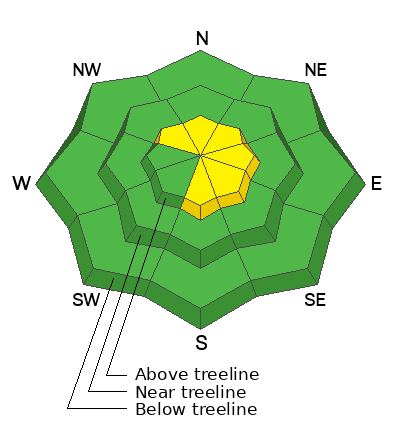
A MODERATE danger exists for human triggered avalanches involving unstable slabs of wind drifted snow on steep slopes above treeline. Recent deposits of wind drifted snow are often recognizable by their smooth, rounded appearance, and cracking is a sign of instability.

In non-wind affected terrain the avalanche danger is generally LOW.

Human triggered avalanches failing on a buried persistent weak layer are now very unlikely. They may still be possible in thinner snowpack areas, and in areas of very steep, rocky, radical terrain.
Low
Moderate
Considerable
High
Extreme
Learn how to read the forecast here
Special Announcements
Geyser Pass Road: Work has been halted and the road is open through the weekend. Narrow spots still exist, use turnouts. Work will resume on Monday.
Grooming: LUNA has been actively grooming over the last few days and all trails are set with classic track.
Weather and Snow
24 Hour Snow 0" 72 Hour Snow 4" Season Total Snow 178" Base Depth at Gold Basin 73"
Winds on Pre Laurel Peak SW 5-15 Temp 17F

Weather
An active pattern on a westerly flow is bringing heavy snow to the northern and central Rockies. For our area today, we'll see mostly cloudy skies with a chance for an inch or two of snow. Westerly winds should be mostly light and high temps will be in the mid to upper teens. Southwesterly winds will be on the increase tonight, with cloudy and blustery conditions on tap for Sunday as an upper level low pressure system moves into the Great Basin. As the trough sags further south, we'll see our best chance for a few inches of snow on Monday

General Conditions
Good, settled powder conditions are still plentiful but winds have begun to take their toll in exposed areas. Shifting winds throughout the week have blown and drifted snow on to all aspects above treeline, and unstable slabs of wind drifted snow may be found on the leeward sides of ridge crests and terrain features such as gully walls and sub-ridges in wind affected terrain.
It's now been more than a week since the last observed avalanche that failed on the November persistent weak layer (PWL). Somewhat of an outlier, this avalanche occurred in a shallow snowpack area, and was triggered by a very significant loading event. It is very unlikely that the weight of a skier or rider would trigger such a slide, but it still may be possible in outlying areas that have a combination of radical terrain and a thinner, weaker snowpack.
UAC Executive Director Chad Brackelsberg and I took sleds over to the east side of the range on Thursday. See my report in the video below. Chad was also up again yesterday and he sent in this observation.
For more snowpack information see a complete list of observations here.

Snowpack and Weather Data
Gold Basin Storm Stake (10,000')
Gold Basin SNOTEL site (10,000')
SNOTEL site near Geyser Pass Winter Trailhead (9600')
Wind Station on Pre-Laurel Peak (11,400')
NWS forecast for the La Sal Mountains.
Recent Avalanches
A few small avalanches involving new and wind drifted snow have been observed over the past several days but have not been detailed. For a further list of avalanches see the La Sal Avalanche database here.
Ad
Avalanche Problem #1
Wind Drifted Snow
Type
Location
Likelihood
Size
Description
Steady winds throughout the week has kept the threat of human triggered avalanches involving wind drifted snow alive above treeline. Be on the lookout for unstable slabs of wind drifted snow on the leeward sides of ridge crests and terrain features such as gully walls and sub-ridges in wind affected terrain. Fresh drifts often have a smooth, rounded appearance and cracking is a sign of instability.
Older drifts that formed over the last few days have stiffened up and are now mostly stuck in place, but steep slopes that have a smooth, rounded, "fat" appearance should still be approached with caution. Consider the consequences of the terrain you are in.
Avalanche Problem #2
Persistent Weak Layer
Type
Location
Likelihood
Size
Description
The La Sal snowpack is now generally deep and mostly stable with the November persistent weak layer buried far below the surface. Snow pits dug to this depth show that the layer has gained strength, and that the overriding slab is very thick and strong. It is very unlikely that the weight of a skier or rider would trigger a deep avalanche but it still may be possible in outlying areas that have a combination of radical terrain and a thinner, weaker snowpack. If you are venturing into larger terrain, pull out your probe. If the snowpack is 150 cm, or about 5' deep or less, this is where you need to look closer. In these areas, a slab about 3' thick exists over the November PWL, and this structure indicates a higher likelihood for a human triggered avalanches.
Additional Information
General Announcements
This forecast is from the U.S.D.A. Forest Service, which is solely responsible for its content. This forecast describes general avalanche conditions and local variations always occur. This forecast will be updated by 7:30 tomorrow morning.