Forecast for the Moab Area Mountains

Eric Trenbeath
Issued by Eric Trenbeath on
Monday morning, January 20, 2020
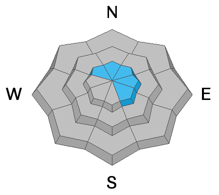
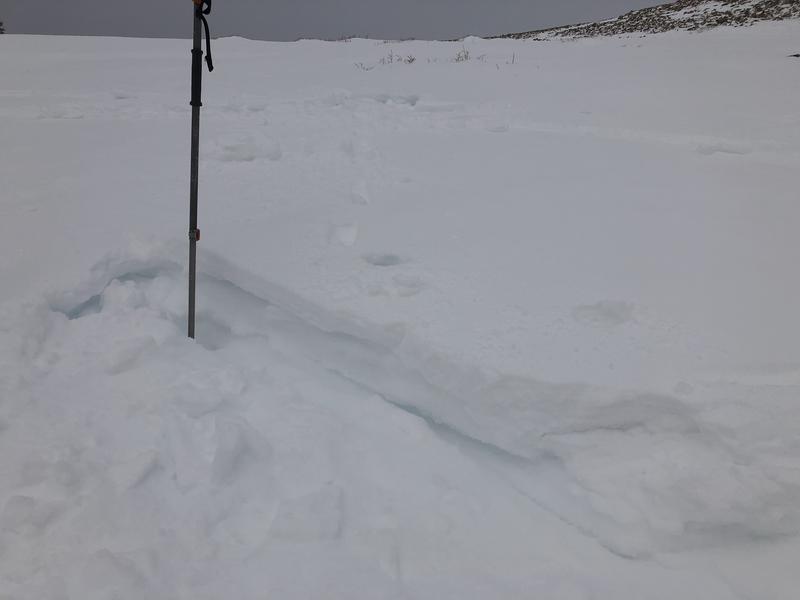
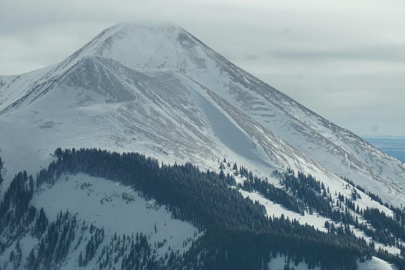
The avalanche danger is MODERATE on steep, upper elevation, wind drifted slopes that face NW-N-SE. The danger is generally isolated and spotty, with drifted areas existing between heavily scoured surfaces. Suspect slopes that have a smooth, rounded appearance or that feel and sound hollow like a drum. Non-wind loaded slopes have generally LOW danger.
Low
Moderate
Considerable
High
Extreme
Learn how to read the forecast here
Special Announcements
We are very sad to report an avalanche fatality that happened on Saturday, January 18, above Farmington Canyon. An 18-year-old, male snowmobiler was caught, fully buried and killed. Preliminary info available HERE. forecasters re-visited the scene on Sunday and we'll have a full report available in the coming days. Our deepest condolences go out to the friends, family, rescuers, and everyone affected by this tragic accident.
You can listen to my radio interview with Lisa Hathaway on KZMU by clicking here then selecting Mon, Jan 13, then scroll down and play "Thought for Food/Public Affairs."
Our Backcountry 101 avalanche course has been scheduled for February 15, 16. The cost is $150. The course starts with a 4-hour classroom session the night of the 15th followed by a day in the field. It's a great way to increase your avalanche awareness and backcountry travel skills. Click here to register. A huge thanks to Moab Gear Trader for sponsoring this course. Please visit them for all your winter backcountry needs
Road Conditions: The road has not been plowed and ruts through windblown and drifted snow are forming near the top.
Grooming update: Matt groomed on Saturday. Cross country skiing may be the best game in town right now!
Weather and Snow
24 Hour Snow 0" Weekly Snow 2" Base Depth in Gold Basin 40" Wind SSE 5-10 mph Temp 18F
It was a nice day in the mountains yesterday with sunshine, a few high clouds, and light northwesterly winds. Look for increasing clouds and southerly winds today ahead of a Pacific trough moving into the region. High temps will be near 30 degrees. Light showers could begin late tonight but the main energy should arrive tomorrow morning. It's not a big storm but we'll take what we can get. 2"-4" are possible.
If you've been following the forecast you've seen my reports on less than desirable, wind-blasted snow conditions. The intrepid, however, have been finding soft snow in sheltered locations, and yesterday, I was pleasantly surprised over on the east side of the range where I found 8"-10" of soft, settled powder that has been slowly accumulating out of the wind zone. More on that in the video below.
Wind, temperature, humidity on Pre Laurel Peak (11,700')
Storm totals at Gold Basin Study Plot (10,000').
Snotel site near Geyser Pass Trailhead (9600').
NWS weather forecast
Recent Avalanches
Our aerial observer Chris Benson was flying around on Saturday and he noted a significant natural avalanche on north-facing South Mountain that likely occurred during the high wind event of early last week. He did not observe any other activity in his travels.
Ad
Avalanche Problem #1
Wind Drifted Snow
Type
Location
Likelihood
Size
Description
Isolated wind slabs remain scattered throughout the high country. The most recent storm snow has been deposited into fresh drifts between 4"-8" deep, primarily on slopes with an easterly component but cross-loading has occurred as far around as the NW. The strong and shifting nature of the wind has caused these deposits to form further downslope, and you aren't as likely to find them right along ridge crests. Many ridge crests have been scoured clean, and in some cases, slabs have formed adjacent to bare ground. Slabs formed early in the week are hard and stubborn at this point, but avalanches ranging from a few inches up to 18" deep remain possible. Be on the lookout for cracking in the snow surface and suspect smooth, rounded pillows, and harder surfaces that feel and sound hollow like a drum.
Fresh drift within the most recent storm snow.
Note the cross-loaded, NW facing gully in shadow in the center of the photo. Areas like this can have hard wind slabs that can be triggered adjacent to slopes with bare ground. Chris Benson photo.
Additional Information
Wind slab danger notwithstanding, the state of our overall snowpack on northerly aspects is looking good. Last Tuesday, pro observers Dave Garcia, Nate Ament and I dug a full depth pit on a north aspect at around 10,800'. The season snowfall history can be clearly detailed. The only weak layers we observed are at storm interfaces that have occurred since Christmas Eve. These have been non-reactive for some time and are showing a general trend towards strengthening. Since we didn't get early season snow, we are blessed to not have a layer of weak, sugary facets, or depth hoar at the base of the snowpack. The facets that do exist at the base of the pack are small-grained and are rounding which signals a trend toward strengthening.
I've included both a Photoshop profile and Dave Garcia's Snowpilot profile so you can compare the two and see how they correlate. The hand hardness tests you see in the photo are noted along the bottom of the Snowpilot profile as fist (F), four finger (4F), one finger (1F), pencil (P), and knife (K). In this way you can see how the snowpack generally gains strength as it goes down. Also note the weak interfaces at 67, 80, and 102 cms.
General Announcements
Check out the avalanche beacon training park at the Geyser Pass Trailhead and practice your rescue skills!
This forecast is from the U.S. Forest Service, which is solely responsible for its content. This forecast describes general avalanche conditions and local variations always occur.