Forecast for the Moab Area Mountains

Eric Trenbeath
Issued by Eric Trenbeath on
Saturday morning, January 18, 2020
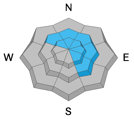
The avalanche danger is MODERATE at mid and upper elevations on steep, wind drifted slopes that face NW-N-SE. Look for shallow drifts in the most recent snow that could become problematic if more than about 6" deep. In some cases, fresh drifts may cover older wind slabs that formed earlier in the week. Suspect slopes that have a smooth, rounded appearance or that feel and sound hollow like a drum. Non-wind loaded slopes have generally LOW danger.
Low
Moderate
Considerable
High
Extreme
Learn how to read the forecast here
Special Announcements
You can listen to my radio interview with Lisa Hathaway on KZMU by clicking here then selecting Mon, Jan 13, then scroll down and play "Thought for Food/Public Affairs."
Our Backcountry 101 avalanche course has been scheduled for February 15, 16. The cost is $150. The course starts with a 4-hour classroom session the night of the 15th followed by a day in the field. It's a great way to increase your avalanche awareness and backcountry travel skills. Click here to register. A huge thanks to Moab Gear Trader for sponsoring this course. Please visit them for all your winter backcountry needs
Road Conditions: The road has not been plowed and ruts through windblown and drifted snow are forming near the top.
Grooming update: 2" of snow has fallen since Matt groomed on Thursday. Grooming is scheduled for this afternoon.
Weather and Snow
24 Hour Snow 2" Weekly Snow 5" Base Depth in Gold Basin 40" Wind WNW 10-15 mph Temp 5F
A fast but intense period of snow and wind moved through yesterday morning leaving 2" of snow in the mountains. Strong SW winds cranked through the morning before backing off and shifting to the NW around noon. This morning, skies are clear, temps are cold, and NW winds are light. A dirty ridge of high pressure will build over the area, bringing dry and calm conditions through the weekend. A weak, mid-level trough will bring unsettled conditions Tue-Wed. Models haven't come up with a consistent solution yet, but it's not looking like much either way.
The video below was shot early this week, but it will give you a pretty good idea of the overall conditions and what the wind has been doing for the past several days.
Wind, temperature, humidity on Pre Laurel Peak (11,700')
Storm totals at Gold Basin Study Plot (10,000').
Snotel site near Geyser Pass Trailhead (9600').
NWS weather forecast
Recent Avalanches
No new avalanche activity since Sunday's natural slide off the NE face of Tukno, and Monday's skier triggered wind slab at the base of Middle Cirque.
Ad
Avalanche Problem #1
Wind Drifted Snow
Type
Location
Likelihood
Size
Description
Strong southerly winds yesterday morning formed shallow drifts within the most recent snow. These should be pretty manageable but could become problematic if more than about 6" deep. In some cases, fresh drifts will cover harder wind slabs that formed earlier in the week. Older slabs will be stubborn and difficult to trigger, but avalanches ranging from a few inches up to 18" deep remain possible today. Be in the lookout for cracking in the snow surface and suspect smooth, rounded pillows, and harder surfaces that feel and sound hollow like a drum.
Additional Information
Wind slab danger notwithstanding, the state of our overall snowpack is looking good. On Tuesday, pro observers Dave Garcia, Nate Ament and I dug a full depth pit on a north aspect at around 10,800'. The season snowfall history can be clearly detailed. The only weak layers we observed are at storm interfaces that have occurred since Christmas Eve. These have been non-reactive for some time and are showing a general trend towards strengthening. Since we didn't get early season snow, we are blessed to not have a layer of weak, sugary facets, or depth hoar at the base of the snowpack. The facets that do exist at the base of the pack are small-grained and are rounding which signals a trend toward strengthening.
I've included both a Photoshop profile and Dave Garcia's Snowpilot profile so you can compare the two and see how they correlate. The hand hardness tests you see in the photo are noted along the bottom of the Snowpilot profile as fist (F), four finger (4F), one finger (1F), pencil (P), and knife (K). In this way you can see how the snowpack generally gains strength as it goes down. Also note the weak interfaces at 67, 80, and 102 cms.
General Announcements
Check out the avalanche beacon training park at the Geyser Pass Trailhead and practice your rescue skills!
This forecast is from the U.S. Forest Service, which is solely responsible for its content. This forecast describes general avalanche conditions and local variations always occur.