AVALANCHE WARNING!! Tap for info
UDOT PLANNED AVALANCHE CLOSURES!!

Forecast for the Moab Area Mountains

Dave Garcia
Issued by Dave Garcia on
Wednesday morning, January 15, 2025
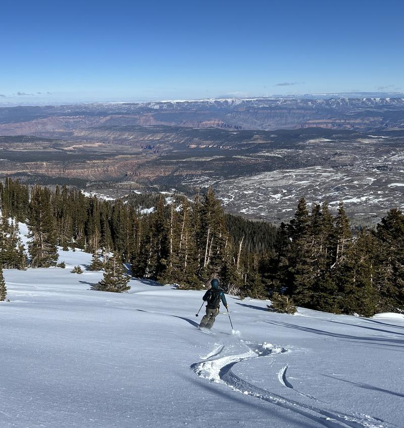
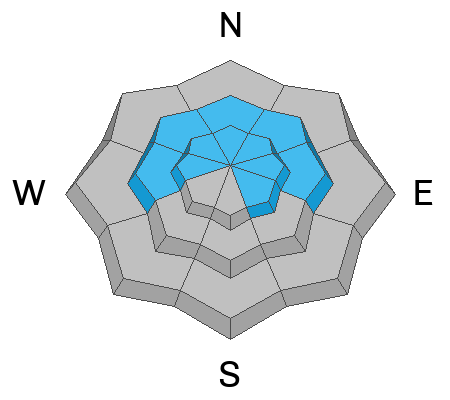
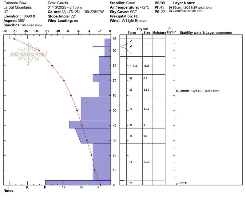
There is a MODERATE danger on steep slopes facing W-N-E-SE where slabs of previously drifted snow overlay a buried persistent weak layer. This instability is most pronounced on near treeline northerlies. People can trigger avalanches up to a foot deep or more in these areas. In alpine terrain, there is a low-likelihood high-consequence scenario of triggering full-depth avalanches failing on a weak layer of facets near the ground. To manage this problem, I am still avoiding big lines in the alpine.

Most other terrain has LOW danger. Small avalanches involving thin slabs of wind-drifted snow may be possible on isolated terrain features.
Many slopes have thin cover and rocks, stumps, and logs are lurking just beneath the surface.
Low
Moderate
Considerable
High
Extreme
Learn how to read the forecast here
Special Announcements
Geyser Pass Road: Surface is mainly snowpacked and icy. AWD with good tires required.
Grooming Conditions: Trails have not been groomed since Friday.
The beacon park is up and running. High pressure is a great time to work on your beacon skills.
Weather and Snow
6 A.M. Snow and Weather Data
24 Hour Snow: 0" 72 Hour Snow: 0" Season Total Snow: 60" Depth at Gold Basin: 29"
Winds on Pre-Laurel Peak: N 13-17 Temp: 7° F Percent of Normal (SWE): 95%
Weather
This morning, under clear skies, it is 7° F in Gold Basin. Overnight winds were light out of the north. Today, the wind will remain light, and blow just 5 MPH out of the northwest. Daytime highs will reach 24° F. A gradual warming trend continues through Friday. Enjoy the warmer temperatures while they last. An arctic cold front arrives Saturday with windy conditions and below normal temperatures. The cold front will bring clouds and some snow flurries, but little to no accumulation is expected.
General Conditions
Yesterday I remarked, "The snow surface is generally wrecked around the compass." While this is mostly true, Travis and I found some great powder skiing yesterday. We got into the alpine and found plenty of hard sastrugi and rocks above treeline. But we scored some soft turns near treeline and below on east and north-facing slopes. Keep the dream alive - if you seek sheltered terrain, there is still some good skiing to be had out there. Solar aspects remain very thin and rocky.
We are still dealing with a persistent weak layer problem involving slabs of previously drifted snow that exist over top of weak faceted layers. The primary layer of concern exists about a foot beneath the surface and is easy to locate with your shovel. You’ll want to avoid steep slopes if you find a slab above this layer.
Travis Nauman proves that there is still some good skiing out there. This is an east-facing slope around 11,000 ft.
Snowpack and Weather Data
Gold Basin SNOTEL site (10,000')
SNOTEL site near Geyser Pass Winter Trailhead (9600')
Wind Station on Pre-Laurel Peak (11,400')
NWS forecast for the La Sal Mountains.
Recent Avalanches
Ad
Avalanche Problem #1
Persistent Weak Layer
Type
Location
Likelihood
Size
Description
The primary avalanche concern is a weak layer of faceted snow that formed during the December dry spell and was buried on 12-25. This layer can be found about a foot below the surface on slopes facing W-N-E-SE. This weak layer is widespread, but the overlying slab is not, and it takes both to make an avalanche. The bullseye location for this instability is near treeline northerlies. You can encounter this weak structure above treeline, however, strong northerly winds have created an erratic distribution of over-riding slabs, stripping and eroding snow off of many north and east aspects that are usually loaded. Cross-loading, however, is still a factor. This means you can be traveling through terrain that looks scoured and benign, and then suddenly find yourself on top of a hard slab with facets underneath. Suspect this scenario when the texture changes from rough and thin, to smooth, hard, and fat. Be alert to likely deposition zones such as gullies, depressions, and the leeward sides of terrain features. In these same areas, an outside chance lingers for avalanches to fail on weak facets near the ground. Avoiding extreme, rocky, slopes with a thin snowpack is the best way to mitigate this problem.
The profile below is from Colorado Bowl on Monday. Notice the very weak snow at the top of the pack. No slab is present in this profile, but on some slopes near treeline and above, slabs have formed on top of this very weak surface snow causing elevated avalanche conditions.
Additional Information
Sign up for text alerts to get the most up to date information about changing conditions, road plowing, special avalanche announcements.
Follow us on Instagram @utavy_moab
General Announcements
This forecast is from the U.S.D.A. Forest Service, which is solely responsible for its content. This forecast describes general avalanche conditions and local variations always occur.