AVALANCHE WARNING!! Tap for info

Forecast for the Moab Area Mountains

Eric Trenbeath
Issued by Eric Trenbeath on
Friday morning, January 10, 2025
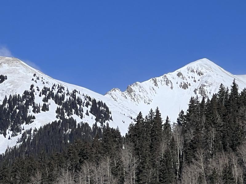
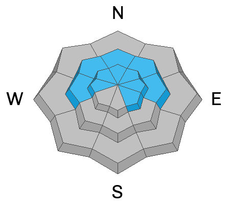
Strong northerly winds have bumped the danger up a notch by making it more widespread. The avalanche danger is MODERATE on steep slopes on all aspects near and above treeline that have recent deposits of wind drifted snow.
The danger is greatest on steep slopes facing W-N-E-SE where recent slabs of wind drifted snow have increased the likelihood for human-triggered avalanches failing on a buried persistent weak layer. In these areas, human triggered avalanches a foot deep or more are possible.
An outlying possibility also exists for full depth avalanches failing on weak facets near the ground. Minimize this type of risk by avoiding thin slope margins and areas of rocky, radical, northerly facing terrain.

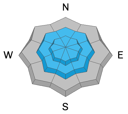
Many slopes have thin cover and rocks, stumps, and logs are lurking just beneath the surface.
Low
Moderate
Considerable
High
Extreme
Learn how to read the forecast here
Special Announcements
Geyser Pass Road: Surface is mainly snowpacked and icy. AWD with good tires required.
Grooming Conditions: Trails were last groomed on Monday.
Weather and Snow
6 A.M. Snow and Weather Data
24 Hour Snow: 0" 72 Hour Snow: 0" Season Total Snow: 58" Depth at Gold Basin: 28"
Winds on Pre-Laurel Peak: N 20-30 G 43 Temp: 5° F Percent of Normal (SWE): 96%
Weather
Yesterday's brutal north winds continued their icy reign of terror through the night and they're still cranking along ridge tops. Six hour average on Pre Laurel Peak is 25 mph with gusting into the low 40's. They should back off here shortly but we'll remain under the influence of cold, northerly flow. Today, look for sunny skies, light NW winds, and high temps creeping up into the low 20's. Another system to the north will bring clouds and a chance for snow on Saturday, followed by high and dry conditions for the foreseeable future.
General Conditions
Reports from the backcountry indicate that snow conditions are thoroughly wrecked. Forest Service Recreation Program Manager Brian Murdock braved conditions yesterday and said that "the wind scoured everything." He also reported fresh drifts in the high country, lots of cross-loading on northerly facing terrain, and even isolated, shallow wind slabs in lower elevation wooded areas. Chris Benson gave a similar report. He also observed shooting cracks and audible collapsing within thin, hard slabs of recently deposited, wind drifted snow. He found weak, faceted snow underneath. Dave Garcia and I will be headed up today to survey the damage.
Although many south facing slopes were thin or bare prior to the north wind event, the ridge between Mounts Peale, and Tukuhnikivatz looks pretty well covered. Recent deposits of wind drifted snow will be a concern on south facing terrain that looks like this. Note snow plumes upper left. Chris Benson photo.
Snowpack and Weather Data
Gold Basin SNOTEL site (10,000')
SNOTEL site near Geyser Pass Winter Trailhead (9600')
Wind Station on Pre-Laurel Peak (11,400')
NWS forecast for the La Sal Mountains.
Recent Avalanches
Ad
Avalanche Problem #1
Persistent Weak Layer
Type
Location
Likelihood
Size
Description
Recent and wind-drifted snow has added additional stress to buried persistent weak layers increasing the likelihood of human-triggered avalanches in some locations. The danger is greatest on steep, wind-loaded, northerly aspects near treeline and above.
A layer of near-surface facets (NSF) formed during the long December dry spell. This layer is now buried about a foot deep and has been sensitive in recent stability tests. It is especially reactive in areas where the wind has drifted enough snow to form a stiff slab on top. Strong winds over the past few days have made this problem more widespread. Human-triggered avalanches are most likely to fail here first and could be 1-3 feet deep in drifted areas. It is important to carefully analyze any slope you are considering by digging down to see if the poor structure exists. Avalanches triggered on this weak layer could also step down into our second faceted weak layer at the base of the snowpack. Avalanches failing on this layer would be deep, dangerous, and possibly un-survivable.
In the video below, Dave Garcia demonstrates the reactive potential in our primary layer of concern.
Avalanche Problem #2
Wind Drifted Snow
Type
Location
Likelihood
Size
Description
Strong winds blowing from the north over the past couple of days have whipped up fresh slabs of wind-drifted snow. The intensity of the winds have created slabs on all aspects down into near treeline terrain or even below. Cross-loading is a factor on northerly facing slopes, and recent drifts will be especially sensitive anywhere they have formed above a weak, faceted layer. Below are some tips for identifying and avoiding wind slabs. Avoid steep terrainn where you can detect recent deposits of wind drifted snow.
  • Wind slabs often form on the lee-side of exposed ridges and in and around terrain features. Watch for and avoid drifts on gully walls, under cliff-bands, along sub-ridges, and in scoops, saddles, and sinks.
  • Drifted snow is stiffer and more compacted than non-drifted snow, and hard drifts often produce hollow, drum-like sounds when you walk on them.
  • Freshly formed wind slabs can be quite sensitive and are often remotely triggered.
  • Shooting cracks in drifted snow are a sure sign of instability.
Additional Information
The final accident reports for Porter Fork and Davenport Hill up in the Wasatch Mountains have been completed. Our hearts go out to all who were affected by these tragic events.
Sign up for text alerts to get the most up to date information about changing conditions, road plowing, special avalanche announcements.
Follow us on Instagram @utavy_moab
General Announcements
This forecast is from the U.S.D.A. Forest Service, which is solely responsible for its content. This forecast describes general avalanche conditions and local variations always occur.