Check out our Holiday Auction

Forecast for the Logan Area Mountains

Toby Weed
Issued by Toby Weed on
Friday morning, April 2, 2021
Mountain temperatures stayed above freezing overnight and are much warmer this morning than they were yesterday morning. Dangerous wet avalanche conditions and CONSIDERABLE danger will develop on steep sunny slopes later today. People are likely to trigger loose wet avalanches. Significant natural wet avalanche activity and dangerous wet slab avalanches are possible on very steep sunny slopes, especially near cliffs or rock bands where the rapidly melting snow is soft and saturated.
Avoid travel on or below steep sunny slopes with melt-softened saturated snow.
Low
Moderate
Considerable
High
Extreme
Learn how to read the forecast here
Special Announcements
Thank you to everyone who helped make our Spring Campaign a huge success. We are grateful for your donations and what they will allow us to accomplish next season. We look forward to continuing to serve you with our forecasting, education, and awareness programs in new and exciting ways.
Weather and Snow
It's way too warm this morning, and dangerous wet avalanche conditions will develop in steep sunny terrain today. The exceptionally warm weather is expected to continue, and dangerous wet avalanche conditions will probably persist through the weekend.
It's 40°F this morning at the 8400' Tony Grove Snotel, and there is 63 inches of total snow containing only 73% of normal SWE. I'm reading 36°F and winds from the south-southwest are blowing around 25 mph at the 9700' CSI Logan Peak weather station. Exceptionally warm weather will continue today, with plenty of sun and a moderate breeze blowing from the southwest. High temperatures at 9000' in elevation will be close to 60°F in the mid-afternoon. Hopefully tonight's mountain temperatures will drop below freezing, because daytime highs in the 60s are expected this weekend.
Natural and human triggered wet loose avalanches are likely in steep sunny terrain today.
Recent Avalanches
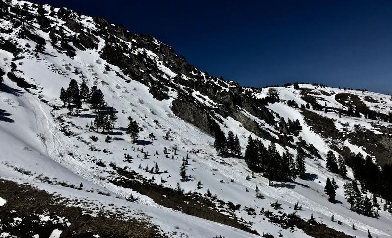
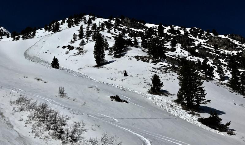
We observed a handful of recent natural wet loose avalanches in the Wellsville Mountain Wilderness yesterday, and we were easily able to trigger wet sluffs on sunny slopes by early afternoon.
Natural wet avalanches initiate from saturated snow falling off rocks or cliff bands and then they entrain more saturated surface snow as they run down the slope. These can get pretty big on sustained slopes.
Ad
Avalanche Problem #1
Wet Snow
Type
Location
Likelihood
Size
Description
  1. Loose wet avalanches are likely today on steep sunny slopes, especially near cliffs or rock bands where the snow surface is soft and saturated. People could easily trigger wet loose avalanches, and significant natural activity is possible. Dangerous wet slab avalanches have not yet been observed locally, but the exceptional heat may cause some to occur this weekend on very steep slopes with shallow snow cover and poor snow structure.
  2. Large, overhanging ridge-top cornices have grown recently, and people might be fooled into getting too close to the edge. Cornices tend to break back further than you might expect. The heat this weekend is likely to cause some to buckle or calve off and they could start wet avalanches on steep slopes below. Avoid travel on and below cornices this weekend.

Here is Mark's take from earlier this week on the current situation;
Additional Information
General Spring Travel Advise:
As daytime temperatures rise, softening the snow, the danger of wet avalanches will increase, so its a good idea to get in the habit of an early start and to plan on heading down before things get too sloppy.
-Watch for trees or other terrain traps below you if you venture onto steep slopes.
-If you start sinking deeply into wet snow, or if the snow you are traveling on becomes unsupportable due to the heat, it's time to leave.
Do you have the essential avalanche rescue gear (transceiver, probe, and shovel) and do you know how to use them? Watch this video to see how the three pieces of equipment work together. HERE

Please keep practicing with the Beacon Training Park at the Franklin Basin Trailhead. Test yourself and your riding partners. It is free, fun, and easy to use.
General Announcements
Visit this website with information about Responsible Winter Recreation by the Utah Office of Outdoor Recreation.
EMAIL ADVISORY. If you would like to get the daily advisory by email you subscribe HERE.
Remember your information can save lives. If you see anything we should know about, please help us out by submitting snow and avalanche observations....HERE. You can also call us at 801-524-5304, email by clicking HERE, or include #utavy in your Instagram, or @UAClogan on Twitter.
We will update this forecast by around 7:30 tomorrow morning.
This forecast is from the USDA Forest Service, which is solely responsible for its content. The forecast describes general avalanche conditions and local variations always occur.