Check out our Holiday Auction

Forecast for the Logan Area Mountains

Toby Weed
Issued by Toby Weed on
Tuesday morning, March 2, 2021
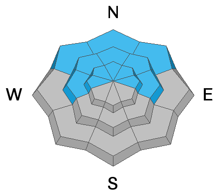
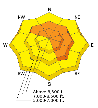
There is CONSIDERABLE avalanche danger on recently drifted slopes in the backcountry. People could trigger large avalanches failing 2 to 4 feet deep on a buried persistent weak layer near the ground if they venture into steep terrain, especially on upper and mid elevation slopes facing northwest through southeast. Large and dangerous avalanches still might be triggered remotely, from a distance, or below. Solar warming will cause elevated loose wet avalanche conditions on sunny slopes.
  • Expect unstable snow conditions, even if obvious signs of instability are absent.
  • Evaluate snow and terrain carefully, and make conservative decisions.
Low
Moderate
Considerable
High
Extreme
Learn how to read the forecast here
Weather and Snow
It's 24°F at the 8400' Tony Grove Snotel, and there is 80 inches of total snow and 84% of normal SWE. Winds from the south-southwest are blowing 30 mph at the CSI Logan Peak weather station. A sun-crust on sunny slopes will limit blowing snow today, but there was a good deal of drifting of the new snow from mostly westerly winds during the weekend storm. We're expecting sunny and warm conditions in the mountains again today, and continuing fair weather with gradually warming temperatures into the weekend. Temperatures at 8500' will top out at around 33°F today, and southwest winds will probably help ventilate those sunny slopes a bit. There is a chance for a little snow on Thursday, but we're expecting the gradual warmup to continue through the work week and into the weekend.
Recent Avalanches
A rider remotely triggered an avalanche on a drifted slope somewhere in the Elk Valley Area Sunday (2-28-2021), but details are a bit limited. Twitter report is HERE.
A few recent natural avalanches were reported with clearing after the weekend storm.
A large recent natural avalanche on a broad drifted mid elevation slope was observed west of Mantua from Hwy 89/91 yesterday.

Last Saturday, 2-20-2021, a 48-year-old Preston man was killed in an avalanche on the east side of Sherman Peak west of Georgetown Idaho. Our accident report is HERE.
Ad
Avalanche Problem #1
Persistent Weak Layer
Type
Location
Likelihood
Size
Description
Buried persistent weak layers consisting of sugary faceted snow are widespread across the Logan Zone, and the threat of large and deadly avalanches failing on weak snow near the ground remains quite real. People could trigger a large deep slab avalanche from a thinner part of the slab, and slopes with thin snow cover and therefore a thinner slab are more likely for people to trigger....
  • Avalanches failing on a buried persistent weak layer might be triggered remotely, from a distance, or worse from below!
  • Cracking and collapsing of the snow are a red flag, indicating unstable snow conditions.
Avalanche Problem #2
Wind Drifted Snow
Type
Location
Likelihood
Size
Description
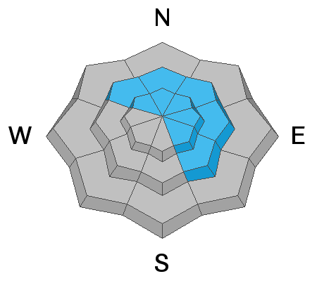
Avalanches of wind drifted snow are most likely on upper and mid elevation slopes facing northwest through southeast. Avalanches of wind drifted snow are likely where fresh drifts formed on steep slopes, especially on slopes with buried persistent weak layers. Steep rocky slopes at upper elevations, and mid elevation slopes with shallow overall snow cover (and a thinner slab) are the most suspect.
  • Watch for and avoid stiffer drifted snow near ridge tops and in and around terrain features like gullies, scoops, cliff bands, and sub ridges.
  • Wind slabs are often rounded and chalky looking, and they can sound and feel hollow and drum-like when you walk on them.
  • Stay well back from cornices as they can break much further back than you expect, and avalanches are possible on slopes below.
Avalanche Problem #3
Wet Snow
Type
Location
Likelihood
Size
Description
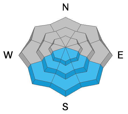
Strong March sun will rapidly warm up the surface snow and cause it to become moist, sticky, and prone to avalanching. Loose wet avalanches entraining large piles of saturated surface snow are possible in steep sunny terrain again today.
  • Even a small avalanche could be enough to cause problems, especially on steep slopes with trees or other terrain traps below.
  • Smaller wet avalanches overrunning a slope with buried persistent weak layers could step down into older snow near the ground and cause a much larger and more destructive avalanche.
Additional Information
Do you have the essential avalanche rescue gear (transceiver, probe, and shovel) and do you know how to use them? Watch this video to see how the three pieces of equipment work together. HERE
Please keep practicing with the Beacon Training Park at the Franklin Basin Trailhead. Test yourself and your riding partners. It is free, fun, and easy to use.
General Announcements
Visit this website with information about Responsible Winter Recreation by the Utah Office of Outdoor Recreation.
EMAIL ADVISORY. If you would like to get the daily advisory by email you subscribe HERE.
Remember your information can save lives. If you see anything we should know about, please help us out by submitting snow and avalanche observations....HERE. You can also call us at 801-524-5304, email by clicking HERE, or include #utavy in your tweet or Instagram.
I will update this forecast by around 7:30 tomorrow morning.
This forecast is from the USDA Forest Service, which is solely responsible for its content. The forecast describes general avalanche conditions and local variations always occur.