UDOT PLANNED AVALANCHE CLOSURES!!

Forecast for the Logan Area Mountains

Toby Weed
Issued by Toby Weed on
Tuesday morning, March 11, 2025
Heightened avalanche conditions exist in the backcountry and the avalanche danger is MODERATE. Warm temperatures and intense sun will elevate the hazard during the day; natural avalanches of wet snow and large cornice falls are possible. People could trigger wind slab avalanches in drifted upper elevation terrain and/or wet avalanches in sunny terrain on slopes steeper than 30 degrees.
  • Evaluate snow and terrain carefully, and continue to practice safe travel protocols.
  • Stay off and out from under overhanging cornices; they can break back much farther than expected and can trigger avalanches on slopes below.
Low
Moderate
Considerable
High
Extreme
Learn how to read the forecast here
Special Announcements
We are very sad to report a fatal avalanche accident occurred on Friday, March 7 in the Western Uinta Mountains near Kamas. Preliminary accident report is HERE
March kicks off our Spring Campaign! If everyone in Utah’s backcountry community donates the cost of something they regularly enjoy on an adventure—like a dawn patrol burrito, a backpack snack, or post-ride trailhead drinks—we could fund not just one but two forecasters for the entire season! Donate HERE.
Weather and Snow
Drifting by winds from the southwest created small wind slabs on the lee sides of major ridges and in and around upper elevation terrain features. The snow in select high shady terrain should still be in decent condition this morning, but we'll find surface crusts of differing thicknesses on most slopes. Once the sun climbs high enough, its sharp March angle will soften the crusts and rapidly turn the surface of the snow into cohesionless mush like a slushy from 7/11. As the snow becomes saturated, heightened avalanche conditions will develop, with natural wet avalanches and large cornice falls possible.
Low elevation terrain facing the south half of the compass is bare of snow or has only very shallow snow cover.

The Tony Grove Snotel at 8400 feet reports 32° F, with 92 inches of total snow. It's 32° F at the Card Canyon weather station with 69 inches of total snow. At 9700 feet at CSI's Logan Peak Wx station, winds are blowing 23 to 30 mph from the southwest, and it's 27° F. On Paris Peak at 9500 feet, it's 26° F, with winds blowing 19 to 24 mph from the southwest.

Expect another nice day in the mountains with clear skies, strong sunshine, and high temperatures at 8500 feet topping 40° F. Winds from the southwest will blow 9 to 15 mph. Tomorrow will be mostly sunny, with a high near 40° F, and winds from the southwest 13 to 18 mph, with gusts as high as 34 mph. A winter storm will impact the Logan Zone and elevate the avalanche danger beginning Wednesday night with increasing winds from the south-southwest. Snow will be heavy at times on Thursday, with 11 to 19 inches of accumulation in favored locations possible by Friday morning, and strong winds from the south-southwest will drift plenty of snow.

For more information, visit the UAC weather page here: Weather - Utah Avalanche Center
For Logan-specific weather, go here: Logan Mountain Weather - Utah Avalanche Center
Recent Avalanches
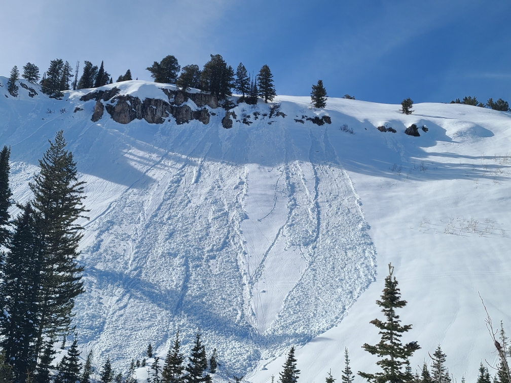
-Large and small natural wet avalanches were reported and observed in sunny terrain at all elevations across the zone in the past few days.
Read about all avalanches and observations HERE.
Ad
Avalanche Problem #1
Wet Snow
Type
Location
Likelihood
Size
Description
  • Human-triggered soft slab avalanches of moist snow up to two feet deep and perhaps 200 feet wide are still possible today on steep slopes in drifted mid and upper-elevation terrain.
  • Rapid warming today will elevate the danger of both wet loose and wet slab avalanches, especially in sunny terrain. Natural avalanches entraining significant piles of wet snow will become increasingly likely as the fresh snow becomes saturated due to surface melt.
  • If the snow you are in starts feeling sticky or moist, move to cooler aspects or higher elevations, or avoid travel in steep terrain altogether.
**People fishing in the Logan River should avoid being under steep snow-covered slopes, especially in places like the Dugway and the turns just below Temple Fork.
Avalanche Problem #2
Wind Drifted Snow
Type
Location
Likelihood
Size
Description
Drifting by winds blowing from the south-southwest created shallow but stiff wind slabs in upper elevation terrain. Watch for and avoid recent drifts on the lee side of major ridges, below cornices, and in and around terrain features like cliff bands, sub-ridges, and gully walls.
  • Cracking is a red flag indicating unstable snow.
  • Wind slabs sometimes let you get out on them before releasing suddenly.
Avalanche Problem #3
Cornice
Type
Location
Likelihood
Size
Description
  • Large natural cornice falls are likely during the heat of the day, and these could trigger slab avalanches of recent drifted storm snow on slopes beneath.
  • People should stay off of, out from under, and well away from large overhanging cornices, which are deceptive and often break much further back than expected.
Additional Information
Reports verify numerous natural wet avalanches occurred due to the warmth in the past few days across the zone on most aspects and elevations... Dean Harris sent in this picture with group of recent loose wet avalanches off a rock band in the Adams Corral area of Red Pine Ridge. Expect elevated wet avalanche conditions with warm temperatures again today.
General Announcements
-National Forest Winter Recreation Travel Maps show where it's open to ride: UWCNF Logan, Ogden LRD Tony Grove, Franklin Basin CTNF Montpelier
-For all questions on forecasts, education, Know Before You Go, events, online purchases, or fundraising, call 801-365-5522.
-Remember the information you provide could save lives, especially if you see or trigger an avalanche. To report an avalanche or submit an observation from the backcountry, go HERE.
-Receive forecast region-specific text message alerts to receive messages about changing avalanche conditions, watches, and warnings. Sign up and update your preferences HERE.
-We are excited to announce the launch of our new mobile application available on both Android and IOS. Get all the information you need to plan your backcountry adventure and keep the information at the tip of your fingers while you are out. Install the Android version HERE and the IOS version HERE.

This forecast is from the U.S.D.A. Forest Service, which is solely responsible for its content. This forecast describes general avalanche conditions, and local variations always occur.