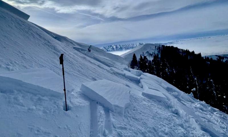
The snow is deep and you'll find really nice powder at all elevations in the backcountry, although the sun has moistened/crusted the snow surface on most southerly facing slopes. The new snow has settled significantly over the past few days and stable conditions exist in most areas. Strong winds from the south yesterday drifted snow in exposed terrain and built wind slabs, in some cases on weak surface snow.
The
Tony Grove Snotel at 8400' reports 97"of total snow (136% of normal SWE). After howling from the south yesterday, winds at the CSI Logan Peak weather station have subsided and veered from the west, currently 22 mph, and it's 17° F at 9700'.
Today will be sunny and temperatures at 8500' will top out around 31° F, with moderate winds from the west.
Tonight will be mostly cloudy with low temperatures around 18° F and increasing south wind.
Sunday It will snow, with 4 to 8 inches of accumulation and fairly strong winds from the south, (20 to 30 mph), with a high temperature near 30° F.
Moderate snowfall should continue Sunday night and into Monday, with an additional 4 to 9 inches possible.
A skier took one step out onto a recently drifted north facing slope on Friday and easily triggered a pretty good sized avalanche of wind drifted snow near the ridge in upper Logan Dry Canyon. We've counted a handful of human triggered avalanches and dozens of large natural avalanches in the Logan Zone due to last weekend's productive storm. For a list of local avalanches go
HERE
Find a list of all recent observations & avalanches from across Utah
HERE.
A skier took one step onto an obvious fresh wind slab and triggered a good sized avalanche near Logan Peak Friday.


