Check out our Holiday Auction

Forecast for the Logan Area Mountains

Toby Weed
Issued by Toby Weed on
Saturday morning, February 3, 2024
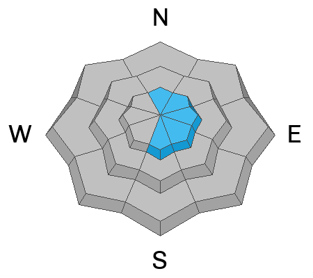
The avalanche danger is MODERATE in the Logan Zone. People could trigger shallow but long-running loose or soft slab avalanches of heavy new snow on slopes steeper than 30° at all elevations. Drifting by wind blowing from the west will create wind slabs in exposed upper-elevation terrain that will be easily triggered. Although becoming more unlikely, dangerous human-triggered hard slab avalanches failing on a persistent weak layer are possible in isolated rocky terrain with shallow snow cover.
Evaluate snow and terrain carefully. Avoid steep slopes where you might be carried by small avalanches into terrain traps below, like trees, cliff bands, or gullies, and steep rocky areas with shallow overall coverage.
Low
Moderate
Considerable
High
Extreme
Learn how to read the forecast here
Special Announcements
Sign up for forecast region-specific text message alerts. You will receive messages about changing avalanche conditions, watches, and warnings...HERE.
Weather and Snow
On slopes steeper than 30°, people could trigger shallow loose or soft slab avalanches of heavy new snow running further than expected on a slick melt-freeze crust from last week's warm spell. A few inches of new snow has really helped riding conditions. The heavy new snow smoothed in old tracks and caps a widespread crust at all elevations. The crust under the new snow is softer at lower elevations, and lower-angled slopes will offer much better conditions. A bit more new snow accumulated on the western slopes of the Bear River Range, with about 3 new inches overnight apparent on Cherry Peak's lit snow-stake cam and 4 or 5 inches of new snow at the new Card Canyon weather station.

The wind is blowing from the west-northwest this morning at 20 to 25 mph with gusts in the mid-40s at the 9700' CSI Logan Peak weather station, and it's 17° F. At 9500' on Paris Peak, it’s 16° F, and the wind is blowing 20 to 30 mph from the west.
The Tony Grove Snotel at 8400' reports 24° F and 2 inches of new snow. The station reports 73 inches of total snow, containing 115% of the average SWE (Snow Water Equivalent).

Today, expect snow in the mountains, with 2 to 4 inches of accumulation possible on upper-elevation slopes. High temperatures at 8500' are expected to be around 26° F, and it will be blustery, with 20 to 25 mph winds blowing from the west-northwest.
Tomorrow will be mostly sunny, with high temperatures around 29° F and a 10 mph west wind becoming south in the afternoon.
The next wave of storminess will arrive tomorrow night and continue into next week, with 8 to 16 inches of accumulation possible at upper elevations Monday and Monday night.
Recent Avalanches
We received reports of a few shallow avalanches of heavy new snow in the northern part of the zone. A snowboarder triggered a 2" x 40' soft slab that ran into trees and piled up a couple feet deep, and skiers in Bloomington Canyon triggered a few sluffs running further than expected on the widespread melt-freeze crust.
Check out local observations and avalanches HERE.
Ad
Avalanche Problem #1
Persistent Weak Layer
Type
Location
Likelihood
Size
Description
Although increasingly unlikely, hard slab avalanches failing on a buried persistent weak layer could be large and life-threatening. In January, heavy snow and drifting overloaded slopes plagued by a widespread persistent weak layer that formed in the December dry spell. Rapid warming over the weekend caused some slopes to be unstable and there were a few large avalanches. Cooling today will increase snow stability, but dangerous avalanches are still possible in steep rocky terrain with shallow snow and poor snowpack structure, a stiff slab on top of a layer of weak, sugary, or faceted snow.
  • Avalanches still might be triggered remotely, from a distance, or even from below!
  • Audible collapsing (or whumpfs), cracking, and recent avalanches are obvious signs of instability. However, these red flags may not be present when avalanches failing on a persistent weak layer occur.

Avalanche Problem #2
New Snow
Type
Location
Likelihood
Size
Description
Shallow loose and soft slab avalanches of heavy new snow are possible on steep slopes at all elevations across the zone. These could run faster and farther than expected on a slick crust and, in steep terrain, could push or carry people into terrain traps below, like trees, rocks, or gullies.
Avalanche Problem #3
Wind Drifted Snow
Type
Location
Likelihood
Size
Description
Drifting of the new snow by westerly winds today will create stiffer wind slabs on the lee side of major ridges and in and around terrain features like sub ridges, gully walls, mid-slope roll-overs, and under cliff bands. These will likely be easy for people to trigger, and small avalanches of stiffer, wind-drifted snow could run fast and far on the slick crust formed during last week's warm temperatures.
Additional Information
A snowboarder triggered and was surprised by a shallow slab avalanche in the Northern Bear River Range on Friday that packed a punch.

Skiers were a bit surprised by how far their shallow sluffs were running on a slick crust in Bloomington Canyon on Friday.
General Announcements
Here is Tuesday's short video about last weekend's large hard-slab avalanche on Wilderness Peak above Gibson Lakes in Franklin Basin, a few miles north of the UT/ID State Line.

-Read my recent blog about wind, drifting, and avalanches HERE
-Come practice companion rescue with your backcountry partners at the Franklin Basin TH beacon training park. video HERE.
-For all questions on forecasts, education, Know Before You Go, events, online purchases, or fundraising, call 801-365-5522.
-To report an avalanche or submit an observation from the backcountry, go HERE.
-I will update this forecast by 7:30 AM tomorrow.
This forecast is from the U.S.D.A. Forest Service, which is solely responsible for its content. This forecast describes general avalanche conditions, and local variations always occur.